Fancy Gyroscopes Are Key To Radio-Free Navigation

Back in the old days, finding out your location on Earth was a pretty involved endeavor. You had to look at stars, use fancy gimballed equipment to track your motion, or simply be able to track your steps really really well. Eventually, GPS would come along and make all that a bit redundant for a lot of use cases. That was all well and good, until it started getting jammed all over the place to frustrate militaries using super-accurate satellite-guided weapons.

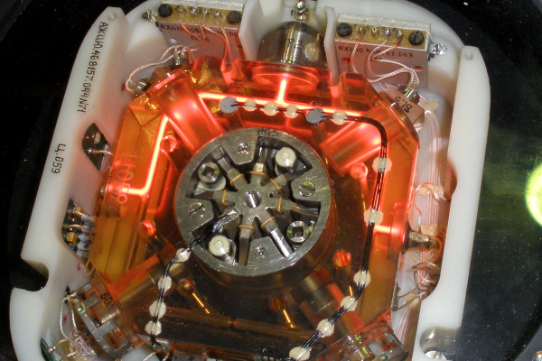
Today, there’s a great desire for more accurate navigational methods that don’t require outside communications that can easily be jammed. High-tech gyroscopes have long been a big part of that effort, allowing the construction of inertial navigation systems with greater accuracy than ever before.

Continue reading “Fancy Gyroscopes Are Key To Radio-Free Navigation”

This Is The Future Of Waste Management

Many of us have been asking for some time now “where are our robot servants?” We were promised this dream life of leisure and luxury, but we’re still waiting. Modern life is a very wasteful one, with items delivered to our doors with the click of a mouse, but the disposal of the packaging is still a manual affair. Wouldn’t it be great to be able to summon a robot to take the rubbish to the recycling, ideally have it fetch a beer at the same time? [James Bruton] shares this dream, and with his extensive robotics skillset, came up with the perfect solution; behold the Binbot 9000. (Video, embedded below the break)

Continue reading “This Is The Future Of Waste Management”

Turn By Turn Driving Directions From A Turntable

Many of us now carry a phone that can give us detailed directions from where we are to a destination of our choosing. This luxury became commonplace over the last decade plus, replacing the pen-and-paper solution of consulting a map to plan a trip and writing down steps along the way. During the trip we would have to manually keep track of which step we’re on, but wouldn’t it have been nice to have the car do that automatically? [Ars Technica] showed us that innovators were marketing solutions for automatic step by step driving directions in a car over a 100 years ago.

Systems like the Jones Live-Map obviously predated GPS satellites, so they used vehicle odometry. Given a starting point and a mechanical link to the drivetrain, these machines can calculate miles traversed and scroll to the corresponding place in the list of instructions. This is a concept that has been used in many different contexts since, including the “Next Bus in 7 Minutes” type of display at bus stops. Because a bus runs a fixed route, it is possible to determine location of a bus given its odometer reading transmitted over radio. This was useful before the days of cheap GPS receiver and cellular modems. But the odometry systems would go awry if a bus rerouted due to accidents or weather, and obviously the same would apply to those old school systems as well. Taking a detour or, as the article stated, even erratic driving would accumulate errors by the end of the trip.

The other shortcoming is that these systems predated text-to-speech, so reading the fine print on those wheels became a predecessor to today’s distracted driving problem. One of the patent diagrams explained the solution is to hand the device to a passenger to read. But if there’s a copilot available for reading, they can just as easily track the manual list of directions or use a map directly. The limited utility relative to complexity and cost is probably why those systems faded away. But the desire to solve the problem never faded, so every time new technology became available, someone would try again. Just as they did with a tape casette system in the 1970s and the computerized Etak in the 1980s.

[Photo by Seal Cove Auto Museum]

How Etak Paved The Way To Personal Navigation

Our recent “Retrotechtacular” feature on an early 1970s dead-reckoning car navigation system stirred a memory of another pre-GPS solution for the question that had vexed the motoring public on road trips into unfamiliar areas for decades: “Where the heck are we?” In an age when the tattered remains of long-outdated paper roadmaps were often the best navigational aid a driver had, the dream of an in-dash scrolling map seemed like something Q would build for James Bond to destroy.

And yet, in the mid-1980s, just such a device was designed and made available to the public. Dubbed Etak, the system was simultaneously far ahead of its time and doomed to failure by the constellation of global positioning satellites being assembled overhead as it was being rolled out. Given the constraints it was operating under, Etak worked very well, and even managed to introduce some of the features of modern GPS that we take for granted, such as searching for services and businesses. Here’s a little bit about how the system came to be and how it worked.

Continue reading “How Etak Paved The Way To Personal Navigation”

Retrotechtacular: Car Navigation Like It’s 1971

Anyone old enough to have driven before the GPS era probably wonders, as we do, how anyone ever found anything. Navigation back then meant outdated paper maps, long detours because of missed turns, and the far too frequent stops at dingy gas stations for the humiliation of asking for directions. It took forever sometimes, and though we got where we were going, it always seemed like there had to be a better way.

Indeed there was, but instead of waiting for the future and a constellation of satellites to guide the way, some clever folks in the early 1970s had a go at dead reckoning systems for car navigation. The video below shows one, called Cassette Navigation, in action. It consisted of a controller mounted under the dash and a modified cassette player. Special tapes, with spoken turn-by-turn instructions recorded for a specific route, were used. Each step was separated from the next by a tone, the length of which encoded the distance the car would cover before the next step needed to be played. The controller was hooked to the speedometer cable, and when the distance traveled corresponded to the tone length, the next instruction was played. There’s a long list of problems with this method, not least of which is no choice in road tunes while using it, but given the limitations at the time, it was pretty ingenious.

Dead reckoning is better than nothing, but it’s a far cry from GPS navigation. If you’re still baffled by how that cloud of satellites points you to the nearest Waffle House at 3:00 AM, check out our GPS primer for the details.

Continue reading “Retrotechtacular: Car Navigation Like It’s 1971”

Retrotechtacular: The Omega Navigational System

In 1971, the United States Navy launched the Omega navigational system for submarines and surface ships. The system used radio frequencies and phase difference calculations to determine global position. A network of eight (VLF) transmitter sites spread around the globe made up the system, which required the cooperation of six other nations.

Omega’s fix accuracy was somewhere between one and two nautical miles. Her eight transmitter stations were positioned around the Earth such that any single point on the planet could receive a usable signal from at least five stations. All of the transmitters were synchronized to a Cesium clock and emitted signals on a time-shared schedule.

LOP-thumb
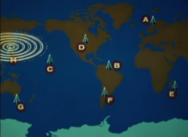
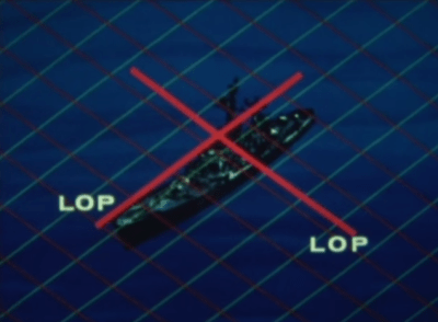
A ship’s receiving equipment performed navigation by comparing the phase difference between detected signals. This calculation was based around “lanes” that served to divvy up the distance between stations into equal divisions. A grid of these lanes formed by eight stations’ worth of overlapping signals provides intersecting lines of position (LOP) that give the sailor his fix.

In order for the lane numbers to have meaning, the sailor has to dial in his starting lane number in port based on the maps. He would then select the pair of stations nearest him, which were designated with the letters A to H. He would consult the skywave correction tables and make small adjustments for atmospheric conditions and other variances. Finally, he would set his lane number manually and set sail.

Continue reading “Retrotechtacular: The Omega Navigational System”