[Joop Brokking] wanted to know where his quadcopter was and had been. He thought about Google Earth, but assumed it would be difficult to get the GPS data and integrate it with Google’s imagery. But he discovered it was easier than he thought. He wound up spending around $10, although if his ‘copter didn’t already have GPS, it would have been more.
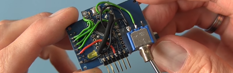
Hardware-wise, [Joop] made a pretty straightforward data logger using a small Arduino (a Pro Mini) and an SD Card (along with an SD breakout board). With this setup, NMEA data from the GPS comes in the Arduino’s serial port and winds up on the SD Card.
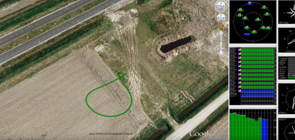 The interesting part, though, is the visualization of the captured data. [Joop] uses u-Center from uBlox. This Windows software can read the NEMA data from the logger and provides several ways to view it, including a Google Earth view of the flight track played back at different speeds and in 2D or 3D views (see picture to the right).
We’ve seen uBlox hardware used in automotive applications. We’ve even seen the hardware flying and collecting WiFi information. But if your flying vehicle already has GPS, this is a pretty easy way to get some very cool post flight data interpretation. You can see [Joop’s] creation in action in the video below.


If you add 2.4Ghz UART transmitter you can make it wireless and real time.
You can do it with Bluetooth too, though range may be limited.
If you remove arduino it would be useful.
At which point you would have an SD card, breakout, a couple of wires, heat shrink, and a single LED.
I would have thought that relatively useless in isolation. Something has to convert the serial data to SPI and run the FAT. What would you use?
Sorry; I forgot the spst switch.
How’s the view from your ivory tower?
I think you meant to say ‘useless’. I am not a fan of using an Arduino to blink an LED, but in this application – it is the right tool for the job.
“Vay nice, how much?”
It’s NMEA.
You know, too much cnc-stepper posts…
Ublox actually output a binary format if you select it in software. The newest of them both uses GPS, Glonass, Wass 60 satelites at the same time to get 1.5m precision at 10 HZ update, almost as good as military gps with it’s 3 extra scrambled digits.
I thought the military stopped degrading GPS precision.
Heh, go figure.
They did stop degrading unencrypted signal for civil use in ~2000. Military signal which is broadcast at different channel is still scrambled/encrypted.
Actually, the US military has used regular commercial GPS receivers for years. Three days before each Gulf War, SA (selective availability degrading) was turned off. Finally, someone’s brain functioned and SA was killed permanently. The high accuracy mode is carrier phase (transmitters are locked to atomic clocks) and you need to get a new password from the military every month to use it.
HAD often gets that one wrong, for some reason.
(isn’t NEMA an electrical outlet standard?)
me thought it was a stepper motor.
National Electrical Manufacturers Association.
In addition to lobbying activities, NEMA publishes more than 600 standards, application guides, white papers, and technical papers.
If you already have a GPS then the flight controller using it can probably already save a log!
Oops finger memory
Some do, but lots of SD cards won’t work at 5V – they’re supposed to work with a 3V3 supply and logic levels, as far as I am informed. Otherwise, a cool mash-up that I’m aching to tryout on the cats.
I love how there’s no mention in the video, or in this HaD article, of which gps enabled quadcopter platforms this works with, as I can tell you for free this won’t work with any DJI flight controller gps combo, plus many others, as they don’t output NMEA data on any serial port.
AFAIK DJIs kit uses the CAN bus for comms between FC and its GPS. Requires a CAN bus transceiver.
If you’re looking for a suitable GPS, they’re like 10-Bucks nowadays:
http://www.banggood.com/1-5Hz-VK2828U7G5LF-TTL-Ublox-GPS-Module-With-Antenna-p-965540.html?p=5G0704100426201212C9
Some uBlox GPS like the Neo7N/M8N have buildin flash that can automatically store GPS logs – no need for external hardware at all if all you need is a GPS tracker.