
A few weeks ago, China launched the final satellite in its BeiDou-3 satellite positioning system. Didn’t know that China had its own GPS? How about Europe’s Galileo, Russia’s GLONASS, or Japan’s QZSS? There’s a whole world of GPS-alikes out there. Let’s take a look.
The Global Positioning System (GPS) that we all know and love flew its first satellite in the distant past of 1978, just five years after the project began. Becoming fully operational in 1993, it was originally intended for use by the military. After decrees by government and the increase in civilian accuracy in 2000, GPS took the world by storm.
While open access to GPS spawned new industries and made navigation easier for everyone, governments worldwide were keenly aware that such a useful system was under the sole control of the United States. As more came to rely on it for day to day activities, it became clear to many that it would be advantageous to have a system under their own control.
These factors have led to the development of a spate of satellite navigation systems being developed by other nation states. Russia’s GLONASS, the European Union’s Galileo, and China’s BeiDou navigation system all offer comparable functionality to GPS. Meanwhile, Japan and India have both undertaken the construction of regional navigational systems, with QZSS and NAVIC, respectively. Each have their own unique qualities, and it bears learning about the relative systems and what they bring to satellite navigation.
GLONASS
The oldest system next to GPS, GLONASS was developed by the Soviet Union, kicking off in 1976. A little slower to come together, its full constellation of satellites was first completed in 1995. Russian economic issues led to the system falling out of maintenance, and global coverage was lost a few short years later.
It was only in the new millenium that proper funding was restored to the project. Since then, GLONASS has become a priority of Russian leadership, taking a full third of the Roscosmos budget. Global coverage was once again reached in 2013.
At its standard level of operation, GLONASS offers between 4.5 m and 7.4 m of accuracy – competitive with unaugmented GPS. Despite this, it was late to the party, and initially failed to find acceptance as GPS was already the favored choice. Regulations were put in place for a 25% import tariff for any GPS navigation device that didn’t also support GLONASS. This political move quickly changed things, with manufacturers making the effort to create devices that could take advantage of both satellite navigation systems. This had the additional benefit of improving acquire time, as receivers had a broader set of satellites from which to receive a fix.
Galileo
Kicking off in 1999, The European Union’s Galileo system was nearly scuppered before it got started, with the United States having severe reservations about the program. With the system offering high accuracy navigation to anyone and everyone, the US feared it could be used in attacks on its home territory. With the original frequency plan, it would be impractical for US forces to jam Galileo transmissions without also interfering with GPS used for their own weapons. However, the EU pushed on, coming to a compromise that the system would be built, albeit in a way that would leave the two systems using suitably seperate frequency allocations. The first craft was launched took place in 2011, with launches taking place thick and fast ever since.
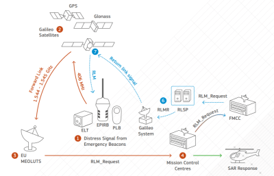
Plans also include implementing rudimentary two-way communication for the Galileo Search-and-Rescue service, allowing first responders to indicate to those seeking assistance that their call has been received and help is on the way.
BeiDou
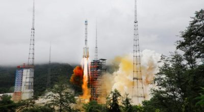
Spawned from discussions in the 1980s, China’s Beidou system kicked off with BeiDou-1, with the first launch taking place in 2000. A China-only regional system, it was superseded by BeiDou-2 which began launches in 2007 which began the march towards more global coverage. 2015 marked the start of BeiDou-3 deployment, with the final satellite of the constellation being launched on June 22, 2020.
With accuracy on the order of 10 meters for civilian use, it also delivers a military-only signal to the armies of China and Pakistan, reportedly down to 10 cm. Short messaging capability is also included in the platform, though whether this will be available to the general public is not clear at this time. Around 70% of Chinese smartphones already support the system. With China’s huge manufacturing muscle and massive population, expect BeiDou hardware to become commonplace incredibly quickly.
Regional Systems
Creating a global satellite navigation system is incredibly expensive. While the economic benefits can be huge, they’re not always readily capturable by those implementing the system, particularly now in a world where we have four. However, that doesn’t mean there aren’t gains to be had from throwing up a few satellites to augment things locally.
Japan’s QZSS system does just that, acting as a local support to standard GPS satellites. The goal was to create a regionally-specific system to help with GPS reception in urban canyons, where tall buildings make it difficult for receivers on the ground to see enough satellites to get a fix. Signals transmitted from the satellites are compatible with standard GPS receivers. First launched in 2010, the constellation currently consists of four satellites, with a further three planned.

India’s NAVIC system was partially borne out of a loss of GPS access in the midst of the Kargil War in 1999. The first launch took place in 2013, with the system declared operational five years later. With seven satellites currently in use, coverage extends up to 1,600 km from India’s borders. Using a dual-band system with transmissions at 1176 MHz and 2492 MHz to calculate atmospheric distortion, it aims to offer better accuracy than unaugmented GPS.
As in Russia, India is using goverment legislation to push adoption, and deals signed suggest smartphones could work with NAVIC signals as soon as this year.
What It Means For Users
For the average user on the street, the new systems coming online won’t be particularly noticable. It’s likely that smartphone chipsets will pack functionality with most, if not all, systems moving forward, allowing quicker fixes and more accurate positioning. For makers and hackers, there will be more options than ever for satellite navigation modules. For those seeking access to the most satellites possible, units like the ublox NEO-M8U will be attractive. Combined GPS/GLONASS receivers have already been around for years. Anyone out there using Galileo’s centimeter-level resolution?
For nation states, their leaders may sleep a little more soundly knowing that their military has accurate strike capabilities on lock, regardless of the whims of the USA. Conversely, they may fear their adversaries hitting their own soft targets with more precision than ever before. Realistically, positioning systems will just be yet another front on which electronic warfare rages on the battlefield. Incidents like Iran’s use of GPS spoofing are a great example of how these systems can be used and abused.
Regardless, it’s an exciting time for those interested in the cutting-edge of positioning technologies. We look forward to ever-more accurate data helping out with new technologies like drone deliveries, self driving cars, and just finding your way to that new happening coffee shop across town!


> This had the additional benefit of improving acquire time, as receivers had a broader set of satellites from which to receive a fix.
It also means that Russia can interfere with GPS devices by the back door. They may not spoof GPS signals without causing global uproar, but they can change their own GLONASS signals wherever they want, which causes devices that are using both systems to report inaccurate position. In most devices, there’s no way to choose which systems are used.
GLONASS is just an additional fix. If it fails, GPS will still work and device will get accurate position.
US can also deny GPS …
But in the case of spoofing, GLONASS doesn’t fail, it gets a lock that just doesn’t agree with GPS… so then which do you believe?
It depends on who you are, and where you are.
I wonder about programmed dead spots, I saw a Garmin, a Tom-Tom and google maps… and I think someone tried apple maps too (It was still independent) all go off by about 300 yards in different directions, and recently thinking about it, it seemed it was near a major-ish pipeline junction.
Developer choice. “Improving acquire time” to me means one system is trusted and always used when available. The other is only used if it locks faster, and it’s not used once the trusted system locks. Data could be impacted momentarily at the beginning.
Other developers, companies, or countries will have other ideas.
thats not really a problem for anything but commercial products which i see no reason Russia would want to mess with
Well, consider Ukraine. They had to mobilize against Russian-backed “rebels” with all the equipment they could muster, which mean setting up military logistics using commodity GPS navigators. Spoofing their signals would mean delays in logistics, while the rebels had the real deal military hardware provided by you know who.
Are you telling me that the people who live in Ukraine don’t know how to use Ukrainian roads and Ukrainian maps to navigate their own country?
Also the ability to spoof GPS is going to be a comparatively localized effect. you’re not going to be able to spoof the entire country and not piss off the countries around Ukraine. So at best if they did GPS spoof they would be able to make targeting their own troops difficult but otherwise it’s not really going to be an effective strategy to throw off the entire Ukrainian effort.
The russians repeatedly fucks around with gps navigation in the easternmost parts of north norway and north finland. The disturbance is sufficient to render satellite navigation unreliable for commercial fligts flying over the region. Russians use no logic in any endeavour. They cannot be trusted.
I’m talking about consumer devices and other equipment sold to the “lesser nations” that aren’t US, Russia, or China.
For example in Ukraine, when Russia started pushing little green men across the border and trucking guns to the “rebels”, the Ukranians had to quickly mobilize older Soviet artillery against them, which doesn’t have modern fire control – so they were using commodity smartphones as GPS receivers and calculators for an ersatz solution. Well, if you don’t know your position exactly, you can’t coordinate artillery effectively. Introducing some fuzz in the signal means your fire groupings are more dispersed and you can’t shoot at targets for fear of hitting something else. It means you have to fall back to older triangulation and map techniques, which take more time.
In that situation, where you’re trying to attack another country and disrupt their military and economy while pretending to be innocent, if they were disrupting GPS it would have been picked up by the west as direct evidence of their involvement.
You’re suggesting it’s nefarious of Russia to hypothetically try to disallow enemy nations from using GLONASS to attack Russia?
10/10 for mental gymnastics.
In systems where trust is an issue, it’s possible to blacklist systems and even individual satellites. These procedures exist and must be tested on, e.g. aviation FMS systems.
My Garmin 64ST allows me to choose which system or both.
” Regulations were put in place for a 25% import tariff for any GPS navigation device that didn’t also support GLONASS. This political move quickly changed things, with manufacturers making the effort to create devices that could take advantage of both satellite navigation systems. ”
How hard is it to create a multi-receiver?
Plus I wonder if all these differing frequencies will make atmospheric research more effective? Never mind the traditional uses better overall.
https://journals.ametsoc.org/bams/article/81/4/677/57186/SuomiNet-A-Real-Time-National-GPS-Network-for
“How hard is it to create a multi-receiver?”
It depends on the frequencies, data formats, baud rates of the systems you’d like to use.
I also wonder if the type of receiving antenna differs.
I think the biggest hurdle is power usage. You need a minimum bunch of satellite tracking units to get a good fix. 12 minimum for GPS, to get a reliable fix. If you want to have a good fix for both GPS and Glonass at the same time, you cannot share units, because every GPS system has it’s minimum of satellites to track. So you would have to double the amount of units in the chip for tracking two systems, and triple for three systems, etc. And that would double, triple, etc. the power usage as well.
Yes, you need a number of satellites for a good fix. But no, you don’t have to be running fixes on multiple constellations simultaneously. That is, depending on the number of satellites visible from your location, you can choose which system you are using. No extra power required. Keep in mind that the reason for having nav units that can use multiple formats, is that this reduces the likelihood that you will lose service because one nation decides to encrypt its signals. Not that this is really likely to help anyway, because in a situation where one nation decides to deny access to its network, the others would probably follow suit in short order. But there’s the other advantage, which is that if you are a manufacturer of portable navigation devices, you can deploy the same model worldwide, and market it as being GPS, Gemini, or GLONASS, depending on where you’re selling it.
Now it what you’re looking for is greater precision, then yes, you need to track more satellites, which yes, could mean higher power consumption. But you could give the user a “battery saver” option that limits the number of satellites being tracked. Also, it may be possible to correlate fixes between satellites on different systems, without having enough satellites on a given system for a good fix. All of these systems use the difference in time-of-flight from multiple transmitters to reach a solution. In principle, the signals you’re correlating don’t even have to be part of the same system, as long as you know the clock skew between the systems. This could be useful for getting a high-resolution fix, even if you only have three birds in sight for any given system, and this would take no more power than a fix from a single constellation. I don’t know if existing multi-format navigation units do this, but they could.
given that many mobile baseband chipsets use SDR in some shape or form just to be able to deal with the miriad of different frequency allocations, probably not all that much. + using SDR gives you the possibility of later modifications if the standards change.
It actually makes sense from an economical point to churn out a single but huge pile of chips that can do everything rather then having to deal with all the possible permutations of the 4 satellite systems and additional regional ones.
Due to different orbits, Glonass also has better performance than GPS over high latitude regions, something obviously important for Russia.
Yes, they need it for their new hypersonic missiles and nuclear cruise missiles that will be able to loiter for months. They ‘needed’ a system with update rate and altitude to handle ICBM speeds and apogee. And that they (the Czar Putin) control. I would not depend on it alone for air navigation.
You could have shortend your comment to just say “The Russian military built GLONASS for exactly the same reasons the US Military built GPS”.
They’re both military systems, which happen to have civilian uses as well.
High LATITUDE not ALTITUDE.
e.g. for northern regions such as Siberia.
Yes. I see that GPS has been used at over 116,000 miles from Earth and apparently will work from the Moon.
Erm, update rate is a function of the receiver, not the GNS constellation. You can easily run 10-20 updates per second on GPS, providing your receiver supports it. GPS software is supposed to stop working above a certain speed and/or altitude, to prevent military use, but there are products out there that you can flash with your own firmware, so any reasonably competent military should be able to bypass that, or failing that old fashioned inertial guidance is good enough to place a nuc near enough to a target as makes no difference.
As for nuclear cruise missiles loitering, they are damned dirty in terms of radioactive fallout from their drive, so any half sane government isn’t going to leave one up there on the off chance. All the declared nuclear powers maintain quick reaction capabilities to respond in case of sudden attack, so no real difference there either.
Yes a multi system would be nice, especially one that compared multi system data and threw out way out of spec data, in case of spoofing in one system. Only problem with BeiDou though is that it says every location is in China (or displays a “coming soon” message.)
System hacking with the purpose of hiding or misleading is a whole new type of ‘warfare’: https://www.wired.co.uk/article/russia-gps-spoofing
This is honestly the first time I’ve ever seen the word “scuppered”.
Yeah, I thought it was about a scullery cupboard.
B^)
Or maybe it is derived from “scuttled per d[irective]”
B^)
It’s not an uncommon word in English.
That’s right, and like many words it’s nautical in original form: https://en.wikipedia.org/wiki/Scupper
Well, finally this has reached the threshold of action, but at least the action required only clicking on your link. Now I know what a scupper is! Unfortunately, now I need to find out what a ‘gunwale’ is.
It’s pronounced “gun-el” (those Brits always shorten things). I think it’s that little rail/fence that goes around the outside edge of the the ship if there’s a walkway facing towards the water. Therefore a scupper is like a storm sewer grating that lets water on the deck flow back out and into the ocean. Like flushing a toilet ;^) ergo “scupper’d
@carpetbomberz
I’ll just leave this here:
https://pages.hep.wisc.edu/~jnb/charivarius.html
.. and if you’re really sadistic, you can point out that the word meow is in the middle of homeowner.
Dang, that 3rd last line finally got me though when I thought I knew enough to get through, I thought hough rhymed with though as an old form of hoe, but it can also be hock.
Hough like in lough, that’s the other homophone I couldn’t think of.
The ‘scupper’ as a drain to let water out is a noun. The ‘scuppered’ used here is the past tense of the verb ‘to scupper’, which is also nautical. and means to deliberatly sink your own boat, normally to stop the enemy getting it.
Most famously, the Germans scuppered their fleet at Scarpa Flow in 1918, and that is now one of the major sources of radiation free iron.
Minus the “r” in Scarpa. https://en.wikipedia.org/wiki/Scapa_Flow
Isn’t that ‘scuttle’ ??
Look up scupper in the context of wetsuits. Very different thing :p
Is there app to determine your position from photo of the starry night sky? (without using satelites)
I don’t know if there’s “an app for that”, but there certainly are systems that do that.
This is how satellites know their orientation. Using a “Star Tracker”
Terrible.
So much duplication of effort. So much extra space junk. All that extra pollution to launch it all.
Yah, I get why no nation would want to be dependent on another’s navigation system.
And that’s just another example of how humanity sucks. We are a species that is unworthy of spreading beyond our home planet before our eventual extinction on it’s surface.
I have to agree. This reminds me, in a way, of the cryptocurrency problem, where not only are prices of GPU chips being driven up, but large amounts of electrical power are being wasted, for nothing at all.
I don’t see a solution, though – I wondered if there might be a way to have an “open source” sort of navigation constellation, but there is no way to prevent a constellation operator from either limiting access or simply shutting it down.
Maybe a passive system, using corner reflectors? But no, this would then require enough power in each ground unit to handle the round-trip losses, which would also be impractical.
Maybe an expansion of ground-augmentation, to the point where the satellites become less and less significant? This would be a throwback, since such augmentation only works in areas covered by the ground stations.
It’s just a mess.
It’s ridiculous, what we need to develop is one universal navigation system that covers everyone’s use cases.
Obligatory XKCD: https://xkcd.com/927/
Set the hook, RW!
You’ve got a bite!
I KNEW there was an xkcd on this!
> It’s ridiculous, what we need to develop is one universal navigation system that covers everyone’s use cases.
Communist.
How are you going to get rich if you share control with everyone? Even worse, in the case there’s a dispute, you would have to *gasp* talk with your enemy and make a *gasp* compromise.
Yeah, in general you are right, humanity sadly won’t get anywhere long term. Its component parts are just too violent, greedy and self centred. Most are bright enough to know what is good for us long term, but history shows that just isn’t enough.
Ah well, in 100 years we’ll all be dead whatever. Meanwhile, there’s an RPi that needs a project…
Is this really true? I think there are deminishing returns. And having multiple independent systems which each give high accuracy information likely combine to produce accuracy and reliability far beyond any one system?
Different orbits, different frequencies, different encodings. All probably means that something which could completely put one system out of action (local terrain, atmosphere effects, jamming or noise) wont take them all out.
The different frequencies, if they’re in different bands, is the only serious challenge. But they’re not – the frequencies used by GPS, Galileo, GLONASS, QZSS, and BeiDou are close enough (all using frequencies close to 1200 and 1600 MHz) to use the same RF system for all. Multiple orbits, frequencies, and encodings can be (and ARE) handled easily by the chipset, for little if any extra cost. Chip makers don’t like having to have different chips for separate but functionally equivalent markets. I don’t think it was any accident that all of these systems use the same frequency bands – this allowed all of the newer systems to take advantage of chips developed for GPS. The rest is just differences in software and math.
A massive solar flare could probably “take them all out”
I don’t see how this helps, Grey. Speaking for myself, my I have concerns similar to what Circle expresses, based on observations of what is happening in the real world. It’s not my attitude that’s the problem; it’s the the attitudes of governments acting out ot fear, in ways that are highly wasteful, which I feel powerless to change. Can you point out an example of this ancient wisdom that leads to a solution here? And by “solution”, I mean to the actual problem, not a means of denying it.
Hmmm
Humanity sucks.
You are part of humanity.
If you find yourself so appalling surely you should make some gesture to ameliorate the situation.
I leave it to you to decide what excuse you will use not to do so.
Your comment reminds me so much of the people who complain about the overcrowding of the Earth. “Something must be done” they say. But they never volunteer themselves to cease taking up space and resources.
We live in a beautiful world which is getting better by the moment. The general level of wealth (measured in the widest sense) is increasing year on year, we have cleaner water, less disease, better communications and a longer lifespan than 50 years ago. Yes, we need to get better at getting on with people and finding ways of distributing resources more fairly but we can do so, given a positive approach rather than whining about the bad things and how unworthy we are.
Really Circle, if you don’t like it, get off your ass and do something about it. There’s plenty to do.
Okay, so you’re not going to address the issue, instead resorting to criticizing the person. So getting back to the actual issue, do you think it’s a good thing for there to be four independent satellite navigation systems in orbit, each requiring periodic replacement of individual satellites, just because every major power is afraid that the other major powers will deny them access?
“We live in a beautiful world which is getting better by the moment. ”
Climate change has a bone to pick with you.
We are still basically plains apes evolved to live in small disparate groups. The brain may be bigger, and anyone can write a code of very good rules to live by, but it takes very little to revert to our inner ape. You don’t need to have your eyes very wide open to see evidence of that all around. From the tweets of our leaders to the gossip down the pub.
If U.S open source their, GPS software and Hardware.
Nations will work on it like Linux.
Humanity will be the way you want it
Open source doesn’t help, because all of the satellite constellations are owned by governments, and can be disabled or otherwise made unavailable on the whims of those governments.
Cubesats are the closest we would come to a democratic navigation system.
Possibly, but there are some challenges there:
1) Need a high accuracy time reference. While this continues to evolve, the current crop of primary time standards are too big for cubesats. It may be possible to use lower-stability references, as long as they can be updated from the ground, but this in itself is quite a challenge, which is why atomic clocks are used in the existing navigational satellites.
2) High power transmitters. We can have GPS in portable devices, only because the transmitters in GPS satellites operate at sufficient power levels to not require large receiving antennas. And to go with high power transmitters, we also need large solar arrays.
3) Station keeping. Cubesats, at least for now, are in low orbits that decay rapidly. This requries all the receivers to have access to the current ephemerides of all of the satellites, and that new satellites be launched often enough to maintain the constellation. Cubesats are secondary payloads, and don’t have the luxury of being placed in exactly the desired orbit, and the addition of any kind of orbital correction thrusters would be expensive in volume and mass.
Brexit Britain has just invested in a low altitude sat company for GPS. And typically it is not fit for purpose.
I liked the part about US trying to block Galileo because it was too precise and someone could use it to attack the US. So who could do such an attack? Let\s see:
Terrorists are usually too stupid to make and use some kind of long-range missile or rocket to hit a small target. So all their attacks are usually low-tech and personal.
Most nations that hate USA usually don’t have necessary technology or financing or both to make their own long-range, transcontinental weapons. So they are out of picture too.
Some countries, like Pakistan or North Korea can’t reach USA with their weapons, they can only threaten some US allies, but these have their own defense system made in USA. Most of their missile launches fail anyway.
Nations that have sufficient technology and financing will either use their own navigation systems or use nuclear weapons, which don’t need to accurate to centimeter range. But they lack reason to do so.
So limiting satellite navigation systems for “safety” makes no sense at all. Especially if one takes into consideration the V2 rocket from WW2. It has 100% accuracy of 18km from the target, and 50% accuracy of 4,5km. That means that 50% of rockets would hit within 4,5km from the target. And it was done using electromechanical targeting and navigation system based around gyroscopes and altitude meters and some math made before launch.
A smart person with RPi, camera module and some clever coding could probably use combination of IMU measurements and some Google Maps photos with computer vision algorithms to achieve much greater precision without using satellite navigation. And probably centimeter range with it…
As for open-source navigation system, just make lots of base stations that use ISM band to send timecodes with their physical location, receiver can do the math. Synchronize clocks over internet…
Depending on the incompetence of your adversaries is never a good plan.
Very, very true.
Depending on limiting the accuracy of satellite navigation system, when there are plenty of alternatives is even worse idea. It makes people feel safe, when there is no reason to…
Also only Russia and China can threaten USA with missile attack, both have their own navigation systems, and for that reason US Army has plenty of defense and early warning systems. And they won’t attack USA directly. They will use economy and media manipulation, not warheads and missiles…
Iran.
North Korea.
Four completely independent systems are RELIABILITY and competition.
1) Who can guarantee that the world will not change in the future? After the First World War, everyone was convinced that a repetition of the world massacre was not possible …
Who knows if the US will be engulfed in civil war? Will there be a truly devastating epidemic in China? In Russia, the next collapse of the state into parts, and in Europe religious wars?
2) The more independent systems there are in the world, the better their owners will allow them to be. If you are the lord of one single system in the world, then limiting its accuracy is a logical step to create an advantage for your army. But as soon as the second system appears, all meaning in this completely disappears.
3) The resources spent on duplication are nothing compared to the benefits that it gives.
P.S. Those fans of Saint Gretta who are convinced of the sinfulness of humanity can reduce the carbon footprint by starting with themselves – natural rope can be found everywhere.
In Australia we use the Beer Scent Positioning Network, your location is determined by triangulating with regard to the nearest pubs. This has been partially disrupted by the covid-19 pandemic due to the large scale (and terribly wasteful) deployment of ethanol in hand wipes and sanitiser sprays.
Most articles in Hackaday are excellent. This one is so-so. These alternatives to GPS share the same flaws. They’re satellite-based and subject of various disruptions, deliberate and natural. The real alternative is a genuine alternative, a system like the projected eLoran, which uses powerful earth-based transmitters and is very costly to jam.
Ground-based navigation systems are limited by the wavelengths of the signals you’re locating on, for one thing. The big advantages of satellite-based systems operating in the L band:
1) Short wavelengths (around .25m for L-band) allows for good precision.
2) Antennas can be small and still directional, for portability.
3) By using directional antennas, you can look directly at each satellite, avoiding multipath distortion that causes position errors.
What would it take to have a navigation system based only on passively measurable variables? Suppose you have:
-inertial measurements (gyroscope, accelerometer)
-360 degree camera
-magnetic compass
-real time clock
-air pressure sensor
-a sufficiently powerful computer
The task is basically to keep accurate dead reckoning relative to a known object, and fix the location of that object based on celestial observations. An AI program could in principle figure out where it is in the world when you take it outside to see the sun.
What else would you need?
You are describing what we used for navigation before GPS. In those days, it was low resolution, it drifted over time, and was unreliable. This was completely unacceptable for aviation, for example, which was why VOR, ILS,and DME were invented. All of these depended on ground stations, but they were far more accurate than any of the methods based on passive sensors, but even so, navigation was made much more accurate and precise by GPS.
Hi, Lewin!
In the caption for the GALILEO Return Link diagram, would you mind linking to the source ESA article? https://gssc.esa.int/navipedia/index.php/Galileo_Search_and_Rescue_Service
Thanks, I’ve added a citation.