When it comes to hunting down military radar installations and associated hardware, we typically think of equipment that is firmly in the price bracket of nation states and their military forces. Whether it’s early warning radar, those used for air defence, or for naval purposes, you’d think it was relatively difficult to intercept or track these emissions.
However, a new tool built by geocomputation lecturer Ollie Ballinger shows this isn’t the case. In fact, openly-available data captured via satellite can be used to find all manner of military radar emitters. Let’s explore how!
Open Data Reveals Surprising Things
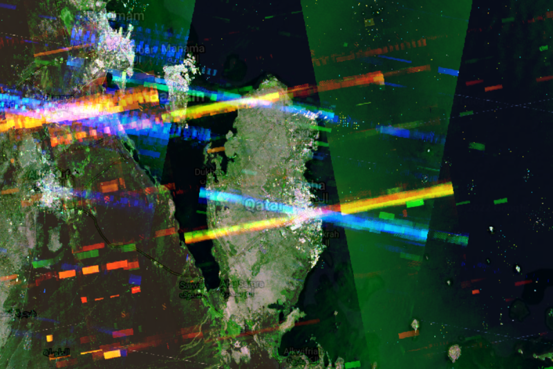
The discovery that openly-available satellite data could reveal the locations of military radars came from the work of Harel Dan, a geospatial engineer from Israel. Dan was looking at data captured by the synthetic aperture radar of the European Space Agency’s Sentinel satellites. After accidentally maximising the display of noise and interference on the synthetic images, he noticed strange bands appearing in various spots in the Middle East, and investigation into the cause began.
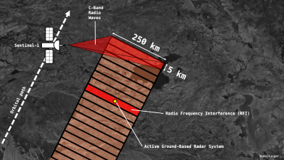
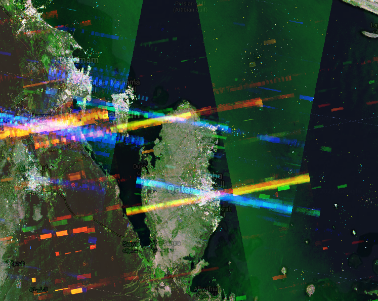
The Sentinel-1A and Sentinel-1B satellites, operated by the European Space Agency (ESA), carry synthetic aperture radar (SAR) instruments operating in the C-band, the spectrum taking in frequencies from 4.0 to 8.0 GHz. The SAR essentially uses the motion of the spacecraft to create a large “synthetic” antenna aperture for capturing radar images of the ground. The technique allows the SAR to image the ground as if it had a much larger antenna than it actually does, thanks to the spacecraft’s motion. It gives the SAR a far higher spatial resolution than is possible using a traditional scanning beam radar.
The SAR imaging systems on board the Sentinel satellites operate within the same frequency range as many military radars. As the satellites passed overhead, sending out radar signals to the ground and picking up the returns, they were also picking up emissions from military radar systems, which were showing up as bright blue and red bands on the SAR radar pictures.
As it turns out, Dan was seeing interference caused by MIM-104 Patriot PAC-2 aerial defence systems installed in various Middle Eastern states. Given that the ESA makes all data from the Sentinel satellites publicly available, this meant that anyone with a mind to delve into the data could see this interference as well.
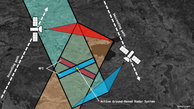
The Sentinel satellites typically operate in a mode where they image strips of land 250 km long and 5 km wide with their radar apparatus. When a military radar system is in operation in one such swathe of land, it creates a bright streak across the entire 250 km x 5 km strip. When images from Sentinel-1A and Sentinel-1B are overlaid, it’s possible to see a point where two stripes affected by interference cross each other. This can narrow down the area in which the radar system could be located – in the overlap between the two interference stripes.
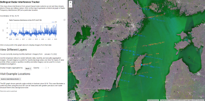
Armed with the knowledge of this phenomena, Ollie Ballinger set about building a tool to more easily allow researchers to look for radars using publicly-available data from the Sentinel-1 satellites – the Radar Interference Tracker (RIT). It can reveal interference picked up from a wide range of military radars, from US-built Patriot systems, to the Japanese FCS-3, Chinese Type-381, and even the Russian S-400 surface-to-air missile system. If these systems have their radar switched on when a Sentinel-1 satellite passes overhead, they should be visible on the RIT.
The tool lets users look at data from given points in time, helping researchers find out when and where military radar systems were switched on. Graphs of interference picked up by the satellites over time help find relevant time periods quickly.
It bears noting that the RIT is not a conclusive intelligence tool all on its own. Often, interference found on these images must be corroborated with other optical satellite imaging data or other intelligence reports to confirm movements of military hardware. A further issue is that the satellites take several days to revisit a given area; if a radar is turned on and back off in between satellite passes, it won’t show up in the data. However, the RIT can still prove useful for quickly identifying areas of interest with regards to military radar hardware.
It’s great to see the ESA sharing satellite data for anyone to use, and it’s also wonderful to see open-source tools improving what can be done with said data. Those interested in the RIT can even dive into the code themselves on Github. It goes to show what can be done by the broader community when information is made available to all!
(Editor’s Note: This article was conceived and written before Russia’s invasion of Ukraine.)


Timely and amazing! Though possibly a security risk as enemies could use it to “fly under the radar”, or around it.
I suspect most already know about it.
Large militaries would have this data but smaller or less well equipped ones could find this useful. I’m sure North Korea is already using this to check out radar locations in South Korea and Japan.
Not much point for them. Most of the North Korean hardware wouldn’t benefit from this knowledge (it’s extremely basic long-range artillery, often without even having a radio for command and control purposes). More than enough to threaten Seoul’s population via indiscriminate bombardment, but it’s not really concerned with (or able to use) information about radar systems.
Their vaunted nuclear missiles aren’t sufficiently precise to use the information either… and to aim at anything that would be useful as a target, it’s unavoidable to fly through the radar umbrellas of many air defense systems. Ballistic missiles are at high altitudes, so radar detection distance isn’t limited by horizon range.
Shoot a ballistic missile from North Korea to Japan and it inevitably crosses through hundreds of radars capable of detecting it. This matters because the Patriot and similar systems don’t have to use their own radars to engage a target, if some other radar can give them a position-vector-velocity fix.
Also, one of the points of widely deploying US Arleigh Burke class ships is that their Aegis air-defense systems have been upgraded to both track and intercept high-altitude ballistic missiles. Shooting down a satellite may have been a gimmick, but it’s a more challenging intercept problem than an ICBM. Even when a target doesn’t cross one ship’s interception envelope (where its own missiles can reach the target), the resulting fix of the missile’s position, vector, and velocity can allow air defense systems further downrage to do a blind engagement and kill it.
Knowing where the radars is is actually interesting for a different reason entirely. Knowing where someone has placed radars tells you that they have something there they consider worth spending serious money to defend. In other words, it gives you a list of targets they’d hate to lose. An opponent may then use this information to deliver a totally different kind of weapon to that location, avoiding challenging the air defense system entirely.
It’s not a new consideration, either. Making a campfire to protect your camp does indeed protect against one class of threats, but it can signal to others that there’s a camp at this location that they would not otherwise have known about.
I heard a story that in WWii, German military sites, such as radars, were hard to spot from the air.
After a few attacks by resistance units, the Germans started to fence the radar sites. It’s difficult to mow right up to chain link fencing, or under barbed wire.
A well-defined circle of vegetation is a good aiming point…
I’m not sure how an enemy would use such sparse measurements. Big players have dedicated electronics recon systems like the RC-135w Rivet Joint and rc-135u Combat Sent to gather huge amounts of information on radars and communications systems deployed by potentially hostile state actors. NATO and the US are currently running Rivet Joint (US & UK) and NATO AWACS very close to the Eastern borders of NATO member countries. They also have Global Hawk surveying foreign military assets everywhere from the black sea to Kaliningrad.
Signals gathering aircraft do have limitations on the distance they can “see” past a border. Also if an adversary really wanted to keep secrets they would have spotters and keep radar units off or on a known frequency when a bird was operating. I’m sure that the big three nations have satellite’s that try to pick up radio communication and radar signatures, however the atmospheric conditions make that a great challenge as well. There might very well be new data to be had from existing satellites that might prove helpful in the age old game of can and mouse
These radars scream electronically into the sky and combat aircraft have a receiver to easily detect them. All this is doing is making it public and accessible while sitting at home. I’ve even accidentally found a less known L band radar with a cheap TV tuner stick.
Oof! I looked at it and it’s part of whole mapping ecosystem based around Google. We all know Google drops products like hot cakes, so I would not recommend using this platform for anything but a bit of fun.
Sentinel 1a and 1b are not google based, and neither are the EO viewers they have published that allow you to do band calculations. Also, the imagery is available for download into any GIS package that can handle it.
Theres nothing here that is google centric except the use of their EE platform. That part is replaceable.
@Gravis said: “Oof! I looked at it and it’s part of whole mapping ecosystem based around Google.”
Using public sources to build intelligence is a thing, it’s called Open-Source Intelligence or OSINT.[1] OSINT done right is robust because it depends on redundant-overlapping information sources.
1. Open-Source Intelligence or OSINT
https://en.wikipedia.org/wiki/Open-source_intelligence
Meh, all the real systems are passive and use distributed receivers, everything else is out of date and vulnerable to anti radar missiles.
Depends on what you want to do. The iron dome in Israel tries also to defend against super dump, trajectory-launched mortars. The mortar doesnt notice a radarbeam scanning over it and locking on. Gravity doesnt care and inertia does its thing. One could active-Radar the shit out of this mortar and no harm is done.
I’m looking for other stuff with WebSDR’s around Europe. If you know of any not usually listed please DM me.
Ideally Poland, and thee like.
GIving civilians the first tools for SEAD strikes… sounds interesting!