Mining projects are approved or disapproved based on all kinds of reasons. There are economic concerns, logistical matters, and environmental considerations to be made. Mining operations can be highly polluting, or they can have outsized effects on a given area by sheer virtue of the material they remove or the byproducts they leave behind.
For a proposed lithium mining operation north of Las Vegas, though, an altogether stranger objection has arisen. NASA has been using the plot of land as a calibration tool, and it doesn’t want any upstart miners messing with its work.
I Like It, I’m Not Gonna Crack
Mining for lithium has long been a point of contention between environmentalists, local tribal leaders, and mining companies in Nevada. As companies and governments desperately scramble to secure vital raw materials for batteries, yet another challenge has arisen in the state. NASA has called dibs on a stretch of Nevada desert that is also one of the biggest lithium hotspots in the world, causing a face-off of legislative proportions.
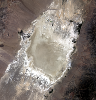
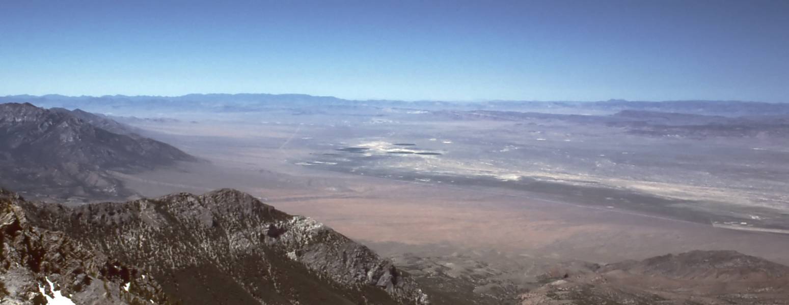
This fight is over a 36 square-mile patch of eastern Nevada terrain in Railroad Valley. The dry lakebed is notable for its tabletop flatness and undisturbed surface. The land sits atop a massive lithium deposit which could support a great deal of battery manufacturing to help in the fight against climate change. The valley contains an evaporated deposit of minerals in both liquid and solid form. Its size makes it attractive to both miners and NASA alike. It’s believed to be one of the ten largest lithium deposits in the world, with a vein of salt deposits 600 meters thick.
NASA, however, argues that this land’s unique characteristics make it an indispensable tool for calibrating the precise measurements of hundreds of satellites that circle our planet. For nearly three decades, this untouched, lengthy stretch of Nevada’s Railroad Valley has been a key site for keeping the data of hundreds of satellites spot-on, by acting as a stable calibration source. These satellites are integral to everything from weather forecasting, agricultural outlooks, and natural disaster responses to national security. The irony of it all? The same instruments being used to monitor climate change are squaring off with the mining of an element critical for cleaner, greener energy.
For scientists, for whom absolute precision is paramount, the uninterrupted topography of this Nevada desert has served as a vital constant, helping scientists assure “absolute radiometric calibration” of sensors aboard satellites.
For this reason, 23,000 acres in the area was withdrawn from any potential public and private use at NASA’s request, coming into effect from April 27 this year. The area has been in use by the agency since 1993 as a calibration source. Earth science instruments on NASA’s Aqua, Terra, and Landsat satellites rely on taking measurements of the area, along with a variety of other missions. The large flat area is free of vegetation and of a consistent color, making it an ideal calibration source for satellite instruments. It’s particularly crucial for space-based radar calibrations that feed into satellite geodesy efforts.
Disturbances to this land, NASA argues, could pose a severe threat to the quality of data that a plethora of economic sectors rely on. “Activities that stand to disrupt the surface integrity of Railroad Valley would risk making the site unusable,” said Jeremy Eggers, a spokesman for NASA’s Goddard Space Flight Center.
However, these reasons don’t sit well with everyone. The U.S. Bureau of Land Management’s decision to withdraw the tract from potential mining use has caused an uproar among those who believe that lithium extraction should take precedence. Notable among these critics is Congressman Mark Amodei, who has introduced legislation aimed at revoking the withdrawal decision. The representative has called out the decision for frustrating efforts to tackle climate change, an avowed goal of the current federal government.
The primary holder of the mining claims in this disputed tract, 3 Proton Lithium Inc., has also voiced concerns. The company claims that its extraction process won’t disturb the surface of the land significantly. The method involves pumping brine-based lithium from underground resources. However, NASA remains skeptical of these claims, and first submitted its withdrawal request in 2019, before the company had submitted any formal plans for the project.
The Bureau of Land Management finds itself in the middle of a modern-day paradox. On one hand, there’s a pressing need to reduce greenhouse gases and transition to cleaner sources of energy, and lithium plays a critical role in this regard. On the other hand, satellites need the area to calibrate their precise measurements to continue accurately monitoring our planet and its warming atmosphere.
The battle between lithium mining and satellite calibration isn’t just a simple toss-up between two worthy goals. Rather, it speaks to the broader challenge of managing our planet’s resources in an era of increasing technological advancement and environmental concerns. It’s a difficult balancing act.
Realistically, though, there are other places for miners to find lithium. In contrast, NASA and the Bureau of Land Management have noted that there isn’t a single other region of the United States suitable for making their calibrations. Even if there were, it would make sense to stick with what already works. This would ensure the most reliable scientific data is available going forward.
For now, the decision to protect the Railroad Valley in Nevada stands. This emphasizes the importance of reliable, scientific data that not only underpins multiple sectors of our economy, but gives us the vital knowledge we need about the Earth’s changing climate.
In the meantime, the world watches on as business and political interests wrangle with the national space agency in a fight between science and profits. Who knew a desert in Nevada could become such a hotbed of debate?


The mining company should buy a 36 square-mile patch of land make it mirror smooth and cover it in a one inch layer of whatever would provide the best calibration target for NASA satellites – Job done.
They have absolutely no interest in doing anything more than the bare minimum that will convince some politician to boot NASA off their “god-given mining profits”. If they get their way, and it (inevitably) turns out that their mining operations critically ruin NASA’s operation, they’ll just shrug their shoulders and say “oh but we thought it would be ok” and laugh all the way back to their yachts.
^^^ this. Even though there are supposed to be funds available to restore the site after the mine is gone, there is never any money in it or it is emptied during the bankruptcy which they all seem to do.
OK, it seems insane to me that NASA Goddard is claiming they cannot calibrate their sensors in any other way than reserving massive portions of Nevada as a calibration target. This is absolutely nuts.
36 square miles is not massive; it’s only .03% of Nevada.
Or dig the lithium out with sub surface mining / mines.
At what depth(s) is the lithium?
afaiu they don’t dig, they inject water and pump out brine
Problem is that even (deep) sub surface mining will affect the surface and it’s very likely the super flat salt bed wouldn’t be super flat anymore if they start tunneling under it.
And as [fonz] notes, they’d probably be extracting the salts using an injection process, which would definitely screw up the surface too. Not to mention the discoloration from te inevitable runoff
That’s what they’re trying to do, but NASA Goddard ignored that. NASA Goddard is being totally unreasonable here.
No they’re not… People need to piss off and let space advancement happen. It’s ok, Lithium will be obsolete for batteries soon and they can all fight about some other crap
Or NASA should buy their own plot of land and cover it in a mirror smooth coating of pumpkin spice soy latte.
The government already owns that land.
Difficult to calibrate colors when it’s all pumpkin spice soy latte colored.
The ‘pumpkin spice soy latte’ comment really lifts the veil, huh? Clicking through to that politician’s site didn’t surprise on political leanings either.
Any halfway competent engineer would understand the value of preserving the calibration target. Yes, it’s a pretty mid approach by today’s standards but when you’ve been launching satellites for decades, *and the populace has come to depend on them*, there’s a serious cost to distributing that stuff.
All that to say:
We live in a society and should care for other human beings. That’s really the most offensive thing to *that* political leaning. Go be a decent human.
Why? The mining company says they will not disturb the surface significantly.
I’d wager that the mining companies defenition of ‘significantly’ differs somewhat to NASA’s requirements…
And mining companies have always been known to be environmentally conscious and keep their word/obligation, right? Lemme just check a bit of history here and… oh… oh dear. Oh no…
hahahahahahaha!!!!!!
Why is it the mining companies responsibility and not NASA? It’s unclear from the article who owns the land but if the mining company does it would be absurd if NASA knocked on your door and told you that if you dig a hole in your back yard satellites will come crashing down so why is it acceptable here. They could have bought this land when they decided to use it or they could make a solution. Relying on retroactive eminent domain light is absurd.
It’s public land, so owned by the United States of America and under control/jurisdiction of the Bureau of Land Management. The question is what is the best use of this bit of public land. The mining companies will of course say to extract all that lovely wealth from it (while paying the government a relative pittance), NASA has it’s use. And right now it seems NASA is winning the argument. It won’t last of course, they’ll just pay off some more politicians and then the wealthy get their wish
It won’t be a pittance – it will be just right amount to garner the approval from the appropriate government representatives.
After that what ever the value agreed in will be appropriately approved and accepted.
The money people have when they come in to politics should cause no issue. It’s the money they make WHILE IN politics one should be concerned about.
If enough climate activists glued themselves to the lake bed it would be worthless as a calibration site. Problem solved! Spread the word.
I bet they’ll find some redneck to plow that plot, like the idiot that plowed Nasca drawings.
OK with me. I’m not very pleased by DC claiming ownership of 90% of the West. I will bet good money that NASA can do it any number of ways. What do they do when it is cloudy? What is wrong with Eniwetok?
It’s a desert in Nevada. How often do you think there are clouds?
This year with la NINA degrading, pretty much every day so far here in Reno
radar doesn’t care about clouds.
The latest of those idiots were ‘Greenpeace’. They ran like Frenchmen. Still have warrants.
Of course it’s not news that Greenies are idiots.
i had to re-read your comment several times. i didn’t believe anyone here could say something so asinine. it appears I thought too highly of this site’s users. ho hum.
was….was that a Nirvana reference?
my god, im literarily aroused!
Lithium batteries are, at best, a bandage-grade solution. A lot of ‘green’ tech focusing on “lower emissions” really just moves the issue to a less conspicuous place — for example, I have to wonder how many Tesla owners spend their top-up time contemplating where all that electricity comes from.
The answer is power plants that burn natural gas, for the most part… most of which are former coal plants that got converted because it was cheaper to refit them for gas and run them that way, starting a decade or two ago. Sure, bulk generation at power plants is somewhat more efficient, but it’s still a major emissions source.
Really the most noxious part of this, to me, is that none of it addresses what is actually the biggest problem in climate change and the gases emitted, and that’s actually food production. A farmer wrote an EXCELLENT open letter to Former President Obama in January 2009, just before his inauguration, about the matter. One of the few things I can actually say disappointed me about Obama’s leadership is that, to my knowledge, that letter was never even acknowledged. There’s a full copy on NPR’s website, IIRC. Worth a read.
Really the best thing for everyone would be if we didn’t have a global economy predicated on the abundant availability of cheap energy, but I don’t think that’s a thing that’s reasonably going to change in my lifetime and I’m almost 40. But maybe we could do something about the other big stuff… yes, transportation is an issue. But it’s not the only one, or even the biggest one, as I’ve said.
Public transit that works, and better transportation infrastructure in the first place would be good. But the way food production works needs a lot of rethinking as well… as does a lot of stuff, really.
Perhaps the best place to start would be, of all things, education. After all, arguably the biggest issue of them all here isn’t to do with emissions itself, it’s that too many people have never learned the difference between “green” and “sustainable”.
A BEV fueled with oil-fired power plants saves about 50% in CO2 emissions compared to a petrol car. More so with natural gas, and way more if renewable sources are used.
Battery Electric Vehicles are the best option we have right now, although hydrogen as an energy carrier seems to be ready to become more mainstream.
Waiting for that and keeping running on fossils (100-∞% more CO2 compared to battery or hydrogen) is not an option now.
The Governor of California stopped drilling and pumping in the state and there are no operating refineries except one small specialized unit. All the fuel is coming from Saudi Arabia. Jet fuel, truck and farm fuel, car fuel, electric generation fuel. The oil tankers produce as much CO2 in their 24,000 mile round trip as the vehicles that will burn the delivered fuel.
This is how you get EV’s that are making as much carbon as an equivalent ICE and ICE’s producing twice as much as they did 10 years ago. Basically he has double the carbon footprint of the entire ensemble of vehicles. Or so it is said.
Yes, hard to believe. I had to check multiple sources and calculations and it is still shocking.
“multiple sources”
Fox News *and* Newsmax! I have known few people as proudly misinformed as yourself.
msm is bad at math. ive caught both left and right wing “news” “sources” grossly misrepresenting data. they will take the same scientific paper and both will find a way to spin it in a direction that supports their established narratives. anyone using that as a source is a fool. then again so is anyone who embraces one narrative or the other and will accuse anyone who disagrees with them as being of the other side as a cheap way to prove them wrong and gain points with their peers. if you dont like the data, maybe your opinion is the problem. a good scientist has that attitude.
Brilliant research Bob. You must have checked the Workers World Daily as read on NPR? https://sscs.mit.edu/wp-content/uploads/2020/10/Well-to-tank-carbon-emissions-from-crude-oil-maritime-transportation.pdf
I guess the “multiples sites” were Shell, BP & Exxon.
Lets use one of your sources. https://www.dailymail.co.uk/sciencetech/article-1229857/How-16-ships-create-pollution-cars-world.html
I can tell you from personal experience. I drive by wells right here in Southern California that continue their endless teetering cycle. Nobody has stopped them pumping.
Sometimes you wish these people were paid shills, and not just idiots who fervently believe this stuff for whatever reason.
Yes, there are old grasshoppers running. They get a little oil. What do they do with it?
Correction. The tankers emit as much sulfur……
Would you be willing to reasonably consider an alternative if it were to be proposed?
I’m surprised BLM agreed. Normally if a national landmark can be stripped for cash they’re all over it. They’re almost done selling the bonneville salt flats off to intrepid potash. Down from several feet to a few inches of salt over the last 50 years.
It is always easier to destroy something than to build :(
As a calibration site it may serve for a few centuries. As a source of battery stuff it’ll be gone in a few decades (if Lithium batteries haven’t been replaced with something better before that).
there are other dry lake beds in the us, other salt flats. i don’t think its so much a matter of those sites being unsuitable but rather that its going to take a room full of math nerds to crunch the numbers to adjust their calibration algorithms for the new site. ultimately its the additional costs of this, and flashing all the firmware on all the satellites that makes switching sites an undesirable thing. however if the prospective miners foot the bill and make nasa whole, then i don’t see a problem.
NASA (The Federal Government) will get all the taxes and benefits from the mining, or rent or lease or whatever they will do.
I’d wager part of the kerfuffle is that the calibration site usage and resultant data does back to the beginnings of the Space Age. Shifting to a new site pretty much invalidates 50+ years of collected data.
I’d liken it to that janitor that unplugged that university freezer a couple of weeks ago, wiping out 20 years of collected samples. Not something that can be easily replaced, even with a new calibration site.
“Shifting to a new site pretty much invalidates 50+ years of collected data.” What could cause that?
well, if you’re wanting to compare current sensor capability with previous models (or even with the same sensor to see if it has degraded or improved over time), it really helps to be taking readings of the same target so that the data is an apples-to-apples comparison.
still think its a case that the site is just well characterized, more so than any alternative. but you can use anything as a calibration reference if you can thoroughly characterize it. any salt flat can be used for consistent altitude data. not sure any data would be ruined, you might need to use a conversion table to use a different reference. you might lose some accuracy in the conversion but i cant imagine it being an unresolvable problem.
you could make the case that climate change may alter the site anyway and that at least one backup site should be characterized and maintained in case something happens to their only point of reference. i find it disturbing that an organization like nasa would put all their eggs in one basket.
IIRC the White Sands of southeast New Mexico are also used for satellite imagery calibration.
Certainly true. It is too much like momentum, and unwilling to release control. There must be several good jobs related to that site. But the dry lakes fairly routinely get wet and expand and shrink in altitude and recrystallize on the surface. The albedo must change quite a bit.
I suspect it is not used as a reference over time, but a target for multiple devices to use at the same time and match calibrations. There are a lot of places around the globe that will work. If they also make in-situ measurements for maybe measuring the effect of the Earth’s atmosphere, there are fewer locations.
It certainly smells of NASA not wanting to go through the hassle of finding another solution.
It’s hard to benchmark things if your benchmark is gone.
I wonder if he every got his SOAP router to test. He so so so wanted that to be real for some reason.
no but you can make a new bench mark, measure the differences and build a conversion table.
Does anyone else think that it is not really NASA that absolutely needs this for calibration. That it is really the United States military reconnaissance satellites e.g. USA-282.
Or any of the SIGINT (Orion, AKA Mentor, AKA Advanced Orion) CIA/NSA satellites the ones operated out of Pine Gap when not in range of the US,
And therefore requests to mine will always be turned down, because the government is using the NASA and the environment as a scapegoat.
yep, I doubt Nasa has a strong enough position vs the heavy lobby it faces…
It would be interesting to challenge NASA to come up with other calibration locations. Why does it need to be huge? What about other items around earth that don’t usually move, like Eifel Tower, or Manhattan, or the Very Large Array of “dishes’ in the New Mexico desert? I agree with other answers here, that more lithium mining and batteries are not a solution to the global warming puzzle, or really any other environmental issues. But why should NASA prevail here? First dibbs?
Eifel Tower – Small target on the wrong side of the world. Would not work for geostationary targets or satellites with low resolution. Perspective also changes depending on angle. A very flat surface with little elevation change means there is less change due to perspective after you account for Earth’s curved surface (which itself can change depending on location.)
Manhattan – It’s a living city in constant change. New buildings, the coastline changing after a hurricane, buildings being poor calibration targets due to perspective shift. Poor weather through much of the year. Snow etc.
Very Large Array of “dishes’ in the New Mexico desert – These change as they target new objects. Also the perspective problem I gave above.
I know you are just giving examples but the reasons I gave illustrate some of the reasons why other locations may not be suitable. Scientific calibration is a science onto itself. I would trust NASA to know what their talking about when it comes to calibrating satellites. A public hearing in Congress may make the public more knowledgable about the topic though and NASA should be doing a better job getting ahead of this if they don’t want to lose their calibration target.
Hey, Thanks for your well informed details on why my suggestions would not work. I really don’t care whether anyone gets to mine lithium. I just get a little prickly when a government entity quashes private enterprise or the individual. Back to the topic, surely there’s a flat desert somewhere like BLS land, national forest land, or Bonneville Salt Flats where satellites could calibrate location. I’ve driven through a few “national forest” areas with not a tree in sight, but they weren’t necessarily flat. (BTW, I understand the seriousness of calibrations, as I am a retired technician, who calibrated high precision lab instruments.) Maybe it’s best if we don’t upset any NASA software engineers who would need to tweak some code to make a change.
Perhaps you have a different definition of “oil refinery in California”?
Marathon Petroleum Corp. Carson and Los Angeles, 355,340
Chevron U.S.A. Inc., El Segundo El Segundo, 269,000
PBF Energy, Torrance Torrance, 151,300
Phillips 66 Los Angeles Carson and Los Angeles, 139,000
Valero Energy, Wilmington Los Angeles, 85,000
World Oil Refining South Gate, 8,500
Valero, Wilmington (Asphalt) Los Angeles, 6,300
What are those numbers and what are they making?
Barrels of oil processed per day.
All of those southern California refineries, save Phillips 66 and Valero, produce transportation fuel, gasoline and diesel, as defined by CARB.
You can read more about the many refineries in California, and California’s locally refined fuel, here: https://ww2.arb.ca.gov/resources/documents/california-refineries
For reference, a super-tanker carries 2 million barrels. California burns 1 million barrels of refined fuel a day, enough to fill the tanks of all of the vehicles in Los Angeles County – if it is all gasoline and diesel. The refining takes place in the Middle East without the restrictions on emissions we find in the US.
Given how often these topics come up, this is a good subject for one of those HaD “Deep Dives” that take a couple minutes to read.
Your assertion that California’s fuel is refined elsewhere is so easily refuted that I wonder about how you came to make it.
Actually, our winter blend is refined somewhere else. Our summer blend is refined in California due to re-oxigination requirements.
I think I heard from a previous director of California energy something something. Maybe I’ll find it. Maybe it was just refineries that make jet fuel or ??? Anyway, those numbers you list add up to a supertanker every two days. I assume they are refining Middle East oil.
I think I picked it up from some searches after I heard this. https://www.youtube.com/watch?v=DqTHHaujkWQ
Maybe someone should ask 3PL to prove their wild claims about the size of the lithium reserve before Congress wastes out time arguing about it.
I’m sure Congress will waste our taxes arguing about anything.
B^)
I wonder if anything was found in the Yucca Mountain Nuclear Waste Repository. It seems that some mines could be double purposed. Mine the dirt, store nuclear waste, lock it up.
They’ll probably get some senator or somebody to let them destroy the land….. Then 6mo later solid state batteries will take over and it will all be wasted
“when a government entity quashes private enterprise”
That does not happen ENOUGH.