GPS and similar satellite navigation systems revolutionized how you keep track of where you are and what time it is. However, it isn’t without its problems. For one, it generally doesn’t work very well indoors or in certain geographic or weather scenarios. It can be spoofed. Presumably, a real or virtual attack could take the whole system down.
Addressing these problems is a new system called Broadcast Positioning System (BPS). It uses upgraded ATSC 3.0 digital TV transmitters to send exact time information from commercial broadcast stations. With one signal, you can tell what time it is within 100 ns 95% of the time. If you can hear four towers, you can not only tell the time, but also estimate your position within about 100 m.
The whole thing is new — we’ve read that there are only six transmitters currently sending such data. However, you can get a good overview from these slides from the National Association of Broadcasters. They point out that the system works well indoors and can work with GPS, help detect if GPS is wrong, and stand in for GPS if it were to go down suddenly.
If all digital TV stations adopt this, the presentation mentions that there would be 516 VHF stations operating with up to 10 kW over two widely separated bands. That adds to 1,526 UHF stations running between 100 kW to 1000 kW. So lots of power and very diverse in terms of frequencies. Coverage is spotty in some parts of the country, though. A large part of the western United States would lack visibility of the four stations required for a position fix. Of course, currently there are only five or six stations, so this is theoretical at this point.
The Real Story
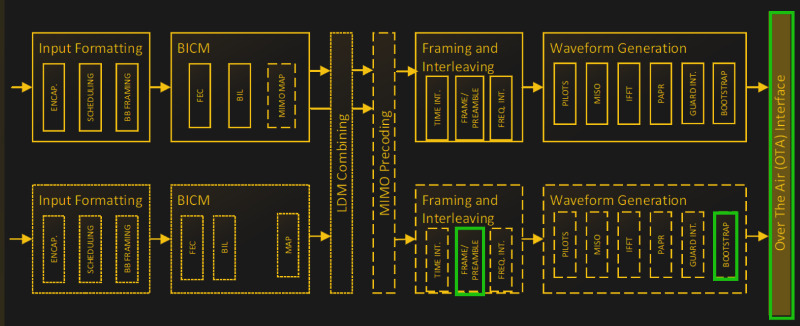
If you read the slide deck, the real story is at the end in the backup slides. That shows the ATSC standard frame and how the preamble changes. The math is fairly standard stuff. You know where the stations are, you know what time they think they sent the signal, and you can estimate the range to each station. With three or four stations, you can get a good idea of where you must be based on the relative receive times.
The stations diversify their time sources, which helps guard against spoofing. For example, they may get time information from GPS, the network, a local atomic clock, and even neighboring stations, and use that to create an accurate local time that they send out with their signal.
Learn More
Most of the slides come from more detailed white papers you can find on the NAB website. A lot of the site is dedicated to explaining why you can’t live without GPS, but you can’t depend on it, either. The bottom right part of the page has the technical papers you’ll probably be more interested in.
GPS is an impressive system, but we know it needs some help. BPS reminded us a bit of LORAN.


There are also other System under development, especially in the maritime domain. E.g. https://www.r-mode-baltic.eu/
Interesting, but wouldn’t this require a fair amount of geodiversity between the transmitters? In my Colorado location, the vast majority of broadcast stations are on one of 2 mountains, about 100 miles apart.
Same here in Connecticut, albeit on two towers. All the ATSC 3.0 broadcasts are from one of the two towers.
Yeah, on slide 9 they mention one of their criteria for the maps is transmitters separated by at least 1km.
GPS has the big advantage that it is available globally. So developing receivers for many different applications pays off easily. This enabled cheap receivers for everyone.
TV broadcasting uses different bands and standards throughout the globe, and there is a constant evolution going on (DVB-T, DVB-T2, DVB-T2 HD,…), with a constant change of bands, encodings and whatnot. This means a receiver will either just work in one region or be complex and expensive to cover all the bands and standards. And it is very likely that you will need a big redesign in a few years to cover some new standards. Not an economically attractive position.
So unless there is a big uptick in GPS jamming, I fear there won’t be an easy fallback available soon outside of niche applications with deep pockets and strict requirements like aviation and maritime.
(Forum messed that up.)
“unless there is a big uptick in GPS jamming”
Ahem: https://gpsjam.org/ For me, it centers on the Baltic Sea. Lots of not green cells.
But basing an alternative on commercial TV seems less than ideal.
I have long felt dropping Decca and Loran for only GPS (& co) was a bad idea.
Loran all over again.
Except that it requires a vastly more complex receiver and decoder to be useful.
I have a vastly more complex receiver and decoder in my pocket right now.
Aren’t all the transmitters shutting down because everything is moving to the internet?
If GPS goes down in an area or has a systemic failure, ATSC 3.0 based timing and positioning probably will go down as well as they’ll probably be using GPS at TV transmitter sites for timing.
Actually yeah, how do the broadcasters sync without a gps clock?
How did they do it before GPS?
Back in the analog NTSC days, we didn’t sync anything — fade local to black, switch to network with different sync and let the picture roll resynch happen, fade up from black.
As Isaac mentions, the sync needed in the days of NTSC was video sync. It wasn’t providing time services to receivers, it was needed when switching between video sources that were at different time points in the video signal, and it was needed in the studio, not at the tower. NTSC was specifically designed for cathode ray tube TVs which required scanning from left to right, top to bottom, hence the horizontal and vertical sync signals. ATSC is digital and uses MPEG encoding of the video and doesn’t require constant linear transmission of the picture like NTSC.
Presumably it could be done with NTP / PTP over the Internet but I doubt they’d get 100nS accuracy. Another solution might be using a rubidium clock that can be free-running for a period of time during GPS outages.
Slide 10 outlines many possible timing sources, with a recommendation for redundancy. GPS can be used as an augment for additional time sources.
They will probably have a rubidium frequency standard at the transmitter. It would be stable enough that a GPS outage won’t cause any issues for quite a while.
Yep. This is what the standard proposes. Pricey.
I’m trying to imagine a scenario where GPS goes down and at least for direction/location finding I’m totally lost. I mean, honestly, how often do you not have any idea where you are? I get it, there are military applications, and certainly the time-discipline of GPS is helpful. And backup systems for enterprise scale users is necessary. But did every average Joe forget that there was a time before GPS? I’m really showing my age I guess. But it isn’t hard. Get on freeway, go 85 miles, get off at the blah blah exit, turn left? Maps? Like paper ones? I even managed to do significant backcountry excursions with compass etc .
You’re in an airplane, in “the soup”, shooting a non-precision approach to an airport. Yeah, I’d like GPS, please. Especially since they went and decommissioned all of the NDBs and plan to do the same for VORs.
Some will be maintained. See VOR MON program. But this is mostly for commercial traffic, as the station usage is intended for above 5000AGL.
The trouble with your imagination is that you clearly have a sense of direction. I have one too and it astounds me when I meet people without one, but they exist and they aren’t necesarily idiots. I have a friend I consider a very intelligent person, but within 2 turns he couldn’t tell you how to get back to where we started. Personally I struggle to imagine how people like that ever survived without GPS.
It gets worse when you think about how much of our food supply chain is completely dependent on GPS, in hardware, without any backup mechanisms.
same here, though i confess to having a philosophy of “you can never be lost if you don’t care where you are”. you never know what you may find. I enjoyed bushwacking in the mountains or going from western NY to myrtle beach by heading south and a little east and ny to az by going south and quite a bit west wo maps (or did anyway when younger) GPS was not built for me though :-) there seems to be a lot of people that can’t find the store 20mi away without it.
People used to survive without GPS, and we could again if it made sense, but lots of things are better with it, and it’s objectively silly to refuse those benefits while they’re available.
And location-aware smartphones aren’t just a more convenient form of maps and compasses anyway. They also integrate maps with traffic reporfs, phone books and yellow pages, which means for example that you can run a knitting shop or a family restaurant without having to pay for downtown commercial real estate. Whether it’s good or not, many people’s livelihoods now depend on everyone having GPS.
“estimate your position within about 100 m”?? The GPS in my cheap phone can tell whether I’m walking on the sidewalk or in the road next to the sidewalk.
My first thought was that this seems like a lot of extra work. Everyone knows the commercials come on at the same time on all the stations. So display each station, use OpenCV to detect when the commercials start on each channel, from the time difference of arrival calculate your position, and Bob’s you uncle. Easy.
On a slightly less whimsical note, I wonder if you could train an AI with data recorded from an SDR and the corresponding positions and then use that to predict you location from the radio environment? (That’s gotta be worth some grant money for a graduate student).
Nope. You can’t rely on the timing of the regular TV content for doing triangulation.
The issue is that the regular TV content is sent from the TV station via fiber or microwave link to the TV towers and these links have different delays in a scale that it matters for this application, like microseconds. Also they have jitter due to the digital compression being done and using variable bitrates. This compression is not only done once for all towers a TV station sends from. It is done each time the TV program is combined with the other TV programs that send from the same tower (“Bouquet”).
For any meaningful location precision the timing signal must be embedded on-site of the actual transmission tower.
For accurate positioning using cell phone towers would be better. At least in my country the coverage is much better than with DVB-T2.
Yes, this could work well. The cell phone towers already must have a high-precision clock on-site for coordination among them and triangulation in emergency cases.
Also the standards used (4G, 5G,…) are the same world-wide and cell phone modems a commodity building block available from many companies. Most of these already have GPS embedded nowadays. So it would be relatively easy to extend the firmware on them to provide a transparent GPS fallback via cell phone tower triangulation in case GPS is jammed.
The timing signal could be sent unencrypted (but signed), so you could use not only the cell tower of the carrier you are subscribed to for triangulation, but also the cell towers of other carriers in the vicinity.
So I’m wondering why they don’t extend the mobile standards with something like this.
I imagine the “indoor” aspect is an important quality.
Cell service in my suburban home in a developed country (Australia) is spotty since the shutdown of 3G. But I can get decent digital OTA TV using a coathanger as an antenna. Once you get out of bigger towns the cell service is even worse.
This requires accurate time at each station. I have been monitoring the time data sent by my local (DFW) stations for years and not one has ever met the +/- 1 second requirement in the ATSC 1.0 standard.
if you have three towers that know eachothers perminant locations. Those towers can sync with each other because they know the distances. These three towers don’t need to be in sync with any real time clock. They just need to be in sync with each other so that the client device can determine this distance from those group of synced towers in a region..
Why 4 and not 3 ?
Altitude, maybe?