

Navigation is easy these days, as we’ve entire complex computerized mapping systems and radio-based positioning systems to find ourselves anywhere on Earth. It might seem simple to use GPS these days, even trivial, but billions of dollars are what it took to make that happen.
Back in the day, navigation was simpler, and cheaper, using a handheld device and natural objects in space instead of artificial satellites with atomic clocks. Let’s learn about the sextant, and how it did its job.
Navigational Tool
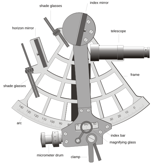
For most of human history, getting lost at sea was a very real way to die. Coastlines can be followed and landmarks recognised, but once the land drops below the horizon, a crew has little more than dead reckoning to go on. You can estimate of speed, heading and elapsed time, but errors pile up the longer you go without a concrete reference as to where you are. When land is out of sight, the sky can offer that very reference point, but you have to be able to measure it accurately enough.
That’s where the sextant comes in. It’s a deceptively simple instrument that is, paradoxically, somewhat difficult to understand at a glance. It’s little more than a frame, a pair of mirrors and a small telescope, which lets a navigator measure the angle between a celestial body and the horizon to a tiny fraction of a degree. Take that measurement at the right moment, work through a few tables referencing the detected angle and the time of measurement, and you’ve got your position on the globe. The sextant was predated by the octant, which dates back to the 1730s in implementation—specifically at the hands of John Hadley and Thomas Godfrey, though Isaac Newton had described such a device in unpublished papers sometime earlier.
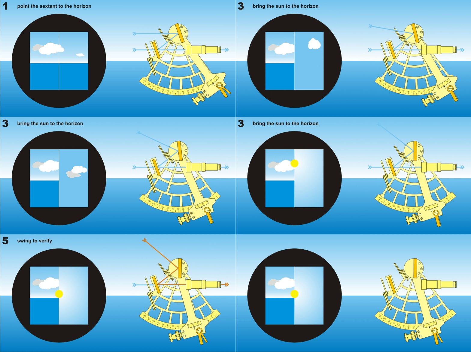
The sextant is so named for being a “sector,” an arc tracing out 1/6th of a circle. That 60 degree arc can actually measure angles up to 120 degrees, thanks to the principle of double reflection. It was this that separated it from the earlier octant, which only measured angles up to 90 degrees, making certain measurements more difficult or impossible to take. Light from a targeted celestial object, such as the Sun, bounces off a mirror mounted on the swinging index arm, then off a second, fixed horizon mirror and into the telescope. The horizon mirror is traditionally only half silvered, so the navigator sees the real horizon through the clear half and the reflected Sun or star in the other, side by side in the same view. The index arm is rotated until the object appears on the horizon, it’s dialed in perfectly with a fine vernier measurement, and the scale can then be read off to learn the angle between the two. Notably, a sextant will typically include several shades to place in front of the mirrors, allowing the Sun to be viewed through the telescope without risk of eye damage.
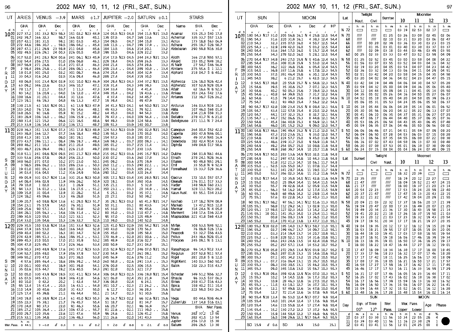
By looking up the angle between a celestial object and the horizon, and the time of measurement (in GMT) in a nautical almanac, it’s possible to determine one’s latitude and longitude with a bit of maths. Depending on where you are and the prevailing conditions, it’s possible to measure the angle of the Sun, the Moon, or various stars, and cross referencing these with the right tables will let you figure out your location. Most sextants typically include a vernier that will allow measurement down to 0.1 minutes of angle, or 1/60th of a degree. With one minute equal to one nautical mile, the theoretical best achievable accuracy is down to about 0.1 nautical miles when positioning with a sextant. Realistically, a highly experienced navigator could determine position within 0.25 nautical miles or so, though for most purposes at sea, getting within a few nautical miles is plenty good enough such that visual navigation can take over.
A sextant is just one piece of the puzzle when it comes to determining position at sea—you also need to know the exact time of measurement, and have an almanac to consult to translate the readings into latitude and longitude. Techniques differ depending on the celestial objects you’re using to navigate. However, with the simplest techniques and a bit of quick maths, it’s surprisingly straightforward to find a reasonably accurate positional fix with a sextant.
One neat aspect of the sextant is the mirror arrangement that makes it usable on the heaving deck of a ship at sea. Because the horizon and the target celestial object are seen together, the ship’s motion moves both images at once, and the angle between them stays put. For example, the navigator brings the Sun’s lower edge down by adjusting the instrument until the image just kisses the horizon, rocks the instrument gently to make sure the sextant is being aimed truly vertically, or lets the gentle motion of the waves do the same, and then the measurement is known good.
Taking measurements with a sextant aimed at the sky is tedious by modern standards, particularly when it comes to cross-referencing tables and pencilling out the numbers on paper. It’s obviously much faster these days to look at a moving map display on a modern GNSS system, and more accurate to boot. However, such systems are not infallible, and are subject to jamming and all sorts of other nonsense in a way that the sextant just isn’t. Hence, this relatively traditional navigational aid remains in use even with modern navies, as a standby when the modern hardware can’t do the job.
The sextant was a major technological advancement in the 18th century, with greater navigation aiding merchant mariners and navies alike. It would be some time before the sextant was bettered by more advanced navigational aids, and even today, it remains a perfectly useful way to navigate the oceans and the seas. It might not be in as common use as it once was, but if the lights ever go out or the satellites go down, a sextant will still get you where you’re going. Building your own isn’t even all that difficult!










Please be kind and respectful to help make the comments section excellent. (Comment Policy)