
I came across an interesting question this weekend: how do you establish your East/West location on the globe without modern technology? The answer depends on what you mean by “modern”, it turns out you only have to go back about three centuries to find there was no reliable way. The technology that changed that was a clock; a very special one that kept accurate time despite changing atmospheric conditions and motion. The invention of the Harrison H1 revolutionized maritime travel.
We can thank Andy Weir for getting me onto this topic. I just finished his amazing novel The Martian and I can confirm that George Graves’ opinion of the high quality of that novel is spot on. For the most part, Andy lines up challenges that Mark Watney faces and then engineers a solution around them. But when it came to plotting location on the surface of Mars he made just a passing reference to the need to have accurate clocks to determine longitude. I had always assumed that a sextant was all you needed. But unless you have a known landmark to sight from this will only establish your latitude (North/South position).
Watching the Sun
If you’re standing still, you can plot the location of the sun in the sky each day. If you move West from that point, the Sun will be lower in the sky at the same exact time because your new location takes longer to move toward the horizon line. Knowing this and combining it with sextant readings lets you easily calculate your exact position. But you need a very accurate clock to make the first measurement.
![One of the earliest Pendulum clocks built in 1657 [Source: Rob Koopman CC-BY-SA]](https://hackaday.com/wp-content/uploads/2015/09/christiaan_huygens_clock_and_horologii_oscillatorii.jpg?w=800)
John Harrison; The Legend
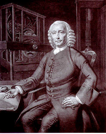
This guy is our guy. You have to sympathize with someone who spent 31 years of his life trying to solve a really important problem, killed it with his invention, and was only marginally recognized for the accomplishment.
His first stab at a maritime chronometer started in 1730 and resulted in the Harrison H1 which was given a sea trial in 1736. It wasn’t the very first clock designed for a ship, but it did overcome the problems faced by earlier designs.
First off, you can eliminate many of the problems of pendulums by using a horizontal balance wheel. Balance wheels had already been tried and were proven to be imprecise, especially because of changes in temperature affecting the metal spring used in the system.
The H1 used a novel approach that fixes almost all of the issues. In it, Harrison implemented a double beam system. The two were mounted in a vertical position with the pivot in the middle and weights at both ends. These oscillate opposite of each other and have springs on both ends that pull them toward the center point of the chronometer and push them back out again. This continued shift of momentum is not affected by the motion of the ship or by changes in atmospheric conditions.
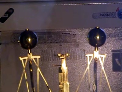 You can see the top weights of a replica H1 shown to the left. This is a screen capture from a very quick clip video showing the clock in action at the Royal Observatory in Greenwich. Take a look and you’ll get a glimpse of how large the device is.
Although the H1 worked extremely well in many cases, it was still vulnerable to centrifugal forces and tested rather sporadically. He refined the design twice and by the time he built the H3 in 1759 it included more balancing weights to combat this weakness.
But in the end the entire design was scrapped for a huge leap forward which would become the standard for mechanical watches. It was back to that horizontal balance wheel and spring that proved the ultimate solution. Harrison solved the problem of temperature swings killing accuracy by using a bimetal spring that adjusted its own tension as it warmed or cooled. He also increased the speed of the balance wheel to improve performance. This was realized in the H4 which was completed in 1761.
But don’t forget that I mentioned his discovery was somewhat marginalized. One contributing factor to his drive to solve the issue was the Longitude Reward the British Government was offering. The H4 qualified for the highest prize of 20,000 pounds sterling (2.8M at modern value) because it achieved accuracy of less than 30 minutes of longitudinal error. The Longitude Board, which was responsible for making the determination of a winner, asserted that he had to produce multiple copies of the H4. He eventually received the full reward… about 36 years after the first copy of the H4 was shown to be reliable. Better late than never, although the then 80-year-old Harrison might not have been so upbeat about it.
We’re Still Using Clocks for Navigation
It would be really interesting to know Harrison’s reaction if we were somehow able to explain today’s navigation practices to him. Obviously we’re not using the H4 to navigate our ocean-going vessels. Modern ships are simply incredible. They have highly advanced navigation and control systems; they even include automatic pirate detectors (arg!). But boats, cars, and your smartphone alike are all still using extremely accurate clocks to get a perfect fix on your global location.
GPS, the Global Positioning System, uses time to triangulate between satellites. There are 24 satellites in the GPS system each with 4 atomic clock sources (Rubidium or Cesium). A GPS receiver locks onto satellites, receiving a chirp from each that includes a time stamp from their clock standard. If you don’t already know how this works you need to watch Grace Hopper’s explanation of how far a nanosecond is. When you’re talking about distances like those from an orbiting satellite to the earth, the speed of light comes into play big time. Calculate the amount each satellite timestamp is off from each other and you can triangulate your location in 3D space: latitude, longitude, and elevation.
We’ve far surpassed the Harrison H4, but clock accuracy has never been more important for finding our way.


There is another way as described by Gavin Menzies in his book 1492 (not endorsing – it’s a controversial book). Menzies asserts that the Chinese were using lunar eclipses to determine longitude in the 15th century by noting what stars were at the zenith during the various phases of an eclipse. Since the eclipse happens at the same time no matter where you are, you can grok your longitude by knowing the offset between the stars at zenith at the two locations. Not exactly real-time, and useless for navigation. But still cool. I thought about noting the zenith last night, but didn’t bother.
does that also work for magnavox?
(sorry) ;)
The Nova episode on this topic did mention using the eight sky, but also mention even if it wasn’t overcast the rocking of the ship at sea made it difficult to get the sighting the need, and if the did gt the sighting, the math required took a very long time. Meaning by the time they fixed their location they would have been well beyond that point
A competing entry for the longitude prize was the marine chair, a gimbal-stabilised chair that would let an observer take sightings from stars without being as affected by the motion of the ship. See http://cudl.lib.cam.ac.uk/view/ES-LON-00026/1
Even after Harrison’s chronometer, astronomical events (especially transits and occlusion of Jovian moons) were used to correct chronometers during long voyages, or in those rare instances where the punishment of lashes didn’t prevent a seaman from letting a ships chronometer from winding down…
Harrison was a real genius. And they just barely paid him after a lot of wrangling. Interestingly, I read somewhere that gears, at least in the 1st version, were made of wood.
They were wood, but wood chosen for both its hardness and self lubricating nature. The older H series chronometers still work today. The H4 was made from metal, and the acids in oil mean it doesn’t work any more.
There is a great PBS Nova episode about the Longitude Reward and Harrison. It’s worth the watch.
Har har har.
IIRC, the name of the show was “Longitude” it also starred Jeremy Irons as a man who centuries later worked to renovate the Harrison clocks. I was surprised to hear them pronounce Longitude with a “hard g”. The movie is available on the PBS store.
I have only ever heard the hard “G” version in England.
Longitude (/ˈlɒndʒɨtjuːd/ or /ˈlɒndʒɨtuːd/, British also /ˈlɒŋɡɨtjuːd/)
We Yanks (i.e. Americans) say “lawn-jah-two-d” for longitude. Brits (i.e. UK) say a lot of stuff weirder to our ears like “shed-jewel” for schedule. Why don’t they say “shoe-el” for school? We say “skool” just like they do. I love it when they try and imitate our accents like we all have Boston or Texas accents right? I think actor Idris Elba is one of few Brits that can do our accents correctly. Jeremy Irons doesn’t usually try to but he’s not to good at it either. I think he sticks with his own accent when acting.
Don’t forget Hugh Laurie, as a Brit who can do a perfect version (so I’m told, not a native speaker myself) of American English.
And watching the occultations of Jupiter’s moons with a telescope can get you to within a minute or so.
That was used before good clocks. But hard to use on a pitching ship.
True but you’d need a lens at least with 2.75″ aperture and 50X magnification. Binoculars like that are rare. A T-scope like that would need to be on a tripod or deck gimble-mount. Of course, like you said, any pitching and yawing would negate your efforts. I think shooting LUNA would be easier (i.e. Lunar chronometer method with sextant). I wonder if an Arduino with a home made sextant could be programmed to equivocate that method. Or a homemade automatic web cam lunar tracker. Initially aim it at moon and it tracks the moon’s movement. It would use 2 linear potentiometers to read azimuth and elevation into a ADC to the Arduino. The motors would be stepper motors. Or maybe steppers would not need position feedback? Just brainstorming here…
There’s a great book that tells the story
http://www.amazon.com/Longitude-Genius-Greatest-Scientific-Problem/dp/080271529X
It’s a great tale of competing methods of determining longitude. The establishment did not like the solution of the hacker.
I was about to leave the same comment. What an amazing book and story.
Another hero in this is Nathaniel Bowditch. He compiled “The American Practical Navigator” in 1802, a book that is still updated by the USCG and continues to be in print. This book provides a foundation for celestial navigation and was used to teach generations of navigators with little formal education.
Celestial navigation is still used in military roles via computer vision when the prospect of GPS being jammed (such as the retired SR-71) would prove problematic to the mission.
The PDF is available for free (as it’s maintained by taxes) and worth having in every hackers library. ftp://ftp.flaterco.com/xtide/Bowditch.pdf
And wiki format
https://en.wikisource.org/wiki/The_American_Practical_Navigator
Dead reckoning is what you do without any instrument readings, based solely on estimated direction, speed, and duration of travel. This is what robots and submarines do when they use their IMU to determine location (albeit less precise).
Navigators with celestial readings but no clock would use what is referred to as ‘parallel sailing’. That is sailing due east-west along a parallel (latitude) until landmarks or navigational aids are available to follow.
I’m sure subs use a host of tricks, not just IMU but there are many other things, like possibly variation in the earth’s magnetic field and such, which makes me wonder, is there any particle the sun emits that goes right through an ocean like neutrinos BUT are detectable in a usable manner? Because then you could locate the sun, which might be a handy aid.
I’m sure the US navy won’t tell but maybe somebody can reverse engineer, for lack of a better word.
Magnetometers are integrated into IMUs, Basically it’s a digital compass that adds precision to changes in course. But even these have their flaws since large ore bodies or underwater cables (power in particular) would influence them, forcing you to trust in your accelerometers.
Any particle that makes it through the atmosphere and a few hundred feet of water is either going to scream right on through a few tons of steel, or get absorbed by the hull. Placing sensors outside the hull to detect such a particle would introduce many engineering problems, that in general aren’t worth the effort since being able to detect the sun is less useful than knowing which way is north.
About those particles, some particles could be coaxed into reacting with specific setups. And combining the location of the sun with a precise clock will give you more info than a rough magnetic north.
As for those ores and cables, that is precisely the advantage, since there are variation in the magnetic field depending on the location it would actually aid you with determining where you are. If for instance you can detect an underwater cable, which is in a known locations, you automatically know you are somewhere along the line of that cable.
Ahh, I was thinking along the lines of how magnetometers generally function w/i the IMU. Being able to locate yourself on the map is important but if you’re navigating a submarine canyon and your instruments go nuts you’re in trouble.
Unless it’s been navigated before and you know to turn port 20*, bow up 5* when the instruments flip out.
@Leithoa – Here’s a scenario for you (use Gene Hackman’s voice) “COB turn to port 20°, bow 5° up bubble. Make your depth two five zero, hover, and float the buoy.”, “The comm-buoy skipper?”, “No that new KVH thermal-sun-tracker thing with the 500 foot fiber-optic cable we got at NLON last week during our IMU system’s retrofit… COB?!”,”Aye aye captain! Quartermaster,,, prepare for SolarShot deployment…”.
Of course there is no such thing but that would make for a great HaD project to sell (or give) to DoD SBIR or DARPA! It could even use an Arduino. It would have to by HaD tradition I think. 8-P
@Whatnot – Well SOLAR FLARES can penetrate seawater up to 33 feet. That’s within periscope depth. So maybe some sort of underwater SF detector could be invented and used by USN for emergency navigation? According to a hobbyists radio astronomer, the sub already has the equipment in the form of their VLF radio they use(d) for EAM’s. Some how the absorption of SF SIDs (Sudden Ionospheric Disturbance) can be detected on a VLF radio around 24 Khz. http://tinyurl.com/pzgubu7 (a PDF file)
At least modern NATO subs tend have very sensitive gravitational sensors, that allow them to detect fluctuations of the ocean floor without having to use sonar…
Also, very sensitive and complicated magnetometers, both for navigation and enemy subs…
@AKA the A – the latest USN super-sensitive magnetometer uses UV light…
@Whatnot – Leithoa is 100% accurate (as usual!). There is also the Laser Gyro Compass that does not depend on geomagnetics nor outside RF or photonic signals. It needs to be initialized at a fixed surface point though. USN uses some pretty sophisticated stuff too. The accelerometers they use (i.e. FOLA’s) are not from Radio Shack – LOL
Your neutrino idea wont work as they mostly go through everything. One thing you could do was have a huge vat (470 metric tons) of dry cleaning fluid (perc – C2Cl4) and maybe a argon proton or two might become visible as a neutrino passes by; but a submarine has no room for that *-) – There are other ways but all still too big for a sub.
(Just like it has no room for exterior screen doors either – LOL)
An ancient method of navigation needs to be reintroduced to science today. A piece of feldspar called Icelandic Calcite could be used to find the sun even at twilight when the sun has gone below the horizon. Also works during periods of overcast and precipitation (i.e. occulting of the sun). You use your fovea (in your eye) to peripherally detect a streak of light from polarized sunlight. Probably helped Lief Erickson in 11 century CE find North America.
Some insects use polarized sunlight for navigation: bees and ants – maybe others too.
Also the Polynesians used known ocean currents and other ancient maritime navigational methods (i.e. stellar, marine life behavior, meteorology, sea color, etc.) to trek out to remote places like Easter Island, Tahiti, and other Pacific islands. This even may account for pre-Colombian treks to North America. A theory says that the so-called Indians Columbus and other Conquistadors had first contact with may have actually been people with Polynesian DNA.
eot
I made it clear that I was aware that neutrinos won’t work, they merely served as an example that some particles have no issue penetrating the ocean, or in fact the entire planet. But my point was that there might be other particles that can penetrate a large volume of water but which through technical means would still be detectable in a sub.
And although a sub has little room, it does have a lot of electrical power if it’s a nuclear type I expect.
As for polarization, I’m not sure that would work at the depth moderns subs can travel. The photons if any are probably scattered or coming from bio-luminescence – if there are any. Although I guess you didn’t refer to use with submarines on that subject.
But your maria life and water color example is something that could aid even in a sub, I wonder if you could just combine a shitload of vague clues into a semblance of actual coordinates.
@Whatnot – OK duly noted about the neutrinos. They are working on something that uses Blue-Green-Ultraviolet light to penetrate seawater for something (not from sunlight but from an overhead plane, ship, or satellite).. Whatever it does is light-years way over my pay grade :-)
(Checkout QInetQ in UK. I think they are working on it for USN – I’m not talking about SLC comm either…)
Yes you are right I did not offer that information about Icelandic “sunstones” for underwater navigation. The sub would have to surface and use it to take a sun bearing. But sub’s wouldn’t need it with all the high-tech gadgets they have for navigation. I think they have a AI-based gadget that if they lost all power at sea (virtually impossible for a nuke), you could aim this palm sized thingy at the night sky and it would figure out where you are by stellar navigation. You don’t need to tell it anything as it automatically figures out which way is north, what time it is, and by pattern-recognition figures out constellations and individual stars and planets. Of course you need to put batteries in it. Of course you must be top-side for it to work too.
Regarding the Polynesians, I don’t think they thought like Westerners who need to know their EXACT COORDINATES. Just like how Europeans needed to OWN LAND in North America and the natives where going “Huh? What’s that?”. I think they were happy if they could come within spotting distance of familiar landfall when traveling the Pacific. I imagine a AI-based computer program could take a “shitload” of diverse data like that and come up with a close approximation of your global position at sea. Sounds like a good HaD Arduino or Raspberry PI project? 8-D
They still teach PN somewhere in South Pacific. Here are some references to literature on it:
* Kawaharada, Dennis. “Wayfinding: Modern Methods and Techniques of Non-Instrument Navigation, Based on Pacific Traditions”. Wayfinding Strategies and Tactics. Honolulu, HI, USA.
* “Wayfinding”. Honolulu, HI, USA: Polynesian Voyaging Society.
* Exploratorium. “Never Lost | Polynesian Navigation”. San Francisco, CA, USA.
If you’re looking for modern navigation, HFOS might be interesting for you. It won’t really work without a clock either, but what does, these days ;-)
It strives to be a very collaborative crew/ship management system with open charts and a lot of “multiplayer” goodies.
One of the most important things it aims to do, is bring the navigation desk to the crew’s pockets – BYOD-style.
Another point is to aggregate sensor data to collaborate back to the open sea map and other open datasources.
HFOS lives on your ship computer (aimed for embedded hardware) and loves if you have Wifi on your vessel already, but you can use it on your localhost, too – the frontend is built with HTML5, the backend constructed in Python. The sourcecode lives on github: https://github.com/Hackerfleet/hfos
I am the developer. AMA ;)
You need better SEO, lol ;)
You seem to have lost your domain name (hackerfleet.org) to squatters. Might be a good idea to update your info on github: https://github.com/Hackerfleet
Thanks for the headsup, that should be “fixed” again – we’re working on a new homepage.
@riot – Technically even GPS won’t work without a local clock too. It must be set correctly before you use it. The satellites use a clock too but way over our pay grade they are… ATOMIC
The satellites’ atomic clocks also have to be regularly updated to correct for relativity: they’re far enough out of earth’s gravity well and have sensitive enough clocks you can actually observe their clocks running fast relative to an earthbound clock.
@drew – That’s pretty much the reason why serious TIME MACHINE advocates like physics professor Dr. Ron Mallet at UCONN.edu (and others) refuse to give up the notion that time-travel is possible. Dr. Mallet claims he has successfully sent a gauge boson BACK 1-second in time using a ring laser and photonic crystals. I’m still very skeptical even though I have visited the location a few times. His supervisor says he is very serious about it and is not some crack-pot. The jury is still out I think on that. Ken Olum and Allen Everett say he is wrong: http://arxiv.org/abs/gr-qc/0410078
I still haven’t read his book on my shelf yet. I wish someone would read it to me… (LOL)
There’s one with wooden gears that’s still operational. From Wikipedia:
“In the early 1720s, Harrison was commissioned to make a new turret clock at Brocklesby Park, North Lincolnshire. The clock still works, and like his previous clocks has a wooden movement of oak and lignum vitae.”
Yes, Lignum vitae is an “oily” wood.
Yes- that is for real. It was stopped once, I believe, sometime in the 1880s I think, for basic service.
The thing is STILL RUNNING. Accurate too. To call Harrison a genius is almost an understatement- there are people working nearly 300 years after his death that still can’t make a clock that can run that long or accurate.
The guy was a god of horologists, the only man among horologists that makes even A.L. Breguet look small by comparison. They still haven’t figured out how he formed the curved planes of the diamond pallets for the H4.
For those interested- and to further prove the point that this man is equivalent to Einstein in the world of horology, he designed a clock before he died that was never built- but he claimed it should keep time to within ONE SECOND in 100 days- using a pendulum. Keep in mind- this is an insane feat even to this day. It really shouldn’t be possible.
Martin Burgess, a Brittish clockmaker, replicated Harrison’s design recently- Google Burgess B Clock. It really did work- and it is now in the Guinness Book Of World Records for most accurate mechanical clock ever made.
It was designed over 250 years ago. Design existed- but no maker ever made a clock near that accurate, without aide of something electrical. It’s totally mechanical.
It’s not hyperbole to say John Harrison is the horological equivalent of Einstein. Genius is too small a word for some people- Harrison is one of them. Long after he’s dead- he’s still reinventing our understanding of timekeeping. And his story is one of the best reads you’ll ever pick up. The guy was absolute tenaciousness incarnate.
What did Einstein ever invent with his hands? Just asking…
A fridge.
https://en.wikipedia.org/wiki/Einstein_refrigerator
@tag – Actually according to Gene Dannen of Scientific American, he says his Hungarian student Leo Szilard did all the “hands-on” work and Albert just did the paper work for the patent applications. Just saying…
You know in 100 years from now robots will be making the same bitchy comments about humans.
Einstein’s mind was a much better tapestry than physical space for his ideas. I think if he was too focused on classical mechanics he would have never redefined them using non-euclidean geometry. He was able to look at what everyone else saw and say it was not accurate just by knowing that it wasn’t pretty enough to be true nature. He literally redefined reality in a time when physics as a science was in its infancy. Its truly comparing apples and oranges but I glorify the complete redefinition of time over building a badass clock before its time.
You can easily navigate today without (carrying) modern instruments or a compass. For example, to got to Hawaii from Seattle, go out the straights and head for the setting sun a day or two. Turn South till your butter melts then follow the jet contrails from LAX to Honolulu. Your passengers will first be panicked and then amazed at your navigation sense.
You don’t even need the butter if you do a statistical analysis of the changes in the passenger’s clothing choices, except this is not very popular with most captains on account of the requirement that they do not skew the results by attempting to disrobe any of the passengers themselves.
Polynesians had no trouble navigating between Hawaii and mainland North America. Just used sea color. bird behavior, ocean currents, cloud formations, and apparent star movements. Also the ancient Japanese fishermen had no trouble navigating to Peru (albeit mostly by accident). The ancient Chinese (under first emperor Qin Shi Huang) supposedly trekked to California coastline and interacted with local Natives there many centuries before Columbus (just circa 220 years before Jesus Christ’s birth in Israel).
If you are ever in DC, visit the Time and Navigation exhibit at the National Air and Space Museum. They also have a good online version that goes into the the history of maritime navigation – timeandnavigation.si.edu/navigating-at-sea
If any of you ever get a chance to go to England, you’ll probably be in London. The Royal Observatory in Greenwich is right next to London. It’s the place where the Prime Meridian is measured from.
If you can, absolutely go see it. There is simply no place else like it in the world- and it has one of the world’s most impressive collection of timekeepers. Harrison’s H1, H2, H3 are there, and a replica of the H4 is on display. The Worshipful Company Of Clockmakers guildhall in London has an incredible museum too.
I went to school to learn watchmaking, and going to that museum and seeing Harrison’s pieces, actually before I realized their true importance, was what made me want to be a watchmaker. The entire place was a huge inspiration, and one of the coolest places you’ll ever visit if you are a fan of timekeepers, mechanics, history, or geography. Students today still learn about Harrison in modern curriculum as watchmakers- he was simply that important to our modern era.
Greenwich was the Prime Meridian, by definition and by International Treaty. Today latitude and longitude is defined by reference to a mathematical model of the, slightly lumpy, Earth, not to any physical place on the Earth. There are lots of mathematical models of the Earth (or regions of the earth) and they all differ slightly. Google Earth can zoom in to show the Prime Meridian carved into the pavement at the Greenwich Observatory, and it marks 0° as being a few feet away. Both the groove on the ground and the Google 0° line are correct.
It is odd that now we have astonishingly accurate means to measure our longitude and latitude the definition of latitude and longitude is imprecise unless we specify which model we are referring to.
….and congrats ladies & gents, we’ve been slashdotted. The only other site I visit daily. I’m honored I posted here. Never thought John Harrison would get slashdotted, but I think he’d like it.
Great movie on Harrison, the quality is a bit rough though
https://www.youtube.com/watch?v=Ykl2RleVTy8
As I recall, one of Darwin’s task on the Beagle was to wind and tend to the chronometers (plural, since you would not want to trust your longitude to a single, malfunctioning unit).
If you had 2 clocks, you’d be more confused than if you had just one.
Lewis and Clark used a Thomas Parker Chronometer (cost $250.00) for their maps. Sadly, they often forgot or were too busy to keep it wound. It was found to lose 14 seconds in 24 hours each day after initial calibration. When found stopped, they had to resort to celestial sightings to reset the clock.
@MonsieurET – No worries mate… Sacajawea,their Lemhi Shoshone assistant, probably knew her way anyway. We NA’s seem to have a natural instinct for navigation. I’ve never been lost anywhere until I went to Camden NJ or Waterbury CT (two of the worst planned cities ever!). California is very easy to navigate without instruments. Mexico and Canada also no challenge for NOT getting lost. NYC is a piece of cake when you get the numbering plan straight in your head. In Lewis & Clark’s situation, even applies today, if you ever get lost in the woods just follow any river downstream. You’ll run into somebody (or some animal) eventually as every creature needs water. And humans tend to build villages. towns. and cities next to rivers.
What really astounds me is that they brought an almost silent-firing air rifle along and amazed the NA’s! I still can’t see how the inventor did that. Much better than a musket.
It looks like a bomb.
http://www.theambler.co.uk/wp-content/uploads/2014/06/Simon-and-Phil-Derry.jpg
Phil Derry, Commodore of Coquet Yacht Club (coquetyachtclub(dot)co(dot)uk) is a direct descendant of John Harrison. He and his son Simon continue the entrepreneurial lineage with their location company trackaphone(dot)com. Their technology enables them to pinpoint and track the exact location of any individual and asset across the globe. Phil said “John Harrison was my (times 6) great-grandfather on my mother’s side. From what I have read about him, I am sure my son has inherited his disposition. He has the same stubbornness and attitude towards quality and attention to detail.”
Remove (dot) and replace with period to go to websites
http://strongbrains.com/images/harrison.jpg
Notice the family resemblance between Harrison and Commodore Derry above…
Awesome link thanks!
Not to nitpick, but GPS uses trilateration instead of triangulation.
I don’t mean to nickpick, but GPS uses trilateration and not triangulation.
@rotatetechnology – Correct. Much the same way LORAN-C navigation systems worked. The computer is measuring the distance along a hyperbolic line of the RF signal (oversimplifying it of course – the GPS process is very complex). Radio triangulation would be measuring the azimuth in degrees to an RF source from your point.
I would love to know who invented GPS and the evolution of thought leading up to it. NEVER MIND it was Roger Lee Easton, Sr. who died last May… :-(
They did longitude and latitude doing different purely mechanical methods on that show Rough Science.
Clearly most of these comments are irrelevant. The principal contender for the royal prize was the method of lunar distances proposed by Sir Nevil Maskelyn, the Astronomer Royal. Although Harrison won the prize, most mariners used “lunars” because chronometers were extremely expensive until the 20th century. “Lunars” required only a sextant and the navigational almanac’s tables and the calculations are surprisingly easy to do. Since every navigator had a sextant and the tables anyway it was much cheaper to do “lunars” than a “time sight. Sights from the deck of a vessel at sea are not particularly difficult except for the requirement that you use both hands to adjust the sextant and have to hang on to the boat with your teeth or wrap your self around a shroud or a stay. As mentioned two chronometers that disagree are as bad a no chronometers. Royal Navy warships carried three. For an explanation of how to do “lunars” see Chapter 8 in “Celestial Navigation in the GPS Age” by John Karl. Joshua Slocum sailed around the world alone and his only timepiece was a tin alarm clock without a minute hand. LUNARS RULE!!