Those who fancy themselves as infrastructure nerds find cell sites fascinating. They’re outposts of infrastructure wedged into almost any place that can provide enough elevation to cover whatever gap might exist in a carrier’s coverage map. But they’re usually locked behind imposing doors and fences with signs warning of serious penalty for unauthorized access, and so we usually have to settle for admiring them from afar.
Some folks, like [Mike Fisher] aka [MrMobile], have connections, though, and get to take an up close and personal tour of a couple of cell sites. And while the video below is far from detailed enough to truly satisfy most of the Hackaday crowd, it’s enough to whet the appetite and show off a little of what goes into building out a modern cell site. [Mike] somehow got AT&T to take him up to a cell site mounted in the belfry and steeple of the 178-year old Unitarian Church in Duxbury, Massachusetts. He got to poke around everything from the equipment shack with its fiber backhaul gear and backup power supplies to the fiberglass radome shaped to look like the original steeple that now houses the antennas.
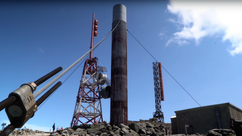
Next he drove up to Mount Washington in New Hampshire, the highest point in the northeast US and home to a lot of wireless infrastructure. Known for having some of the worst weather in the world and with a recent low of -36°F (-38°C) to prove it, Mount Washington is brutal on infrastructure, to which the tattered condition of the microwave backhaul radomes attests.
We appreciate the effort that went into this video, but again, [Mike] leaves us wanting more details. Luckily, we’ve got an article that does just that.


You can get some nice apps on Android that give you extra information about the cells you’re connected to, and where they are. Dunno how much practical use they are, but that’s not why I wanted them.
War driving cell towers maybe?
I know some like to know what repeaters are in their area because there are classified activities that have been exposed like Stingray and I’m sure worse acts. I think they need to come out with why there isn’t the old radar installations like we can still find say in Sault St. Marie AFS FPS-35 Radar Tower and elsewhere. Man, that would be an awesome antenna to have working.
Maybe there are applications like the “Walabot Review – RF Radar / Imager / Sensor Development Kit” details that we don’t know about.
>> Those who fancy themselves as infrastructure nerds find cell sites fascinating. They’re outposts of infrastructure wedged into almost any place that can provide enough elevation to cover whatever gap might exist in a carrier’s coverage map.
The cell towers make up the coverage map, (I suppose bu definition each fills a hole in the coverage map), though I think when you wrote this you were thinking of femto cells – the ones that are able to amplify a weak provider signal in a very small area.
If you read that sentence as “… whatever gap might OTHERWISE exist in a carrier’s coverage map” it makes more sense.
Mr. Mobile might want to check his climate facts for Mount Washington, see this Wikipedia article: https://en.wikipedia.org/wiki/Mount_Washington_(New_Hampshire). The 231 mile per hour wind gust recorded on April 12, 1934 is the highest ever recorded by man. On April 10, 1996 an automated weather station recorded a 254 miles per hour wind gust during a tropical cyclone. Unlike the #2 Heated anemometer which recorded the 231 mph record and can still be seen in the Summit museum and it’s calibration tested the automated instrument that recorded the 254 mph record was never recovered to have it’s calibration checked. As far as the -34 F record recorded in December of 2017, that was a daily record and not an all time record which stands at -50 F recorded on January 22, 1885.
Mr. Mobile didn’t need to trade in his rental car for a train ride up the Cog Railroad as the summit can be easily reached during the summer months via the Mount Washington Auto Road which is a 7.6 mile toll road up the mountain. The trip generally takes 30 to 45 minutes although Travis Pastrana made the trip up the 7.6 miles in 5:44:72 in the summer of 2017 without the assistance of a co-driver breaking David Higgins previous record of 6:09:09 set in the summer of 2014.
If you like this kind of behind-the-scenes stuff, this video from Dave Jones at the EEVBlog showing the insides of a TV transmitter is well worth a look:
https://www.youtube.com/watch?v=mR_wJkxKSXU
If towers make you drool, join the club… er… group.
Search Facebook for group: “I Take Pictures Of Transmitter Sites”
I have a friend who is responsible for the technical operations of a group of TV and radio stations. Trips to his work are always educational and fun. He also has working relationships with cell, two-way and microwave providers. The amount of working equipment they discard as “obsolete” is astonishing. Needless to say, many of these guys are electronics nerds and/or ham radio guys, and some of this equipment finds new applications in ham radio. There’s a lot of cross-fertilization that goes on. Fascinating industry.
If you go on eBay, you can get refurbished rubidium oscillators reasonably inexpensively. My understanding is that the glut of those is the result of salvaging them from the last generation of cell site equipment.
Yeah, sticking money out in the middle of nowhere. Locks, keys, and signs indeed.
According to legend, somewhere in the Miami area there was a community that had almost no cellular coverage.
The problem continued because the community would not grant a permit to put up a tower in the area. One of the “Major Players” purchased a house in the community, gutted it, and installed a cell site in it. Apparently, the property is immaculately cared for, but the curtains are always drawn, and the only vehicles that ever park in the driveway are maintenance techs.
Now, I don’t know how true it is, but when I worked for various cellular carriers, Bell Atlantic/NYNEX, Cellular One, SBC Cellular, and Nextel, eventually some old timer would make mention of it, and the story was always almost the same.
I’m surprised the NIMBYs still didn’t have a cow, crying about the specious risks of non-ionizing radiation.
I’m sure they tried to keep its existence a secret.
BTW, cities hide pumping stations in fake houses to keep peace with the neighbors.
You know this almost sounds like a dare. Name all the places NIMBY has been hidden.
I wouldn’t expect that putting a cell site at a large HAAT would be a sensible idea. It’s the same reason they don’t let you use a cell phone in a plane (that’s an FCC rule, by the way, not an FAA one). That site is going to have a huge coverage area, and the larger the coverage, the more users and the more congestion (in the case of an airplane, the roles are reversed – the user station will appear to be in multiple cells and will hog frequency space). The whole idea behind cellular communication is that the cells are small enough that that’s not a problem.
I guess in the case of Mt. Washington the surrounding territory is rural enough that the user density is low and cells can be larger…?
Modern cell technologies support varying size cells with the smaller ones contained inside the larger. So, a site with coverage over a large area could be an “umbrella cell”, containing many normal cells, some of which contain micro or pico cells in areas with a lot of cell traffic. The network routes traffic to the smallest available cell, switching off to the umbrella cell if it’s the only one usable. (with variations like keeping fast moving phones on the umbrella to minimize handovers)
I’ve now learned something I didn’t know before. Thank you. (no sarcasm)