GPS and similar satellite navigation systems changed everything. The modern generation is far less likely to have had to fold a service station map or ask someone for directions on the side of the road. But GPS isn’t perfect. You need to see the sky, for one thing. For another, an adversary could jam or take down your satellites. Even a natural disaster could temporarily or permanently knock out your access to the satellites.
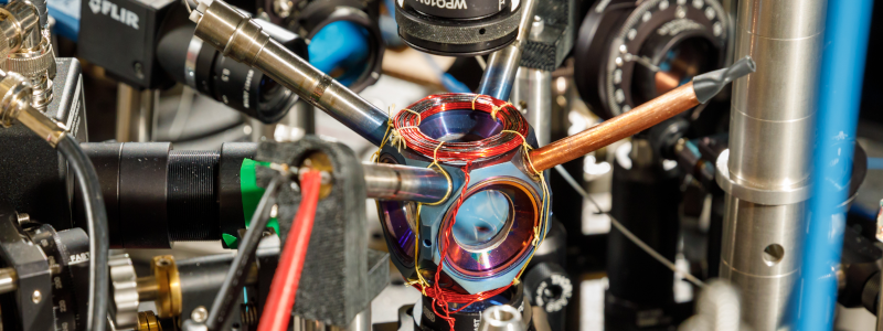
The people at Sandia National Labs worry about things like that and they want to replace GPS with quantum accelerometers and gyroscopes. The problem: those things take expensive and bulky vacuum systems and lasers. Sandia, however, has had a sealed device about the size of an avocado that weighs about a pound that could possibly do the job. Their goal is to see it work without maintenance for four more years.
This is no ordinary vacuum tube, though. It is made of titanium and sapphire. By itself, the device doesn’t do much of anything, but it shows that rubidium can be contained in a sealed chamber with no additional pumping. These quantum sensors aren’t anything new, but a tiny self-contained cold-atom sensor can pave the way for putting these sensors in vehicles like ships, aircraft, and ground vehicles. Submarines, which don’t usually have a clear shot at the sky without floating an antenna, are also candidates for the new technology.
A navigation system based on this technology uses a laser to cool the subject atoms and then measures their movements. This allows very precise determination of acceleration and rotation which allows for a more precise inertial navigation system.
If you need a refresher on how GPS works, we can explain it. If you think the idea of a module containing rubidium is far-fetched, don’t forget you can already get them for precision clock work.


Could it work for spelunking?
Inertial nav can be used for anything that requires a location fix. It’s only issue is that successive movements introduce a rounding error that compounds so periodic position updates are required . Basically it knows where it was and where it went to for how long and which way.
Just don’t bump it too hard (non-linear/saturation), or move it too slowly (sensitivity limits).
Low drift is just one point on the list of desirable features.
Integrate a small *residual* error no matter how small long enough, it’ll become significant. That’s a known problem with integrators. Think of these type of errors as things like DC offset and it accumulates every time you update your new position.
Caving for 4 years? No vitamin D for you…
Have a feeling the associated kit might be a little on the heavy side and perhaps a bit bulky after all the water and shock proofing. But yes, stable inertial reference points would be great for mapping what lurks beneath.
The point is to have the device work at all for at least five years. It would be annoying to find that the vacuum has leaked while sitting in storage – which it will at some point.
But think about how much time you’ll have with Bat Boy!
listened to a C++ podcast where the guests worked for a company that sends flying drones into mining shafts (caves) to map them out in detail – I suppose it starts from a known reference point and determines mapping coordinates based on accelerometers and gyroscopes as it moves about. So seems likely this device could work for spelunking navigation
Most likely they also use ‘Simultaneous Localization and Mapping’ (SLAM) in addition, potentially with post processing and loop closure. Have a look at it if you are interrested :)
Seems like a whole lot of words to avoid the term IMU. (inertial measurement unit)
Or “dead reckoning”, for that matter. Dead reckoning has a bad rep, and for good reason – it doesn’t replace GPS. It’s mostly only useful as a compliment to other forms of navigation, so you can estimate your position until you can get a proper fix again. Even the most accurate systems will accumulate error over time.
In the words of that one air force training video – the missile knows where it is because it knows where it isn’t. An IMU thinks it knows where it is because it knows where it was, but it really doesn’t know where it is because it isn’t where it thinks it is.
My wife often has a go at “dead reckoning”. Not mocking women in general or anything. Just this particular one. I wait till she’s finished, then the daughter and I have a secrete bet that it’s the other way. So far we’re winning.
On the bright side, it helps get a few extra steps in while out for a walk.
That works until your daughter grows up and become yet another problem… But then again she has her own group to hang out with.
My daughter has had a terrible time driving to various locations around Rochester (pop. 106,000).
I think it was because for the 4 years previous she had her eyes glued to a cell phone instead of looking out the car window.
The term might be more usefully called Ded Reckoning as in deduced.
Most transport aircraft use the INS as the primary location fix, and the GPS as the secondary.
Depending on energy requirements, this may or may not work in portable applications.
Normal mode of navigation on a wide body Airbus is ‘GPS PRIMARY’. If there is a failure of the GPS system the inertial is good enough to get you across the pond but not good enough to fly certain non-radio based approaches that require high accuracy. Inertial units are primary for attitude reference, though.
Prior to GPS, removing the INS drift error would happen when the aircraft got within range of ground based stations that could be used to fix it’s position. It was not uncommon to be 10 – 15 miles off after a crossing, so traffic separation requirements were quite high.
GPS is required today on non-radar routes with the closest aircraft spacing.
This doesn’t really replace GPS, necause there is a fundamental limit to the performance of any IMU that is independent of the measurement noise and accuracy of the IMU itself. And that is the accuracy with which the local gravitational field vector is known. Because any IMU has to subtract the gravity vector before it can integrate acceleration to obtain position, any uncertainty in local gravity still quickly causes even the best quantum IMU to drift away.
But on the bright side now we can measure gravity more accurately and over time we can plot the movement of earth geology. e.g. magma,plates,etc.
What isn’t clear to me is how this is superior to a 5$ IMU from spark fun.
Just guessing, they’re going to claim better accuracy or lower drift or both. But the complete lack of details in the original article doesn’t inspire confidence.
“Vacuum “Tube” Might Replace GPS One Day”
(clicking through to the fine article…) … Is an awful lot of breathless extrapolation from an article that just demonstrates they have come up with a way to maintain a pretty good vacuum (nanotorr) in a golf-ball-size package for a few months.
But the
corporategovernment national security laboratory media drones do what they gotta do to put food on the table, I guess.In larger vehicles you could have more than once and space them as far as possible from each other within the vehicle. You then use that redundancy and the fact that they know their location relative to each other to reduce some of the sources of error.
I know people who write press releases like to make overblown claims to gain attention, but the Hackaday audience is composed mostly of geeks. We’re predisposed to argue about details like “what’s the difference between GPS and an IMU?”
IMUs make it possible to estimate position and orientation relative to a known reference point. GPS is a collection of reference points relative to the surface of the Earth whose positions are are tightly calibrated and continuously maintained. Saying an IMU can replace GPS is like saying it could replace the international prototype meter bar.
And speaking of superseded technologies, let’s see how the IMU’s estimates or relative position stack up relative to a 19th-century surveyor’s chain and transit over a few hundred miles before taking on GPS.
Looks like the precursor of the flux capacitor to me.
This could help autonomous vehicles resist spoofing attacks, which will be vital for anybody remotely important.
There are several companies out there working on chip sized surface mount inertial trackers that they claim are “navigation grade”. Mostly for the drone/UAS market. I’ve even seen some that combine inertial tracking and multi-GNSS receivers into the same chip.
Is this a case of a better mouse trap, or something else entirely? I mean millimeter vs half meter accuracy is great but what are the applications outside of precision STEM projects? More importantly will quantum sensor avocados be affordable or durable enough for commercial use?