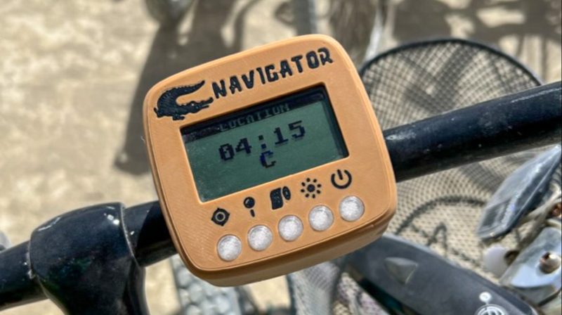
When setting up a city in the desert, the team behind Burning Man does its best to lay things out in an ordered fashion. Even still, getting around at ground level can be a challenge at times, and it’s easy to get lost. To help get around easier, [Zach] developed a nifty GPS device built specifically for navigating the ephemeral clock-like city.
The device is built for a few simple purposes. It shows where you are, it helps you navigate somewhere you’ve been before, and it helps you navigate to portable toilets. It’s set up to be usable both on bike and on foot, the typical ways of getting around the playa. Since Black Rock City is fairly simple, it uses an arrow to point to a desired waypoint, and is capable of storing up to five points of interest. It’s built using a cheap GNSS receiver and transflective LCD screen, and a Pi Pico is the brains of the operation.
The value of the device is obvious, particularly when exploring deeper areas of the playa, or after the road signs have been removed or structures have been taken down or burnt to ashes. We’ve seen some other great projects from the desert festival before, too. If you’ve got your own playa-spec hacks, don’t hesitate to let us know!


Is it mud proof?
“The weather for the 2023 burn was wild, with several heavy rain storms. It continued to function after being out in the rain for hours. “
Merge to a meshtastic fork!
It (they) were built to a $20 price point.
They could then be sold for $250 each to the millionaires that infest BM.
Wow you beat me to it! I was planning to create a near identical project this year even down to the name “Playa Navigator”. Ahh yes in true BM fashion any time you think you’ve come up with a unique idea it turns out someone already did it years ago. 😁
I LOVE the portos button. Perfection.
I built playa navigators at least since 2016. Inexpensive (an Arduino, a 4 line LCD display, a GPS chip w/antenna), and would display your position in Black Rock City “clock radii” (angle…) and “how many feet to the Man”.
If you were in the camp portion of BRC, it could tell you what city street you were on, or which pair of streets you were between. Also speed (valuable for keeping to that 5mph rule), and time.
East to implement a map display.