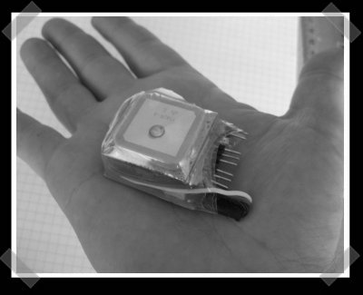
This is a nice, compact gps logger that’s built around a PIC16F872 and some eeprom chips. It was designed for a particular GPS receiver, but should be easily adaptable to others since the unit ouputs standard sentences at 4800 baud. Full schematics and board layout are available on the project page.
gps hacks208 Articles
Dash Express Now Twittering
Here’s a quick hack to satiate our appetite for location aware applications. The Dash Express is a GPS unit with cellular and WiFi radios so it can do two way communication. Out of the box it can download maps and traffic on the fly. A little while ago they opened up the API so the device could receive info from other web services and owners could give feedback, like reporting speed traps live. The handy hack embedded above publishes your location to Twitter; we would have preferred it hit an actual location service like Brightkite. This just the tip of the iceberg when it comes to possible applications. We wonder what the adoption rate of the Dash Express will be, since the iPhone also has a touchscreen, GPS, and of course a cellular connection.
We’ve got a Dash Express in the lab and it’s based on the OpenMoko design. What sort of tomfoolery would you like to see us do with it? What do you think the killer app for the Dash Express will be?
[via Gizmodo]
Location Aware Task Tracking
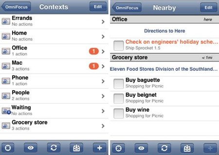
With the iPhone finally getting legitimate GPS we’re bound to see more widespread use of location based apps. Services like Dodgeball, Brightkite, and a few Twitter clients have been around, but failed to tightly integrate with the hosting phone. Now we’re seeing applications that reach beyond just “finding your friends”. [Merlin Mann] directed us to the version of OmniFocus for the iPhone. OmniFocus is a task management system that’s now location aware thanks to the iPhone. This means it knows to show you your grocery list while you’re at the store and work tasks while you’re at work. Passive interaction could really make similar systems a lot more enjoyable to use.
We think this is just the tip of the iceberg. Imagine alternate reality gaming that gives you a virtual map while you navigate the real world. Geocaching, road rallies, and scavenger hunts could have a running narrative displayed as you progressed. Using technologies like GeoRSS will let us pull data back into the real world making that rare trip outside a lot less painful.
DIY TomTom Docking Station
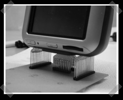
TomToms have been getting pretty cheap. We like ’em because they’re nice and hackable. This diy docking station was made from some etched PCBs, a bunch of male pin headers and a bit of hot glue.
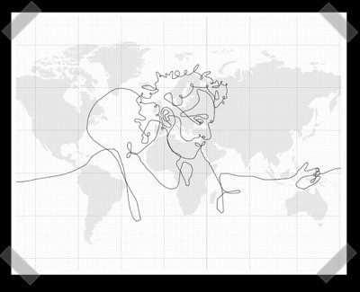
Biggest Drawing In The World Created With GPS
UPDATE: The text: “This is fictional work. DHL did not transport the GPS at any time” has been added to the bottom of the page since the original posting.
Artist [Erik Nordenankar] has created the Biggest Drawing In The World. At least that’s what his URL says. He used the movement of a GPS device to create a giant single line self portrait on the globe. His Pelican case containing four large batteries and the GPS data logger was handed off DHL with very specific travel instructions for its 55 day journey. It’s a pretty amazing feat, but we really wish the case had managed to make the trip without the close watch shown in the video.
Continue reading “Biggest Drawing In The World Created With GPS”
Autonomous Catamaran
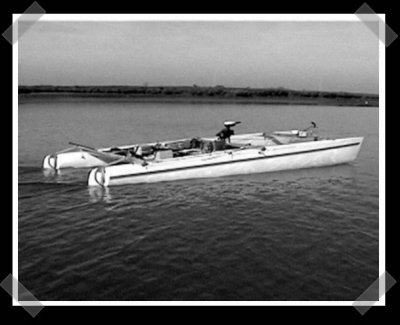
[Gabriel] put together an impressive writeup of his autonomous catamaran, Atlantis(PDF). It was certainly done as an academic project, but there’s a thorough explanation of the math logic behind the control systems. The heart of the boat was a waterproofed Pentium laptop with a CAN bus parallel interface used to talk to everything on-board. Sensors included GPS, wind, hull speed and rudder angle. In case the site can’t handle the load, I’ve mirrored the 1.4MB PDF here.
Underwater GPS (sorta)
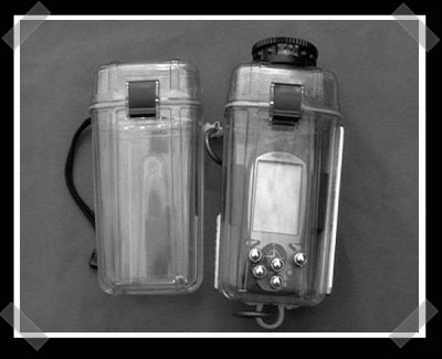
Since water blocks the radio frequency used for GPS triangulation, GPS is considered pretty useless for SCUBA divers. Apparenlty some of them are finding it useful to waterproof off the shelf units for tracking the beginning and end of dives. (Dives in open water often involve currents that can really move you along.) To avoid any wiring, a floating case is used. When the diver wants to grab a waypoint, he/she lets the gps surface for a short while to acquire a fix. Then the diver can pull it back down and mark the waypoint or record the coordinates.