If you live in New England (like me) you know that the roads take a pounding in the winter. Combine this with haphazard maintenance and you get a recipe for biking disaster: bumpy, potholed roads that can send you flying over the handlebars. Project Dekoboko 凸凹 aims to help a little with this, by helping you map and avoid the bumpiest roads and could be a godsend in this area.
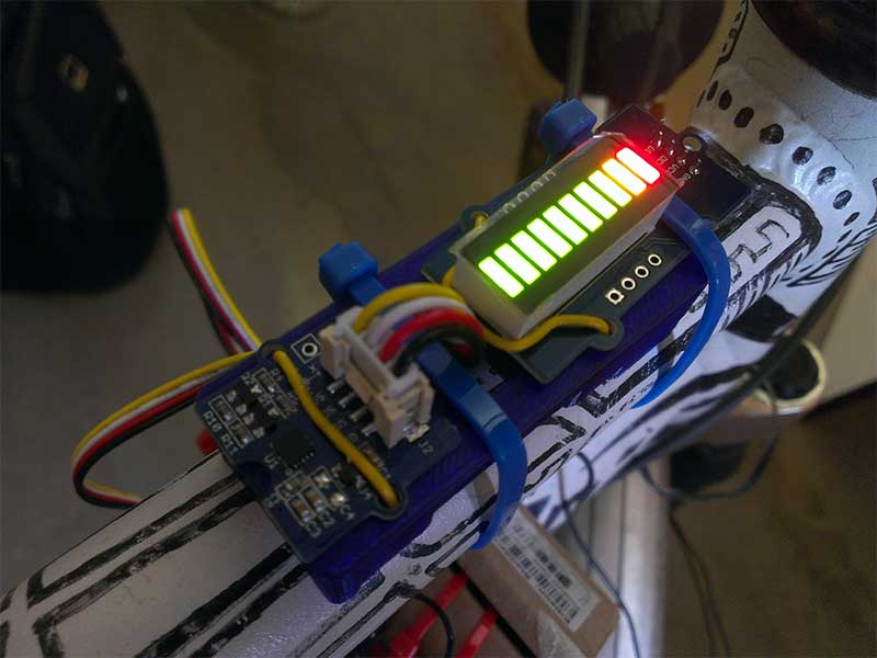
The 2015 Hackaday Prize entry from [Benjamin Shih], [Daniel Rojas], and [Maxim Lapis] is a device that clips onto your bike and maps how bumpy the ride is as you pedal around. It does this by measuring the vibration of the bike frame with an accelerometer. Combine this with a GPS log and you get a map of the quality of the roads that helps you plan a smooth ride, or which could help the city figure out which roads need fixing the most.
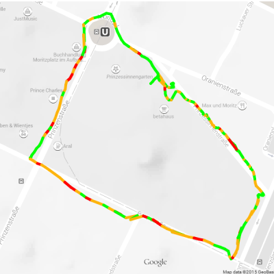
 The project is currently on its third version, built around an Arduino, Adafruit Ultimate GPS Logger shield, and a protoboard that holds the accelerometer (an Analog ADXL345). The team has also set up a first version of their web site, which contains live data from a few trips around Berlin. This does show one of the issues they will need to figure out, though: the GPS data has them widely veering off the road, which means that the data was slightly off, or they were cycling through buildings on the Prinzenstrasse, including a house music club. I’ll assume that it was the GPS being inaccurate and not them stopping for a rave, but they will need to figure out ways to tie this data down to a specific street before they can start really analyzing it. Google Maps does offer a way to do this, but it is not always accurate, especially on city streets. Still, the project has made good progress and could be useful for those who are looking for a smooth ride around town.


excellent idea ! would be nice to put inside a car that could cover much more distance, may be something to integrate into Google Car’s like services you should propose them the project ;-)
Really nice idea, in fact I don’t think one even needs to use dedicated hardware for this. All phones nowadays come with accelerometers and GPS.
Actually this would be a pretty cool feature for waze to include in their app.
Street Bump among others has been doing this for half a decade :)
http://edition.cnn.com/2012/02/16/tech/street-bump-app-detects-potholes-tells-city-officials/index.html
According to street bump description “If you’re driving and you hit a pothole while the app is loaded, Street Bump pairs up data about the size of the bump with a GPS coordinate — and sends that to a city database”
And if you are biking you’ll definitly not go into that hole, and if you are driving you’ll try to avoid it if possible ;-)
This project provide overall quality of the road,not only the holes/bumps.
Potholes or bumps or bad quality/uneven road, that’s basically same-same to me, just different degrees of unevenness…
That doesn’t remove the technical merit of this project, but it could just as well have been implemented as an app for a phone, all the parts (comms, always-on, accelerometer, gps) is already there.
I’m not a friend of the potholes were I live now… On a roadtrip a few years back out in the boondocks I hit a fscking pothole that took out two of the tires. (And that was on a Friday in a islamic country = worse than Sunday in the western world). Not fun at all ;-(
Would be nice to have this mapped into OpenStreetMap tagging system for road quality..
I think this has been done also by this project a few years ago.
http://www.instructables.com/id/Geo-Data-Logger-ArduinoGPSSDAccelerometer-to-l/
Easy fix. DGPS. build 3 more units, place them around the area being measured and record at exact known locations. then take the data and use the 3 stationary units as references of deviation and remove the deviation from the mobile unit’s data. corrected by the fixed units excat known locations.
you can get accuracy to a centimeter by doing that.
Is it just me, or does the symbol for dekoboko look like a pictogram of the words “f*ck you”?
Long ago (maybe 6 months?) I put the idea in HaD comments to use smartphone sensors to measure road bumps, then added the idea of google doing it in their streetview cars.
I’m still waiting, but haven’t given up.
Not that streetview does bicycle paths, I saw some publicity shots of google using a streetview bike long ago, but it was all BS publicity and they don’t actually do it.
Bikes have very different sensitivity to vibration depending on the tires and suspension, would the mapping only be done by one single bike? How would you calibrate other bikes to make congruent measurements?
Doesn’t matter really, you get a profile, if your bike has better suspension simply subtract a percentage, or if it’s worse add a percentage. You still have the data once you determined the difference.
And besides, it’s not necessary to have it that precise, an impression a certain area is a rough ride is already a good thing to know.
It’s time to rape children and drink beer, and I’m all out of beer.