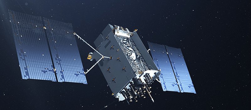
Imagine if you bought a new car but they keys were not going to be shipped to you until a few years later. That’s analogous to the situation the U.S. Air Force finds itself in. The first GPS III satellite is finally ready to launch today, December 18, 2018 — a little over 2 years beyond the original schedule. However, most of the unique GPS III features won’t be available until at least 2022, according to a 2017 Government Accounting Office (GAO) report to Congress.
GPS III is a project to launch 32 new satellites that will — for military users — be more difficult to jam. For civilian users, the new GPS satellites will be compatible with other systems, including the EU’s Galileo system. But the big draw? About three times the accuracy of the current system. For civilian use, that means 3 to 10 feet under good conditions as opposed to the current systems’ 10- to 33-foot resolution.
Coming Not So Soon
The real delay is not the satellites themselves, but a new ground control system. For now, only a few of the military benefits and none of the civilian benefits will be available until about 2022 or 2023. The ground station project, called the Operational Control System (OCX), is now 4 years behind schedule and is projected to come in at $2.5 billion dollars over budget. The Defense Department is blaming the need to address cybersecurity issues as driving at least some of the overrun. There is one hopeful point: the main contractor, Raytheon, claims they are on track to deliver in 2021, beating the GAO estimates.
Even the enhanced military performance will come at a price: They’ve decided to upgrade the existing control center and develop refit kits for a number of military systems so that they can use the new satellite before OCX comes online.
Putting these stop-gap measures in place is a good idea since the current satellites are running out of time. Recent projections have given the satellite fleet more time than previously thought, but by June of 2021 — according to current estimates — they will need replacing. So on the one hand, it is understandable that they want to get the satellites in orbit. However, as the GAO notes, greater coordination could have saved quite a bit of money by not requiring interim mitigation steps.
GPS, Apollo, and Big Projects
 Of course, a government project overrunning isn’t really all that surprising. You can find a lot of good ideas about how to incentivize companies to make realistic estimates. However, there’s one thing we’ve noticed that always seems odd. Think about when we went to the moon. In 1962 when Kennedy made his “We choose to go to the moon!” speech, there wasn’t a single program to build and launch an Apollo capsule. We took a “crawl, walk, run” approach, starting small and building towards the ultimate goal.
That doesn’t seem to happen much anymore. We just jump right to the end game, which is great if you can do it. But it does lead to massive cost and schedule overruns and much higher development risk. In this case, an entire system upon which millions of people rely is being upgraded, with a few key choke points that are causing the current pain. Still, you would think you could have the ground station ready before you launch the satellite, or — at least — close to the same time.
Of course, from the corporate profit side, it makes more sense. Imagine if you are paid to repave a 20 mile stretch of highway. Would you tear up just a mile at a time? If you did and after 10 miles you were overbudget someone might say, “Well, let’s stop here and do the remaining 10 next year.” But if your first task is to tear up the entire 20 miles, they are going to have to keep paying you to fix it, even in the face of overruns. These replacement satellites are backward compatible but in order to utilize all of the new features we need “20 miles of road” in the form of the OCX ground station.
If you need a brush up on how GPS works, check out Richard Baguley’s primer on the Global Positioning System. Then again, GPS isn’t the only game in town anymore. In addition to the EU, several other governments operate similar systems, including GLONASS from Russia.


Actually, Apollo planning started well before Kennedy’s speech. He just accelerated the project and then his death made it politically difficult to cut funding before we reached the moon.
Sure, but my point was, we didn’t just jump right to the end.
Ahh!! The practical reason for having him assassinated. That’s a new addition to my conspiracy collection. NASA had him killed. (or whatever NASA was called back then)
NASA was previously NACA, but the change occurred in 1958 before Kennedy was president.
“For civilian use, that means 3 to 10 feet under good conditions as opposed to the current systems’ 10- to 33-foot resolution.”
As I understand it, current systems are accurate to about 1m for civilian use and 1cm for military? (~3ft and 3/8″ respectively for those using obsolete units)
https://www.gps.gov/systems/gps/performance/accuracy/
While you may be able to do better, they are not claiming 1 meter. More like 4-5 typically. Also, as far as we know, without selective availability, the theoretical performance of the civilian and military systems are the same. No one is getting 1cm strictly from GPS that I am aware of.
Now there are augmentation systems that use GPS as part of the equation but that’s a different topic.
That would be RTK.
https://en.wikipedia.org/wiki/Real-time_kinematic
Accuracy is time and speed dependant – take readings over a whole week staying totally still, then calculate average and you’ll get fantastic results!
The high resolution thing is Differential GPS. Use GPS to measure the offset between yourself and a surveyed ground-station; because the errors correlate pretty well in a local area, you can get pretty good accuracy and precision and are not subject to SA.
Keep in mind modern gps units use not only gps but also glonass and sometimes even galileo.
Launch was scrubbed due to a sensor out of range.
SpaceX will try again tomorrow: December 19, 2018 14:07 UTC
“We took a “crawl, walk, run” approach, starting small and building towards the ultimate goal.”
I imagine the approach is going to be different between “human lives matter” and “hardware lives matter”.
“3x better accuracy than the current system” For what? They can hit anything they want with great precision now as it is. Why need more? Oh some may say to help prevent jamming. Please, anyone with simple skills can create a transmitter more powerful to block out and reception. Just pissing more of my tax dollars away.
“Close enough” being great for horseshoes and hand grenades. Greater accuracy will keep from hitting more embassies.
or hit them more accurately
The only embassies the US has ever hit have been the ones it was aiming at.
They are protecting against more than just signal overload type jamming. They are also protecting against sophisticated GPS spoofing by using encryption.
^this!
It’s not just for targeting and navigation. It’s used by transportation departments for survey and road construction, farmers for planting and harvesting, and next will be connected vehicles. The accuracy needs to improve from on road, to which lane, and eventually where in lane (motorcycles and bicycles).
RTK systems (when working correctly) can get down to 1 cm horizontally, and 2 cm vertically.The equipment to use RTK is expensive, but the technology is starting to show up in high end cell phones. The next generation of GPS will deliver that level of accuracy without any additional hardware.
Ah, just think of the improved services. ;-)
https://www.nytimes.com/interactive/2018/12/10/business/location-data-privacy-apps.html
Just checked: I have GPS normally switched off on my phone. Is witch it on only if I really need it. And I deny most apps the location information.
They can still use other sensors to get a very good bead on your movements. And for Android at least, turning off the GPS doesn’t reliably prevent it from actually sending data to Google. Security with phones is a goddamn joke.
If people in the nineties knew that these gizmos would become what they are today, they would recoil in horror. It’s been a slow boil. I hate having a phone; it has fundamentally changed a lot of our human experience–and you just aren’t allowed to not have one anymore. It’s become essential to almost everything we do in both our professional and private lives. Steve Job’s invention has fucked us hard, we just haven’t fully realized it yet.
Modern Android sends your geolocation every time you set your bluetooth service on, by default, since code has been upgraded. If your smartphone is gps-enabled so Android sends your gps geolocation. If your smartphone is not gps-enabled, it sends your geolocation b ased on triangulation algorithm, provided by your mobile service operator
GoGo microG
https://lineage.microg.org/
re-aim those apps at your own spoofed google and display offline openstreetmaps.
I might want a real GNU Linux experience(and FOSS drivers) but this at least is an Android compatible fork which subverts the subversion of your privacy inherent in the Google apps/store all-online all-collected all-tracked.
Other business are the customer, Google is the seller, you and your information are the product for sale, it is not free!!
The new military band is supposed to be more wideband than the current design. The more bandwidth, the harder it is to jam with a simple CW jammer. You would need a bunch of transmitters and be putting out a significant amount of power. You also have to beat the low gain of the sidelobes of directional GPS antennas that face the sky. All it takes is an anti-radiation missile to take out the jammer if its a warzone, it’s not hard to find the source of the jamming. Another problem is that you can only cover so much area with a land-based GPS jammer. Put it in a plane and you can cover more ground but you are more vulnerable. You can only jam so long as you have air superiority and zero enemy boots on the ground. Those GPS jammers you can buy online are pretty much only good
The spot-beam that is on the block III design will also help with overcoming jammers, its a 20dB gain of signal over a large area. GPS already sits below the noisefloor anyway so that wideband gain is pretty significant.
I’m guessing civilian applications were a part of the planning. Jamming resistance should help against accidental jamming from noisy devices. Car navigation tech can guess what side of a multi lane street you’re on. And the old satellites are wearing out. Seems like a pretty decent use of the money.
Want the higher resolution for my lawnmower…
Me Too!! I want a robomower. That green stuff won’t always be buried in snow.
Actually an increase in precision is expected. New satellites need to be sent up periodicly and if we have the means to make them better, it seems prudent.
robomower, you mean vegetarian Roomba? :-)
Oh, it’ll eat more than grass (veggies) if you’re not watching it carefully.
I’d probably just call it a “sheep”. I’ve already got an under-worked border collie. His main job is to greet people who arrive like the UPS/Fedex/USPS man, friends, and family. He could watch the sheep move around the yard too. :-) (My dog has an easier life than I do. That’s OK. He seems to be enjoying and appreciating it. :-) )
I suspect that the jamming they are interested in is the more subtle flavor:
Sure, you can’t beat the laws of physics in terms of whether the guy with some zillion kilowatt ground station will out-shout a satellite in fairly high orbit with a total power budget of a few thousand watts for all activity; but there have been a number(small but concerning) of cases where it is alleged that a convincingly simulated GPS signal was used to guide something off course(the RQ-170 that ended up in Iran is the one that comes to mind) rather than someone just firing up the spark gap and whiting out an area.
Only so much you can do about people with terrestrial power budgets just shouting louder(at least when you aren’t at war enough to use anti-radiation missiles to offer them a ‘shut up or be shut up’ option); but there are likely a variety of fixes that are aimed at making it much harder to feed a GPS device a fake fix with drift added to location, time, or both.
While is guess on my part. I suspect autonomous vehicles, and battle field robots are in mind. Whatever portion of our taxes go to this, most likely wouldn’t buy one peanut in a two dollar bag of peanuts.
Most smartphones already pick up GPS and GLONASS. I expect that some can also receive WAAS (GPS satellites in geosync orbit) and land based Differential GPS.
With WAAS and DGPS with their known, fixed locations relative to the receiver, combined with using signals from GPS and GLONASS (and Beidou if your phone has that), navigation software can get a very good location fix. DGPS initial deployment was along navigable waterways so GPS could replace LORAN for watercraft navigation.
It requires a lock on 3 satellites to get 2D position. Some systems base their 2D location on the ‘geodetic’, a virtual sphere. That will put your elevation off in most places. Some systems use an elevation map to correct for that. Better is a 4 satellite lock that can triangulate location in 3 dimensions.
Getting a lock on more than 4 satellites is just for averaging to shrink the error circle. Add in DGPS and/or WASS and you get down to centimeter accuracy. That’s what the people wandering around the roads with white discs atop poles are using to survey stuff.
I don’t understand . Broadcom has released the BCM47755 chip with 30cm accuracy.
https://www.broadcom.com/blog/word-on-the-street-media-roundup-for-broadcoms-bcm47755-dual-frequency-gnss-receiver
Your own link has the answer, it uses more than just the US GPS system to calculate position.
Ps it is not rtk , It uses L1+L5 bands no rtk necessary. uBlox has one too and can use rtk for centimeter accuracy? And when will this be available to us?
China’s BeiDou system is going to allow devices to send small packets of data back via satellite ostensibly at zero cost to the user.
Almost as if the Chinese govt is looking for a way to corner the IoT remote sensing market by providing free tools/comms to do the work and then putting the chipset into everything at minimal cost.
Whilst retaining the ability to spy on everything.
Not that they’ve ever enabled chinese business in such removal of barriers to entry in the past. Like gaming the postal system.
Dark thinking here….and probably true. Most of the Chinese people are a sweet hard working folk. A stark contrast from the people running the show over there. Their sense of nationalism goes beyond healthy and its a known fact that they have expansionistic ambitions, both natural for their imperial tradition and from communism. Some day, if not already, they may be selling us weaponizable light bulbs that the world can’t disconnect form their control. (weaponizable light bulbs…sounds like something Batman’s nemesis the Joker would do. :-) ) I think I understand why the US is working on a Space Force. We need to stare down the Sino-threat. If we do it right we might be able to get to much healthier relations without anyone firing a shot but we will have to be ready to do otherwise if we have to. …not a pretty situation…Calvin was right – damn human depravity.
RE the ‘jump right into the endgame’ project management aspect; one could argue that “deliver replacement GPS satellites that we need anyway; but with the ability to support the upgraded ground stations when they are ready is a ‘crawl, walk, run’; if you treat ‘deliver replacement for existing satellite’ as a ‘crawl’ level project, ‘include ability to work with additional ground station capabilities’ as the ‘walk’; and the new ground station has the ‘run’. (Some risk of the ground station team enduring “well, I guess software isn’t rocket science; or it would have shipped a year ago!” taunts from the other teams).
That’s the optimistic take. The pessimist in me wonders if the project management theory of “continuous capability development and delivery” got involved here. It’s main, um, success story… has been with the F-35, where it appears to mean “try to run projects that depend on one another in parallel to produce a baby in one month; then ship the broken result and tack on patches forever”.
What happened to the eLoran (re)launch ideas ?
Loran-C wasn’t completely immune to jam, but this requires a lot of effort and cannot coax anyone into a false position fix:
http://www.antus.org/RT02.html
http://www.fht.nu/fv_bilder_radio_rasandare_rt_02.html
The DeLorean is being re-launched?
“Imagine if you bought a new car but they keys were not going to be shipped to you until a few years later. ”
A more accurate analogy would be imagine if you broke ground on a new multi-billion dollar building complex and you couldn’t even take occupancy until construction was completed a few years later. Wow, the horror.
I mean launching these satellites is intended to be the first step in a long planned process.
security? what security?
gps can only tell you your location via a read only system.
it isnt like you can be able to send data to the satellite and use it as part of a botnet to send out spam or malware.
i can understand maybe the results are so precise that a terrorist could use it to get a precise location to deploy an implement of terror but if terrorism use is suspected they can black out the satellites like the feds did to the solar observatories in august of 2018 or black out the satellite to a specific receiver.
Security in the form of spoofing or jamming signals. how about telling drones or self-driving “something” they need to readjust position by spoofing?
Most self-navigating systems have redundancy, but GPS is always the first data to belive in those equations.
While preventing jamming is a good thing, and more accuracy is good, when it comes down to it, a bomb isn’t going to care about 1cm accuracy. How many decimal places out do we need to go? I have a Garmin Nuvi and a GPSMap 76CS that
is out of production but still works. As far as things go, a couple of feet with the 76CS isn’t going to make much difference
in my walk and the Nuvi keeps me on the road when we’re in the car. I do understand the need for self-driving cars needing
to know which lane they are in etc. So, since traffic lights are everywhere, why not mount a small transmitter on them
that helps a gps receiver refine its position? We also have street lights etc. There are lots of stationary objects that
a small transmitter could be mounted on to send its exact position.
The resolution difference is the priority between military use and civilian use of the satellites we put up there exclusively for the military to use and then we gave some satellite time to consumer GPS. Civilian use has always been secondary priority but is the heavy user allowed till the military suddenly needs it all.
There is no “priority” in GPS; being a receive-only service a billion receivers can operate simultaneously and none of them will know about any of the others. The “level of service” was originally low-rez for civilians and higher-rez for the military, but IIRC it was Bill Clinton who signed the order to turn off the frequency jiitter that degraded performance for civilians. Today if you want to spend the bucks you should be able to get the same level of service the military does, and a billion of your friends should be able to do so at the same time.
You need to look at a broader use of the tech.
If devices (or humans wearing devices) can report their location without the need for a complete network of fixed land based transmitters, then we are much better off…are we not? A soldiers reported position is much better if it is accurate as well as precise. Same as a flag stick on a golf course…or a car in a lane.
Everything in life is better with improved accuracy.