Keeping track of position is crucial in a lot of situations. On Earth, it’s usually relatively straight-forward, with systems having been developed over the centuries that would allow one to get at least a rough fix on one’s position on this planet. But for a satellite out in space, however, it’s harder. How do they keep their communications dishes pointed towards Earth?
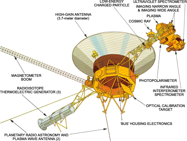
The stars are an obvious orientation point. The Attitude and Articulation Control Subsystem (AACS) on the Voyager 1 and 2 space probes has the non-enviable task of keeping the spacecraft’s communication dish aligned precisely with a communications dish back on Earth, which from deep space is an incomprehensibly tiny target.
Back on Earth, the star tracker concept has become quite popular among photographers who try to image the night skies. Even in your living room, VR systems also rely on knowing the position of the user’s body and any peripherals in space. In this article we’ll take a look at the history and current applications of this type of position tracking.
Celestial Navigation

Celestial navigation has been practiced for thousands of years. In theory, all you need is your eyes and some knowledge of how the Sun, Moon and stars move in the skies throughout the seasons to get a sense of direction. But this doesn’t tell you your position on the Earth’s surface.
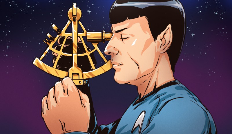
For most of human history, ships would stay within sight of the coast and rarely cross large bodies of water. When they did crossings, they would often use dead reckoning, using one’s known position, heading and speed. Although the concept of latitude had been around for a while, measuring latitude accurately required angle-finding instruments, such as an astrolabe, invented around 200 BC, or a sextant, invented in the 16th century.
An astrolabe, sextant, or similar measures the angles between known celestial bodies, from which the latitude can be deduced. The determining of longitude was a major question that ultimately came down to having an accurate clock, as longitude and solar time are directly related. The invention of timepieces that were both accurate and could be used on a ship or moving vehicle would not be solved until the 19th century when they became reliable and affordable enough that alternatives (lunar distance method) fell out of favor.
Finding one’s way in space
Although navigating in the mindbogglingly massive vacuum of space may seem harder than navigating on Earth, essentially the same principles apply. The most important thing is to have at least one point of reference. In the case of Earth-based navigation, this can be the Sun, the Moon or any bright star with a known trajectory and location in the sky.
For a space probe, the common metaphor of ‘sailing the ocean of stars’ is rather apt when it comes to navigation. The Attitude and Articulation Control Subsystem (AACS) as it is known on the Voyager, Cassini, and other spacecraft form the core of the navigation and positioning system. In the case of Cassini, it uses a number of sensors, including Stellar Reference Units (SRU), Inertial Reference Units (IRU) and Sun sensors (SSA). These SRUs are CCD-based star trackers that together with the other units keep the spacecraft aware of its relative position in space.
The Voyager spacecraft use a similar AACS system, as did other spacecraft in the past and probes after Voyager 1 and Voyager 2. For attitude reference, star trackers, star scanners, solar trackers, sun sensors, and planetary limb trackers are used. Voyager’s AACS uses a sun sensor for yaw and pitch reference, and a star tracker to continuously track a bright star at right angles for roll reference. Galileo references a star scanner that rotates with the spinning part of the spacecraft. Magellan used a star scanner to obtain a fix on two bright stars during a special maneuver every few orbits.
It isn’t just in space where star trackers are useful, either. In order to take photographs of the Milky Way and the night sky, the film or camera sensor requires long exposure times in order to gather sufficient light from the (faint) star light. Because the Earth rotates continuously, the position of the stars is shifting, and this makes a blurred mess over even a ten second exposure time, let alone half a minute or longer. In the old days, rotating the camera or telescope along with the stars was done by aligning a pivot with the earth’s axis and turning it at a preset rotation speed for one’s location on Earth. More modern astrophotography rigs use a photo sensor that keeps a fix on one or more stars, moving the camera that is mounted on top of the tracker with just the right amount to get a sharp image.
Bodies in Space
For the moment at least, the Final Frontier when it comes to tracking one’s position is not outer space, but our living rooms. Significant R&D money is being invested in creating an ever more realistic and natural Virtual Reality (VR) experience. This requires that the system can keep track of not only where the user is looking in the virtual world, but also where their appendages are currently located.
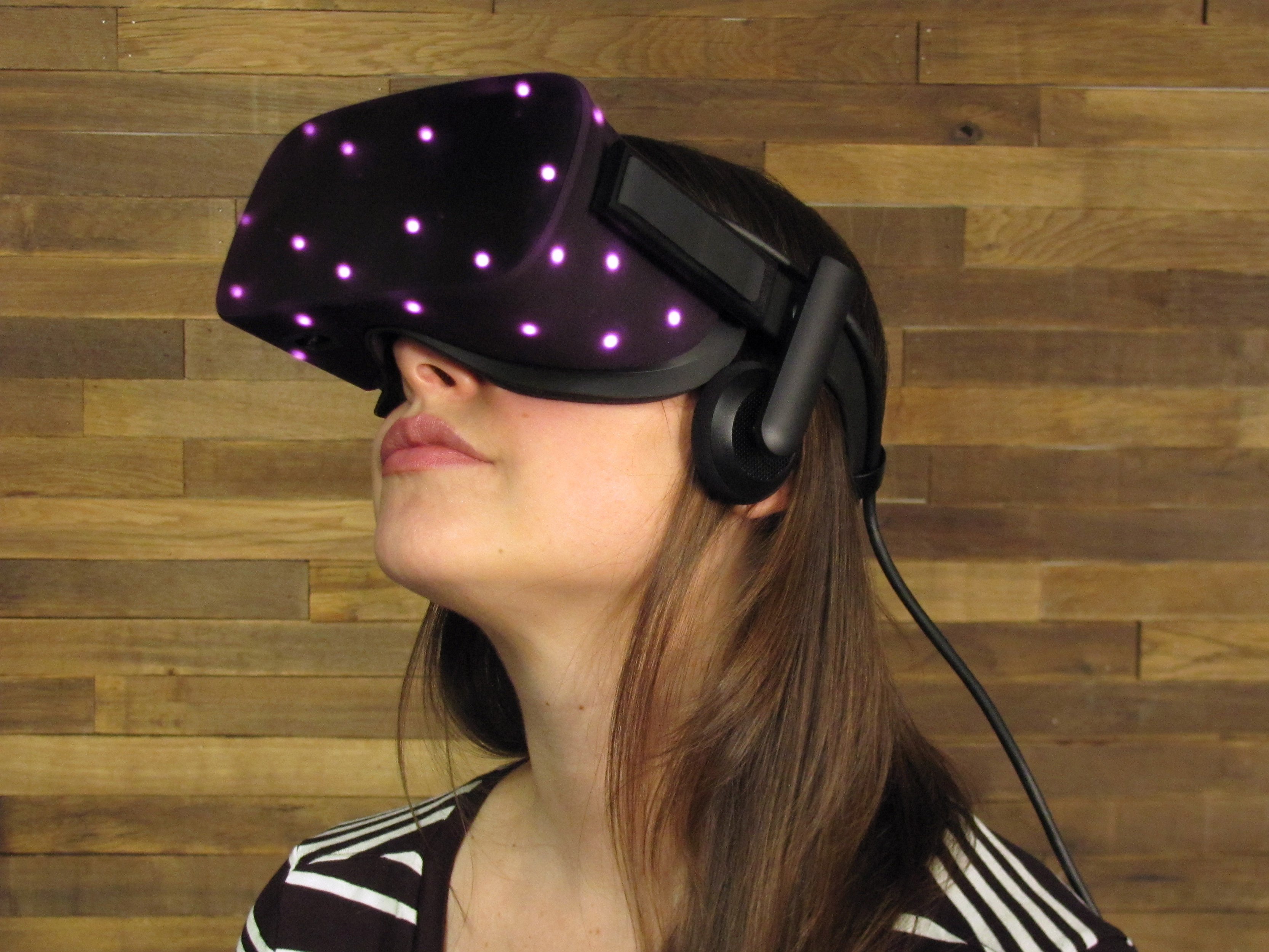
In VR positional tracking aims to determine the yaw, pitch, and roll of displays, controllers, or body parts. Here there are two main options: either sensors on the user keep track of markers in their surroundings, like the Oculus Rift S does, or sensors that surround the user keep track of markers on the user’s body or on the controllers, like the Oculus Rift CV1‘s aptly named Constellation system. Of course, each solution comes with its own set of advantages and disadvantages (and aggravated users).
Methods for motion capture, often used for (CGI) films and video games, operate similarly. The big difference between VR and motion capture is that for motion capture it is acceptable to gear the subject up in special suits with markers, while also often including the finer details of facial movements, something that is less interesting in VR than tracking the movement of one’s digits. You don’t want to spend twenty minutes suiting up just to play a game.
Good Tracking Goes Places
 Whether navigating a celestial body’s surface, the space between the stars, or a virtual reality while flailing wildly in the living room amidst curious glances from your pets, the challenges posed by determining position and orientation remain. Only the actual space that is being navigated changes.
Improved navigation on Earth has led humankind to explore and settle virtually every bit of land on this planet, to create accurate maps, and to locate ourselves in the Earth’s oceans, land, and skies with ever-increasing precision. Over time we learned to create our own markers in addition to the Sun and stars, using light houses, radio beacons, and ultimately a constellation of satellites to enable navigation.
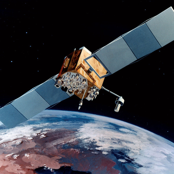
In space, our probes don’t just navigate by stars alone anymore either. The NASA Deep Space Network provides both communication and tracking services to any spacecraft inside our solar system, and beyond. At this point in time, only the network’s largest 70-meter antenna can still communicate with and track the Voyager probes as they venture ever further into deep space.
It’s an interesting inversion that what allowed early sailors to navigate the seven seas and later space probes to navigate the solar system is now used to keep track of you in your living room as you explore the worlds that exist within our collective imagination.


Good article, great art!
The paragraph about astrophotography is a bit misleading. Current telescope mounts still need polar alignment and timed rotation (note: the rotation speed does NOT change with the user’s location). The camera-based tracking function (autoguide) is an additional feature that helps achieve more precise tracking and it is normally employed for long-focal and long-exposure astrophotography. Additionally, the mount in the figure, despite the name, does not use any camera-based tracking. It just uses the good old “pivot and rotation” approach.
Thanks for that about the rotational speed. Of course it needs to turn only once per day. :) Fixed.
Thanks for the info
A fascinating method of star tracking is the so-called astrometry method, described by https://arxiv.org/abs/0910.2233 Basically, take any four or five bright stars, compute their relative shape (i.e., only the angles between them), compute a hash function, and look it up in a table of previously-computed hashes from a star catalog. It’s brilliant.
And if you want to skip the tedium of rolling your own for your cubesat, just call up our good friends at http://www.sinclairinterplanetary.com/ and they’ll be happy to fix you up with one (though you’ll be dealing with Rocket Lab soon, as they’ve just bought them). They can provide you with a set of reaction wheels to fit, too.
The PDF of that paper is very nice and has all the details. Thanks.
That’s amazing! Thanks
There’s star-tracker code available on the ESA website for the Tetra tracker that also uses hash functions
https://github.com/esa/tetra3
And a simulator you can use to generate data for star-tracker evaluation
https://kelvins.esa.int/star-trackers-first-contact/scripts/
That’s excellent! Thanks very much for the references.
However, tetra3 can only used for large fov, build database for small fov is difficult.
Motion tracking isn’t just good for movies and games, it can be used in medicine to understand musculoskeletal problems. I used to use the same kit used to record Andy Serkiss as Gollum to perform walking gait analysis on kits.
The antenna don’t have to be that accurate for receiving, the beam width at a couple million miles has to be really wide. Transmission is a different issue, but beam width is still going to be pretty big, but quieter signal wise
This is a common misconception. It’s the same problem either way. The gain of a directional antenna is the same, whether it’s receiving or transmitting. Concentrating your “listening power” to as restricted an area as possible is just as important as concentrating your talking power. Just as you want to avoid sending your transmitted signal in directions other than directly at the receiver, on the receiver you want to avoid receiving signals or noise from any direction than directly from the transmitter. In any case, when you’re using very high gain antennas, these are physically large, and deep space craft invariably use the same antenna for transmitting and receiving.
But you’re right about the other thing: it’s ANOTHER common misconception, it’s difficult to track the tiny Earth at great distances. The precision needed in positioning has nothing to do with distance, or the size of the target. It is determined ONLY by your antenna’s beam width. If you need to stay within the portion of your antenna pattern that is less than 0.1 dB down from its maximum, and on your antenna, this point in the pattern is 0.2 degrees wide, then you only have to be positioned within 0.2 degrees, regardless of how tiny your target looks. You don’t even need to SEE the Earth, as long as you can identify stars, and know where the Earth must be, relative to them. Which has been a solved problem for many decades.
Nitpick: the longitude reward clock was invented in the 18th century, but the clock wasn’t practical until the 19th century because it was too expensive to have and only barely reliable enough to tell you any better. They were still struggling with temperature compensation and the escapement mechanisms very late in the 18th century, so most ships used lunar calendars instead. The practice of having a clock on-board became common when the Royal Navy began to issue standard chronometers to ships in 1825 and the board of longitude was disbanded in 1828 having filled its purpose.
Typical politicians, kept drawing pay for 3 years after the Navy was issuing clocks. They screwed Harrison, too.
Another nit pick, ‘dead reckoning’ comes from deduced reckoning, so not really dead.
Sigh, another HaD writer (hack) deleting comments. NOT 19th century. Still 18th century.
Yes, it’s kind of sad that mean-spirited commenters cause authors to butcher their own stories because of a simple error.
HaD owns the place: it’s correct and appropriate they should delete abusive comments — content like that is corrosive and does nothing but poison the community. But it’s too bad the author responded by carving big chunks out of the story and makes it confused and disjointed as a result.
Dude. Calma te. It’s not mean-spirited to correct a factual error. My comment wasn’t abusive. And the author never corrected the error. What is your major malfunction? How have I corroded or poisoned your community? It’s sad that people are allowed to talk nonsense like you’re doing. What’s the deal, not quite ’tistic enough to be a Wikipedia editor?
The inventor of the chronograph which is essentially a pocket watch died in 1776. So yes, 18th century. Apple computers used to be expensive too. It’s irrelevant.
The question wasn’t about when the chronograph was invented, it was a question about when the problem of measuring the longitude was solved, and it wasn’t really solved until the 19th century when clocks became cheap and accurate enough that other methods fell out of favor.
You’re simply arguing past the point.
The question of clocks as a means to navigation wasn’t really solved -until- the 19th century because a) industrial methods made clocks much cheaper, and b) the reliability and accuracy of clocks was still too poor to be of much use during the 18th century. Instead, most ships used lunar almanacs until about 1825 when the Royal Navy began issuing navigational clocks to ships as a standard.
The difficulty was, that in the beginning you had one very very expensive clock in the ship, in a gimbal suspended box to reduce the errors, and the navigator had to pop in to check the time, then pop back out to sight the sun or celestial objects etc. to tell the local time. Correlating the two was tedious and inaccurate, and if the clock was bumped or ran badly there was just one of them so you couldn’t know.
So what happened in the 19th century, watchmaking became cheaper and ships started carrying up to three clocks for redundancy, and the deck hands would have pocket timers or “hack watches” that were set from the master clocks, so the resolution of longitude estimation got many times better to the point that it beat the old lunar almanacs.
The whole point of the Longitude Prize, which was one by someone who died in the 18th century, was that the clock didn’t “run badly”. So no.
The board of longitude that awarded the prizes wasn’t disbanded until 1828 when it was deemed that the question was finally solved. They were reluctant to give the prize to John Harris, because while they recognized that the solution was obviously going to be some sort of a timekeeper, he did just barely pass the bar.
There’s a difference between solving a problem and solving a problem – kinda like how you can point out that electric cars have existed since the late 19th century – it’s A solution – but it’s still not a solution.
You may think of the Longitude Prize as proving a concept – that you can make a clock that runs accurately enough and a procedure to use it for telling the longitude to some precision – but there’s a long way from the concept to being practical.
The information on the astrolabe is wrong (it wasn’t invented in 200 BC) and misleading (it wasn’t used for navigation, though the mariner’s astrolabe, invented in the 15th century was). Moreover, astrolabes were not intended to find the angular separation between celestial objects and then to determine latitude. In fact, to use an astrolabe you first needed to know your latitude and to select the appropriate plate for that latitude. Perhaps the author is thinking of the mariner’s astrolabe, which was intended to find the celestial elevation of a known star (and could help in determining latitude).
A nice primer on astrolabes is here: https://dhayton.haverford.edu/blog/2012/02/07/epamphlet-guide-to-the-astrolabe/
On astrolabes and navigation, see: https://dhayton.haverford.edu/blog/2019/07/23/astrolabes-navigation-redux-again/
On the difference between astrolabes and mariner’s astrolabes, see: https://dhayton.haverford.edu/blog/2015/07/22/astrolabes-or-mariners-astrolabe-a-primer/
You are corrosively poisoning the community with your facts and stuff.
Don’t forget the experimental pulsar based location systems: https://en.m.wikipedia.org/wiki/X-ray_pulsar-based_navigation