For those who like to muck around in boats, there’s enough to worry about without wondering if you’re going to run aground. And there’s really no way to know that other than to work from charts that show you exactly what lies beneath. But what does one do for places where no such charts exist? Easy — make your own homebrew water depth logger.
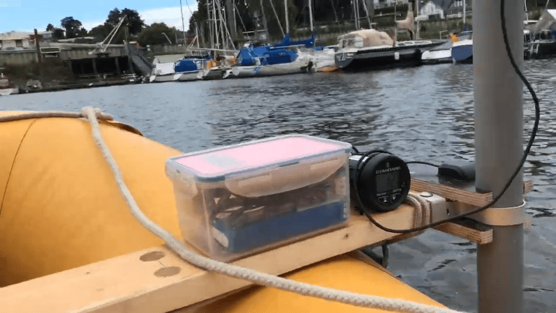
Thankfully, gone are the days when an able seaman would manually deploy the sounding line and call out the depth to the bottom. [Neumi]’s sounding rig uses an off-the-shelf sonar depth sounder, one with NMEA, or National Marine Electronic Association, output. Combined with a GPS module and an Arduino with an SD card, the rig can keep track not only of how much water is below it, but exactly where the measurement point is. The whole thing is rigged up to an inflatable dinghy which lets it slowly ply the confines of a small marina, working in and out of the nooks and crannies. A bit of Python and matplotlib stitches that data together into a bathymetric map of the harbor, with pretty fine detail. The chart also takes the tides into account, as the water level varies quite a bit over the four hours it takes to gather all the data. See it in action in the video after the hop.
There’s something cool about revealing the mysteries of the deep, even if they’re not that deep. Want to go a little deeper? We’ve seen that before too.


Good effort. I wish the video had used a narrative rather than a musical soundtrack.
I think it is possible to connect sonar to smartphone (by USB-UART converter) and write logging application for it. Maybe such applications already exists – I have seen such software for Pocket PC in ~2007.
There’s a company called Deeper which makes sonars that communicate over wifi as well. Some of the models even have built-in GPS. Could be interesting to reverse engineer their protocol.
Indeed there is a crowdsourcing project http://www.openseamap.org that makes also use of the contributed deeph measurements to calculate large scale bathymetry maps. While sea and coasts are usually scanned by official and commercial organisations, the soft waters like lakes and rivers that are only in use for canoing are not. I guess this level of detail needs also a volunteer approach to collect such geodata :-)
This young man is an inspiring digital pioneer and I wish him all the best (and especially a quick recovery of his nose). Thank you for your great work!
What depth finder is used that has NEMA output? I’ve only been able to find it on higher end models, at which point they usually become more like plotters and/or fish finders.
Standard horizon depth sounder ds41
Hi. Awesome ! What electronics did you use besides the transducer to measure the depth?
I have a NMEA capable echosounder and a blue tooth GPS receiver
But I would prefer to use my laptop PC
Secondly if possible can you prepare the complete Arduino hardware and software what is the cost and details
I created another video where I explain the process a bit more: https://www.youtube.com/watch?v=FEGzCPppAuI