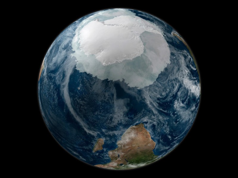
Ever since the first satellites started imaging the Earth, scientists have been using the data gathered to learn more about our planet and improve the lives of its inhabitants. From weather forecasting to improving crop yields, satellites have been put to work in a wide array of tasks. The data they gather can go beyond imaging as well. A new Chinese satellite known as Fengyun-3E is using some novel approaches to monitor Antarctic sea ice in order to help scientists better understand the changing climate at the poles.
While it is equipped with a number of other sensors, one of the more intriguing is a piece of equipment called WindRad which uses radar to measure wind at various locations and altitudes based on how the radar waves bounce off of the atmosphere at various places. Scientists have also been able to use this sensor to monitor sea ice, and can use the data gathered to distinguish new sea ice from ice which is many years old, allowing them to better understand ice formation and loss at the poles. It’s also the first weather satellite to be placed in an early morning orbit, allowing it to use the long shadows cast by the sun on objects on Earth’s surface to gather more information than a satellite in other orbits might be able to.
With plenty of other imaging sensors on board and a polar orbit, it has other missions beyond monitoring sea ice. But the data that it gathers around Antarctica should give scientists more information to improve climate models and understand the behavior of sea ice at a deeper level. Weather data from satellites like these isn’t always confined to academia, though. Plenty of weather satellites broadcast their maps and data unencrypted on radio bands that anyone can access.


“it has other missions beyond monitoring sea ice”
Like spying?
Well, what is old is new. In the 1980’s the USGS Ice Dynamics offices were down the hall from my shop. A polar orbit satellite they used whose name I can’t recall, I think did synthetic aperture RADAR and similar things and could tell how old the Arctic ice was. First year, second year, fresh water, salt water, etc. The calibrated it by flying and dog sledding various places and sampling. (The sat also studied sea surface conditions IIRC.)
This Chinese mission apparently produces “Four feature parameters derived from FY-3E WindRAD orbital observation can not only distinguish between sea ice and water, but also further distinguish between first-year ice and multiyear ice in the Antarctic”. Amazing, ain’t it?
While I was able to debunk all flat earth ‘theories’….
I’ve yet to find ONE real picture from a satelite….just one Israeli company has a service where satelite owners can buy imagines from their satelites to check damage.
If there’s thousands of them up there… how come we don’t have tonnes of pictures of them in orbit?
I’m not sceptic… just find it very unusual there’s NOTHING…
Anyone able to get a clear pic from a sat in orbit? links would be cool :D thanks.
Satellite rarely need to take pictures of their sides, and are usually pretty far apart as otherwise we’d have a Kessler syndrome every thursdays lmao
Treaties were signed with the ice Nazis. That’s why John Kerry and the pope went there, but the UFOs are increasing in frequency.
You can take a picture of the international space station (ISS) yourself. Many people have done it and there are lots of videos of it on the internet. There are also many videos of the star-link satellite launch trains. You can see them yourself in many places if you have the right timing. The ISS is huge and in a lower orbit, while satellites are smaller and often much further away which makes it hard to get a good picture of them.
You can take a photo of a satelite from earh – people do that for fun.
Asume that there are 1 milion satelites placed all over the earh surface – calculate how far from each other they are. Now asume they travel with a speed of sound and higher – how easy is it to get decen image? What is a value of such image?
Now place less than milion satelites o several different orbits and speeds and repeat calculation. 100 000 is just a number – only context makes it big (100 000€ per month is a huge salary) or small (unless you are a clebrity).
“Space is big. You just won’t believe how vastly, hugely, mind-bogglingly big it is. I mean, you may think it’s a long way down the road to the chemist’s, but that’s just peanuts to space.”
If you were to design a custom rifle cartridge with the bullet replaced by a camera, and have two people stand at opposite ends of a football field and fire towards each other, and try to get one camera to take a picture of another camera, that would be significantly easier than trying to get two satellites on intercepting orbits to take a photograph of one another. They also… don’t have any reason to? What would be the purpose?
Incidentally, we already have lots of pictures, hundreds of them, if you care to google, of an object in orbit taken by another object in orbit. Every time a resupply mission docks with the ISS, that’s one satellite taking a picture of another. What exactly are you after?
It’s not really a “space is big” problem as much as a “satellites are small.” You can see the ISS from the ground with a decent telescope, but you’re viewing an object the size of a football field from 250 miles away. Most satellites are much farther away and much smaller.
A communications satellite is probably *at least* 50 times smaller in apparent diameter and possibly greater than 1000 times smaller.
My read of the comment was he wants a picture of one satellite taken from another satellite. Taking pictures of (some) satellites from earth, as you correctly point out, is trivial.
Satellite-to-satellite imaging, even when they’re not docking, is apparently “a thing” now (for damage inspection) – Maxar famously took a photo of Landsat-8 as it passed by as a demonstration of what it can do.
Here ya go:
https://spaceflightnow.com/2020/02/26/photos-servicing-spacecraft-approaches-intelsat-satellite-high-above-earth/
I’m so, so confused as to what you’re asking about.
Do you mean a picture *from Earth* of a satellite in orbit? People do that with the ISS all the time. More typical satellites are way too small to be viewed from ground with any serious resolution, though, unless you’ve got a very large telescope.
I recall a Space Shuttle flight that was viewed by a telescope in Hawaii to look for damage to the heat tiles.
Yup. And shuttles docking with the ISS were pretty common astrophotography targets because it just looks freaking awesome. There’s a famous pic which captured both the Shuttle *and* Hubble as it transited the Sun during the servicing mission.
Agreed! I can’t find one either.. it’s strange.
Pretty sure there’s a few “without editing”. I think I saw one in a recent FTFE/McToon debate where he said “the only editing was to flip it upside down so North America is on top like people are used to”.
Also, compression artifacts aren’t proof of photoshopping.
Thanks for all the informed comments. Really good explanation of why there not (many) pictures.
I’ve seen the starlink ‘train’, ESS but this was bothering me till now.
BIG TNX ;)
When the ice melts, it not only increases the volume of water in the oceans but also alters the distribution of mass on Earth’s surface. This redistribution of mass can potentially affect the planet’s rotation and axis. Just like the weight on one side of the spinning bike, the displacement of ice can cause a wobble in Earth’s rotation, leading to changes in the length of days and seasons that is also how the great floods if time happened and were already witnessing it along the coasts