
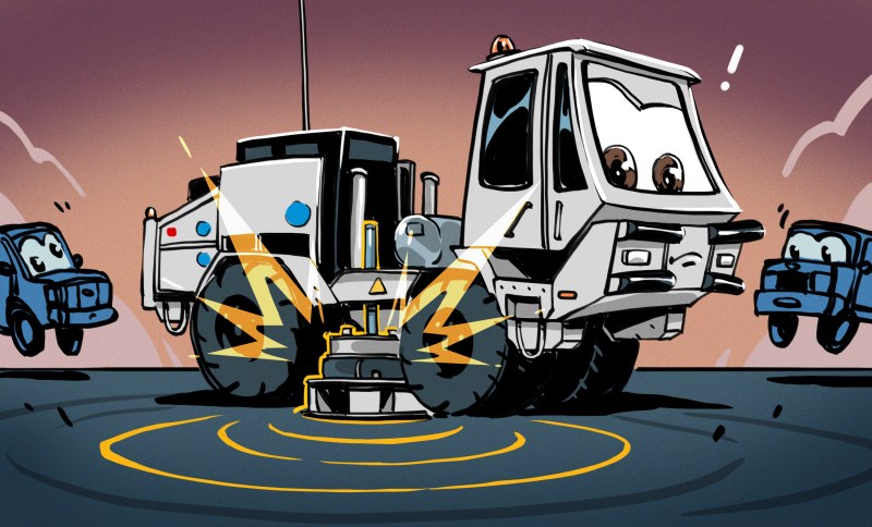
A few weeks ago, my wife was out walking the dog, and she sent me four or five photos of small orange boxes planted all around our neighborhood. (OK, I’ll bite!) They had little cards on them explaining that they were geophones, and a QR code on them that lead to a website with all the details. Munich was getting a large-scale seismic survey to map out our underground water, with the aim of using it for geothermal heat and power in the near future.


How do you map up to five kilometers under the earth? You pound the ground, sending shockwaves downward, and then listen for their reflections. At the boundaries between different layers, the change in the speed of sound in the different media cause reflections. Calculating the time it took for a given reflection to reach you lets you figure out how deep the layer boundary is.
The seismic survey procedure goes like this: geophones are set out at roughly 20 m intervals in lines spaced around 300 m apart that run roughly north-south, while “vibrotrucks” drive a roughly east-west course, creating mini-earthquakes every 20 meters along the way. Covering a surface of 1,000 km^2 with over 120,000 sample locations and exciting them 86,000 times is going to take a while. Lucky for me, they started in my part of town.
Hot Water
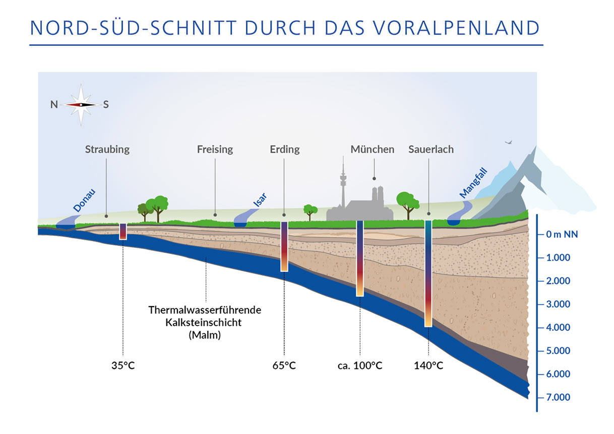
Because the earth is essentially a ball of hot molten metal with a thin and crispy outer crust, and because there is radioactive decay going on even within the crusty bit, temperatures rise as you dig down: roughly 30 °C per kilometer. And Munich has this fantastic source of water that’s folded under the earth in a layer that dates back to the Jurassic, which makes it both low in dissolved minerals and sitting just around 3 km down: at 100 °C. This turns out to be the sweet spot in terms of difficulty of drilling and heat gained from doing so.
Blessed with hot water underground, the question is how to best use it. The plan at the moment is to situate a number of geothermal plants around the city, drill relatively large bore holes at each site that reach down 1 km to 2 km, and then drill diagonally down after that to spider out into a larger source of water. This “extended reach drilling” pulls from a larger heat source, prevents cool spots, and has only recently become technologically feasible.
Which brings us to the GIGA-M study. A 3D map of the underground will help plan out where to put the geothermal plants, in which directions the runners will need to be drilled, and generally how to best coordinate the resource. There were a number of individual smaller surveys done over the last 20 years, and Munich and the surroundings already have a number of geothermal plants, but this survey aims to fill in all of the gaps.
The Hunter and His Prey
It was a Thursday morning when my wife thought she heard some pounding and humming outside. It ended up not being a vibrotruck, but it got us to look at the online map, and while they weren’t in our neighborhood just yet, they were probably within easy driving distance. I threw my camera and tripod in the car and headed out.
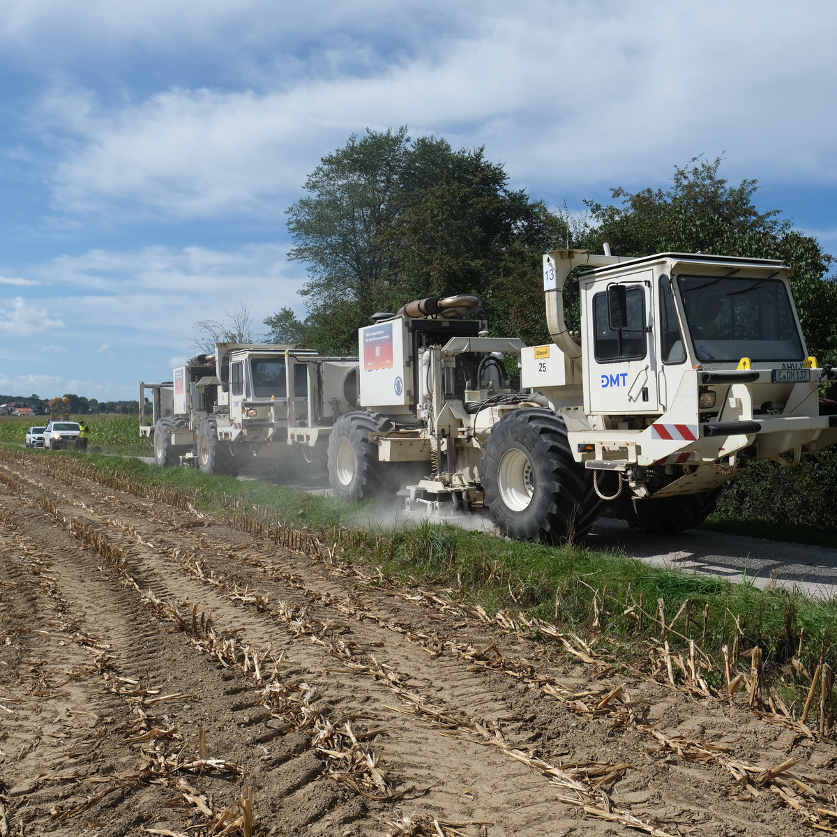
Out in the country, just outside of Grossdingharting (you can’t make these names up!) I spotted a plume of dust rising up from a field. Was it just a farmer tilling? Or was it a vibrotruck? I drove through the woods on a logging road, and when I came out, I was nearly face-to-face with the beasts.
They were loud, and I felt the rumble when I stepped out of the car, so I ran up and asked if I could film it. They said “sure”, and I set up the tripod. The first video I shot, apparently I hadn’t screwed the camera down hard enough in the tripod, and it vibrated loose. So I ran another 20 m further and tightened everything down.
I’m not going to lie: it was exceedingly loud and very exciting. I drove back home and couldn’t wait to review the footage.
The next morning, I heard the same sound outside my own house. They were driving vibrotrucks around in the field about a block up the street. I grabbed the camera and ran out barefoot to get footage. And then Saturday morning, while cooking blueberry pancakes for the family, they drove up my street. Am I stalking the vibrotrucks, or are they stalking me?
An engineer asked if they could stand in our front yard, so I took my chance to bombard him with questions. He seemed stoked to talk about it.
Geophones and Vibrotrucks
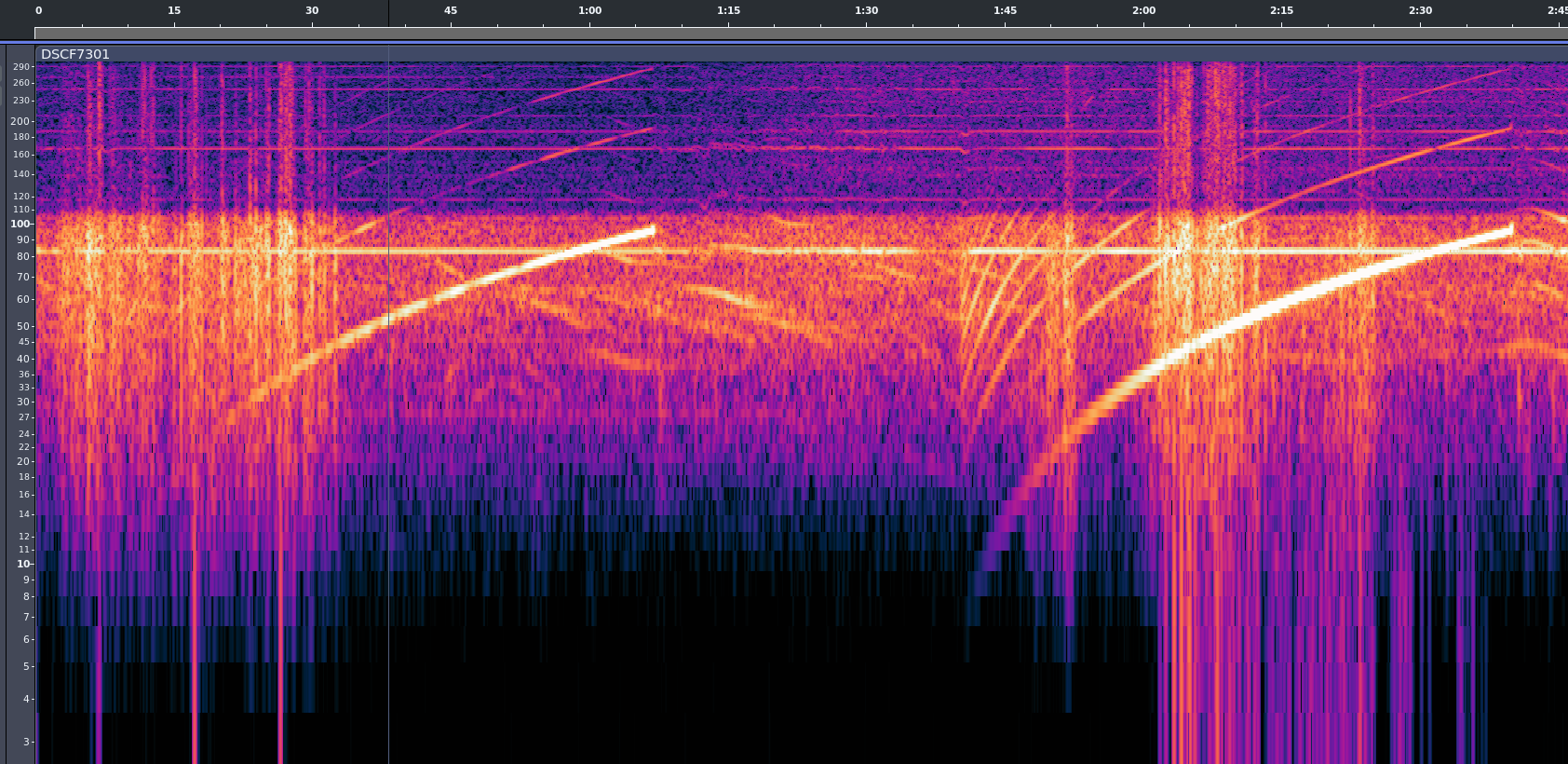 When you stand next to one of these things, first it shakes, and then you can hear a bassy tone, and then it rises and stops. They’re obviously doing a frequency sweep, much like you would use a sonar chirp to help disentangle the multiple reflections from one another.
The sweep means that even if they receive two reflections at once, they will hear two different pitches because one signal traveled further than the other, and comes from the earlier, lower-pitch part of the impulse. It also makes for a very easy to find signature. Correlating these times of flight across the entire array of geophones gives a 3D map of the underground layer discontinuities.
You can see from a cleaned up version of the audio that they’re sweeping from something like 6 Hz up to maybe 96 Hz. The lower end sounds like distinct hammering, and the top end a humming. Here is another video, with filtered audio. Because you feel the vibrations through your feet and in your chest, the live experience is a little bit like this with more noise. Play on good headphones or with a subwoofer for maximum effect.
Of course, the time of flight matters. I asked if each geohpone had a GPS timebase, and the friendly engineer told me that they individual geophones don’t – too expensive – but that when they install one, they connect it to a laptop with GPS that records the location and sets the geophone’s clock. When they harvest them, they record the location again, dump the time to verify that the clocks haven’t drifted too much, and then pull down all of the recorded timestamped data.


Why do they drive around in pairs? It’s simply because they make twice the vibration. The two trucks are actually synced together in phase, so they emit as one. The trucks have a GPS-disciplined clock inside, so they know exactly when they start each cycle and can derive the time-of-flight to all of the receiving geophones. The rest is math.
He also mentioned that it was too bad that I only got to experience the smaller “urban” vibrotrucks like the one outside my house. I kept my mouth shut – nobody needs to know that I’m a vibrotruck stalker.










This is fascinating. I had no idea these existed, but it makes perfect sense. I’m impressed with their ability to sync up given the nature of the scale of the devices. I just happen to have a bass shaker on my office chair – so could feel the filtered audio version as if I was there.
Ive wanted something like that ever since i had a gamer sound react backpack accessory as a mid-teen. tell us more about the bass shaker on your office chair! :)
It’s a Buttkicker I purchased >10 years ago. It has followed me from home/office all that time.
I had to replace the cheap amp after it was hit by lightning (the new amp is a more modern/tiny thing), and I’ve replaced the cable with a much more resilient one with a braided sheath (twisting the chair around a few thousand times will destroy any standard rubber cable). But beside that it’s the original unit. The actual transducer and clamp is very well built and takes immense abuse.
Paired with good headphones and some DSP software it helps me feel like I have the volume much louder than it is, and doesn’t disturb people sitting around me.
If I turn it up too “loud” my chair rattles like an old civic.
Parts Express is a good site to find them. Search “bass shaker”
It’s many years since I did any land seismic so I’m a bit rusty. The vibe signal is a sweep of frequencies as the author noted. This must be recorded using accelerometers on the vibe plates for each sweep. The source signal for that sweep is then correlated with the trace recorded at the geophones for that sweep. Ideally, this collapses the reflection signal for each layer of sub-surface material to a Klauder wavelet making them easy to identify. I worked on a dynamite crew in land seismic some aeons ago then marine seismic. Same idea, different sources and receivers. Knowing exactly where the source and receivers are and the source signal for each record are critical for data quality. There are a number of processing steps required to get the final product.
A chirp is the optimal filter for correlation. They use it in synthetic aperture sonar and radar, and the seismic stuff is the same. I recall walking into the physics department at my university at the beginning of school some time around 1974 and a big cork-board had very nice detailed diagrams and math and the look of the signals in each step of production to detection to display. All totally new to me that you could do this. Back then nobody studies practical applications of Fourier Transforms and correlation and convolution or deconvolution, outside some specialties. Mainly because the computing power and processing time was far real-time. In fact it was more like hours or overnight. But I was inspired to look into this and found virtually no books or other materials! However, I was acquainted with Robert Forward at Hughes Research and he was always good for info on signal detection schemes and tricks. He sent me a large box full of publications, papers, and NASA docs. This is how it worked before Internet searches and the WWW!
IIRC amplified white noise is equally optimal. A chirp or white noise.
Vibroseis has been used by the oil industry for land hydrocarbon surveys for many years; perhaps the most famous survey was of the Paris basin in 1986 with vibroseis trucks surveying down the Champs-Elysées.
https://www.aapg.org/news-and-media/explorer/from-outcrops-to-the-champs-elysees-petroleum-exploration-in-the-paris-basin/?srsltid=AfmBOooYKv3LjWE3y5gqkfD3jxp580Kifa2A2CWSYZ0LIl7QcDJFJ9_4
Clearly things have advanced significantly since the last time I worked in a geology adjacent job. Back then, seismic surveys consisted of the same arrays of geophones, but the exciter was multiple explosives buried in shallow pits.
My cousin worked with an oil exploration crew surveying locations for explosives and geophones. They would drill holes for the explosives, set them off and send the data back for analysis. A follow up crew would compensate people who had wells that stopped working after all the explosions!
Dynamite is used in areas where it is impractical to use vibes, such as swamps. Marine surveys use an air-gun array towed by a ship as the source. The receivers are either hydrophones contained in streamers towed by the same or a different ship or ocean bottom nodes placed using ROVs.
And vibes in places where it’s impractical to use dynamite: like my front yard. :)
I was gonna ask if they still use dynamite? I grew up in the 70s and both parents worked on a seismagraph (?) Crew looking for oil.. My mom drove a vibrator and my dad was a vibrator mechanic. In places like the swamps in louisiana where the trucks couldnt get too, they used explosives. The info was sent through jugs and cables back to the doghouse which was a big box truck full of electronics. When my mom started, the vibrators were esentially a big farm tractor with a vibrating pad underneath. They then went to the monster truck looking trucks with a 10k lb plate. Both parents are gone now, but i had a fun childhood with all the places we went.
Back in the 50’s my father tracked the underground river which passed by Trieste Italy. They didn’t have this sophisticated equipment. Instead they fabricated little floating explosives. These were placed up river where the river descended underground. Each explosive had a timer. Releasing many of these each timed for a longer period for detonation. Above ground they used seismic sensors and would triangulate the position underground of the explosion. This way they tracked the route of the Timavo river to the sea.
I worked with a seismic crew in a Middle East desert in 1987.
Our geophones were wired together to send real time data to the recording truck.
They were a continuous array for 10 Km with perhaps 48? 96? geophones for each 100 m.
We used 4 seismic trucks, yes larger, and synced
Our geophones had to be buried a few inches below the ground to avoid wind noise.
Begging to be used for a sub at an outdoor rave, just port bass into the computer instead of the sweep.
It must drive all the worms up to the surface for miles. Let’s go fishin.
Having worked in oil exploration, when we switched from weight drop to vibs I wanted to turn it into a sub- woofer as something to do when we weren’t out in the field. But the base manager said no. I used to do VSP surveys, initially in the north sea before being sent to the middle east I then transferred to marine seismic. Some of the larger vibs look like something out of a sci-fi film. Great fun to drive the larger ones could do 80kph on tarmac. I remember the smaller ones we used actually bent in the middle for steering and you steered using the brakes and steering wheel. You had two break pedals so it steered a bit like a hybrid tank. The whole cab turned in the direction you wanted to go. Fun times.
I heard a fascinating talk given by a Caltech scientist who has figured out how to use existing fiber optics networks instead of the detectors mentioned for monitoring earthquakes with phenomenal resolution. Another Caltech colleague has used the technique to monitor ice movement in Antarctica. Really neat stuff.
Instead of monitor, I should have said ‘image’, as they could generate images of ground movement vs. depth. They could see the movement of the ice sheets relative to the continent without drilling holes, etc. They could also track individual trucks moving down the freeway of LA
Or maybe they could track subway cars. My memory is a bit fuzzy.
My former company used fibers down old wells to track frac fluid movements. Slight movements of the fiber can be easily logged and 3D movies made of the results underground. We also used electro-magenics to do the same using a high voltage signal source and hundreds of receivers to do the same. Underground fluids could be tracked to about 10 thousand feet. It’s also useful for looking at carbon capture in salt domes to track gas movements.
Did you gather up all the worms that came out of the ground? Free bait!
If you walk without rhythm…
Summon a Maker!
Now i feel a need to build a neighborhood size subwoofer again.
Better find out how to connect one of these vibro-trucks to your amplifier. Bring your bass also.
Worked on the development of the electronic/hydraulic controls for the first of these articulated trucks back in the early 80’s. The company had a “pad” where they tested them that was on the far side of a large parking lot to minimized the shaking of the buildings. The mass was 4 tons and they normally ran 4 to six trucks with a syrnconized frequency sweep. There was one time during development that the control ran open loop and the truck bucked across the lot like a bronco in a rodeo. That particular company was a pioneer and had actually invented the geophone back in the 1920s. The original ones were the size of a small bucket and so those who deployed them were called “jug hustlers”.
Now mess with them by moving a bunch of those microphones a few meters in random directions. :-D
Random noise is just going to cancel out. You have to move them all 2 m due West to be truly evil.
But seriously: some are painted and staked, some on the sidewalks are zip-tied to streetsign poles, etc. And they have a note on them saying “please don’t”.
I suspect some folks will pick them up and move them anyway out of curiosity anyway.
i just spotted one of the geophones in Amsterdam next to the exit of the station muiderpoort and asked myself what they were. as i was in conversation with someone, i did not take a closer look.
but knowing that Amsterdam is actually a floating city on a thick 20mtr layer of swamp, covered with a thin layer of sand, I would not want to sit on one of those vibrating trucks or stand near them. i might drown. :-)
In The Netherlands it is SCAN aardwarmte (https://scanaardwarmte.nl) who combines this with old oil exploration data from the 1980’s for geothermal energy. They actually used dynamite for most of the shots (at least here in de Bijlmerweide, at about 150m from houses) and vibrotrucks in inhabited areas. The geophones were the same model as in your first picture, and they were remote enabled. The have been here for months, the had a LED that blinked every minute or so, but I frequently saw a car from SCAN pass by at evenings and then they flashed every 5 seconds.
They also flashed (even in standby) when you picked them up!
I was never able to see the vibrotrucks or dynamites in action. I mailed the company and they wouldn’t share their planning. So thanks for this article!
A few years ago they put in a townhouse development on a plot across from our house. The plot was sharply sloped, so they had to build a retaining wall and pack earth behind it. To do that, they used a big Caterpillar-brand vibratory compactor.
This thing vibrated at about 32Hz, and apparently that was fairly close to a resonant frequency for certain parts of our house. Outdoors, you could sense it, but in certain parts of certain rooms, it was intolerable. And the work went on for weeks.
I suspect it may have caused some structural damage to our foundation, but don’t have before-and-after surveys to prove it.
Hehe, being a kid at university with a powerful stereo and a WaveTek generator borrowed from the physics lab, I discovered my dorm room had a sharp, strong resonance at 40 Hz.
And my room was one of a hundred identical rooms in the building: Four floors and fifty meters away it was just as intolerable as in my room, and nobody could determine its source.
It would not be hard to make a structure like that uninhabitable with a just few dozen watts of acoustic power.
Geoacoustics is an interesting field, the other day I was using a sonar app, that I built for my android phone, to detect the standing water level in one of my water bores but I kept getting readings that didn’t makes sense, it turns out that a Harley Davidson on the road 250 meters away was setting up a resonance that made the bore seem 4 times deeper than it actually is. I am very tempted to put a full set of different sensors down to the very bottom of each bore, the pump is always >1 meter above the absolute bottom, and have them there permanently logging the changes in every phenomena I can possible detect.
Sonar app sounds interesting too! You should submit some details to HaD
Look for Herrenknecht Urban Vibro, that is your next hunt
My dad used to work for seismic oil exploration companies and they used these trucks closer to town and holes filled with dynamite or ANFO for out in the country.
He’d bring home sales catalogs from DynoNobel on various types of explosives and give away hats with their logo.
I got to see one of these years ago. I didn’t see any receivers but the truck had that big block touching the road. At the time I just guessed at what the truck was so it’s cool to see I guessed correct. Although I still don’t know what the survey was trying to find exactly.
Here in Mesa, AZ while sitting on the toilet, I heard strange noises.
Tones actually. The sewer department lowers a transmitter down one manhole, and listens with a mic at the next manhole. Based on a series of tones and responses they determine if the sewer line has debris, sediment, etc. and if it needs cleaning.
I used to work for the company that manufactured those particular vib trucks. Have been on several surveys all over the world with them. Kinda miss it, was surprised when this popped up on my news feed.
I remember when we had a fleet of these surveying for oil around my home town of Chester back in the 90s. It was fascinating to see (and hear). As a result, we briefly had a huge oil drilling platform built and operating in a nearby field, later followed by a “nodding donkey” – something you’d see in Texas, not the UK!
It was a lot more fun doing it with dynamite :-)
I want one!
These are probably P-wave vibrators. I was always impressed by the S-wave vibrators. They seemed designed to to tear themselves apart.
I experienced the large versions first hand back in the 1980s, when they were used for petroleum exploration. Back then the geophones were hardwired to an EMF shielded recording cab, typically capable of digital sampling 96 simultaneous channels (geophone arrays, an array consists of a number of individual geophones wired in parallel and spaced to phase-cancel the dominant frequency in the surface wave) at 1ms sampling interval. The data was recorded on a 9-track tape drive like you would find attached to a mainframe computer. Which was convenient, because there was only The Computer to analyze the data, a mainframe that took up half a floor in an office building in the city. There was what amounted to a rotary switch that selected which 96 geophone arrays out of the thousands laid out n the survey would be recorded on each sweep.
There would be miles of shielded cable strung out over the countryside to connect all of the geophones to the recording cab. There was a multiperson crew whose only job was to lay out and pick up all of that cable and the geophones, maintaining precise spacing of the geophones in each array and precise distance between arrays. Every geophone location was surveyed with a theodolite and range rod, the latitude ,longitude, and elevation recorded in the surveyors logbook, and flagged, prior to layout commencing. On a geographically large survey, it might take a week to get everything surveyed and layed out before data acquisition could begin.
I experienced the large versions first hand back in the 1980s, when they were used for petroleum exploration. Back then the geophones were hardwired to an EMF shielded recording cab, typically capable of digital sampling 96 simultaneous channels (geophone arrays, an array consists of a number of individual geophones wired in parallel and spaced to phase-cancel the dominant frequency in the surface wave) at 1ms sampling interval. The data was recorded on a 9-track tape drive like you would find attached to a mainframe computer. Which was convenient, because there was only The Computer to analyze the data, a mainframe that took up half a floor in an office building in the city. There was what amounted to a rotary switch that selected which 96 geophone arrays out of the thousands laid out n the survey would be recorded on each sweep.
There would be miles of shielded cable strung out over the countryside to connect all of the geophones to the recording cab. There was a multiperson crew whose only job was to lay out and pick up all of that cable and the geophones, maintaining precise spacing of the geophones in each array and precise distance between arrays. Every geophone location was surveyed with a theodolite and range rod, the latitude ,longitude, and elevation recorded in the surveyors logbook, and flagged, prior to layout commencing. On a geographically large survey, it might take a week to get everything surveyed and layed out before data acquisition could begin.
Did anyone else, watching the vibration frequency sweep, find themselves reminded of current 3D printers doing a similar vibration sweep to compensate for vibration?