
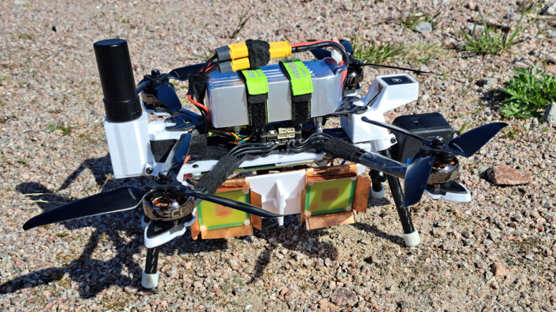
It’s been more than a year since [Henrik Forstén] built the first iteration of his synthetic-aperture radar (SAR) imaging drone, and he’s certainly been productive in the meantime. Not only did he develop a much more powerful autofocus algorithm to clean up the radar images, but he also extended the software to create high-resolution interferometric images.
The main limitation of the original radar system was the GPS, which only had a resolution of about one meter; the autofocus algorithm owed much of its improved clarity to an improved estimation of the drone’s position. A simpler, though more expensive, solution was to add an RTK-capable GPS receiver. RTK (Real-Time Kinematic) receivers use a fixed ground station to constantly transmit a correction signal, letting them reach a couple centimeters of accuracy. Since the drone doesn’t actually need to know its position in real time, it can also use PPK (Post-Processing Kinematic) positioning, which compares recorded GPS signals after the flight to obtain similarly accurate positions.
[Henrik] also implemented a few other hardware improvements, including stabilizing the phase-locked loop used to generate the radar’s frequency sweep. The controller FPGA’s SD card interface had too low a bandwidth to record data in real time, so [Henrik] also implemented a simple, fast compression algorithm to speed that up. Most significantly, he also developed a program for interferometric imaging. The drone flies the same path twice at different altitudes; by comparing phase information from different passes, it’s possible to detect a target’s elevation. Normally, the radar program assumes constant elevation, making tall objects seem to lean toward the radar source; an interferogram, on the other hand, allowed [Henrik] to generate a detailed elevation map.
[Henrik] is no stranger to synthetic aperture radar; we’ve previously covered a bike-mounted iteration and a budget SAR system. If the concepts behind this are still a bit fuzzy, we’ve also covered a guide to making your own SAR setup.










Recent complimentary post by the Silicon Graybeard:
https://thesilicongraybeard.blogspot.com/2026/09/so-whats-synthetic-aperture-radar.html
Wow.
Very impressive.
And illegal pretty much anywhere in civilized world since it’s ITAR restricted stuff for military only. You can get arrested for knowledge of such technology without license.
Huh? Itar for sar?
Mit courseware
https://ocw.mit.edu/courses/res-ll-003-build-a-small-radar-system-capable-of-sensing-range-doppler-and-synthetic-aperture-radar-imaging-january-iap-2011/
Make magazine
https://makezine.com/article/technology/how-to-build-a-synthetic-aperture-r/
So every national surveyor outside the US is breaking ITAR?
“Arrested for knowledge of such technology” sounds like having your hands registered as lethal weapons i.e. made up
If it doesn’t have components specifically registered as it’s, then it’s itar-free. Or you’re assuming only usa can build radars ??
ITAR is US rules for export from USA. The rest of the world have other rules. Henrik is a Finnish guy working in France.
Britain recently designed a few ITAR free long range weapons for the Ukraine. So no detailed US military maps, no US military GPS, older silicon chips sourced from countries other than the US. And most importantly no requirement to satisfy extremely long transfer delays in seeking permission from the US to re-export ITAR restricted items.
ITAR is basically a US control mechanism to keep military technology of the world at least ten years behind the current state of the art, and to restrict resale of duel use items that could be used in atomic bombs. There is nothing wrong with that, I sleep better because of such restrictions. But sometimes the delays and politics involved are so ridiculous, that countries are forced to work around them.
Even a bag of resistors now gets flagged for meta origins :((((