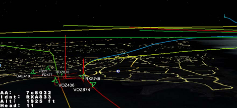
Being an air traffic controller is a very cool career path – you get to see planes flying around on computer screens and orchestrate their flight paths like a modern-day magician. [Balint] sent in a DIY aviation mapper so anyone can see the flight paths of all the planes in the air, with the added bonus of not increasing your risk of heart attack or stroke.
[Balint]’s Aviation Mapper uses software defined radio to overlay RADAR and ACARS messages from aircraft and control towers in an instance of Google Earth running in a web browser. After grabbing all the radio data from a software defined radio, [Balint]’s server parses everything and chucks it into the Google Earth framework. There’s a ton of info, pictures, and explanations of the inner machinations of the hardware on [Balint]’s official project page.
Right now, Aviation Mapper only displays planes within 500 km of Sydney airspace, but [Balint] is working on expanding the coverage with the help of other plane spotters. If you’re willing to help [Balint] expand his coverage, be sure to drop him a line.
Of course, [Balint] is the guy who gave us a software radio source block for those cheap USB TV tuner dongles. Just a few days ago we saw these dongles receiving GPS data, so we’re very impressed with what these little boxes can do in the right hands. [Balint] says his Aviation Mapper application will work with any GNU Radio receiver, so it’s entirely possible to copy his work with a handful of TV tuner dongles.
After the break, there’s two videos of [Balint] sitting at the end of the runway near the Sydney airport watching arrivials come in right above his head and on his laptop. It’s very cool, but we’d be interested in an enterprising hacker in the New York City area copy [Balint]’s work.
Continue reading “Playing Air Traffic Controller With Software Defined Radio” →


