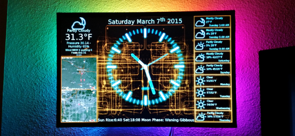
[Kevin] wanted a display where he could take a quick glance and get all the current environmental information he uses throughout the day. That information includes, of course, the time and date as well as weather information. We’re not just talking the current weather information but the forecast for the upcoming week as well as a map showing current weather patterns. To do this, [Kevin] came up with a unique system he’s calling the PiClock.
[Kevin] did some serious programming to get this clock project off of the ground. The weather data comes via the Weather Underground API and the map data from the Google Maps API. The main program is written in Python and will run on any OS running Python 2.7+ and PyQt4. If you’re interested in doing something similar, check out the source at github.
From the project’s name, it is no surprise that a Raspberry Pi is the brains here. A USB WiFi adapter allows access to the internet but an Ethernet connection would do just fine. Having the RaspPi hanging out with wires everywhere would be a little lazy, so [Kevin] opened up his 19″ LCD monitor and mounted the RaspPi inside the case. He tapped 5vdc off of the monitors power supply and used that to power the RaspPi, no external wall wart necessary! And if the PiClock’s background isn’t cool enough, some RGB LED strips were mounted to the back of the monitor to give an Ambilight effect.


