Multispectral Imaging Shows Erased Evidence Of Ancient Star Catalogue

Ancient Greek astronomer Hipparchus worked to accurately catalog and record the coordinates of celestial objects. But while Hipparchus’ Star Catalogue is known to have existed, the document itself is lost to history. Even so, new evidence has come to light thanks to patient work and multispectral imaging.

Hipparchus’ Star Catalogue is the earliest known attempt to record the positions of celestial bodies (predating Claudius Ptolemy’s work in the second century, which scholars believe was probably substantially based on Hipparchus) but direct evidence of the document is slim. Continue reading “Multispectral Imaging Shows Erased Evidence Of Ancient Star Catalogue”

Remembering Virginia Norwood, Mother Of NASA’s Landsat Success

Virginia T. Norwood passed away earlier this year at the age of 96, and NASA’s farewell to this influential pioneer is a worth a read. Virginia was a brilliant physicist and engineer, and among her other accomplishments, we have her to thank for the ongoing success of the Landsat program, which continues to this day.

The goal of the program was to image land from space for the purpose of resource management. Landsat 1 launched with a Multispectral Scanner System (MSS) that Norwood designed to fulfill this task. Multispectral imaging was being done from aircraft at the time, but capturing this data from space — not to mention deciding which wavelengths to capture — and getting it back down to Earth required solving a whole lot of new and difficult problems.

Continue reading “Remembering Virginia Norwood, Mother Of NASA’s Landsat Success”

Multispectral Imaging System Built With Raspberry Pi

Multispectral imaging can be a useful tool, revealing all manner of secrets hidden to the human eye. [elad orbach] built a rig to perform such imaging using the humble Raspberry Pi.

The project is built inside a dark box which keeps outside light from polluting the results. A camera is mounted at the top to image specimens installed below, which the Pi uses to take photos under various lighting conditions. The build relies on a wide variety of colored LEDs for clean, accurate light output for accurate imaging purposes. The LEDs are all installed on a large aluminium heatsink, and can be turned on and off via the Raspberry Pi to capture images with various different illumination settings. A sheath is placed around the camera to ensure only light reflected from the specimen reaches the camera, cutting out bleed from the LEDs themselves.

Multispectral imaging is particularly useful when imaging botanical material. Taking photos under different lights can reveal diseases, nutrient deficiencies, and other abnormalities affecting plants. We’ve even seen it used to investigate paintings, too. Video after the break.

Continue reading “Multispectral Imaging System Built With Raspberry Pi”

Hackaday Prize Entry: Multispectral Imaging Based On LandSat 7

The Landsat series of earth observing satellites is one of the most successful space programs in history. Millions of images of the Earth have been captured by Landsat satellites, and those images have been put to use for fields as divers as agriculture, forestry, cartography, and geology. This is only possible because of the science equipment on these satellites. These cameras capture a half-dozen or so spectra in red, green, blue, and a few bands of infrared to tell farmers when to plant, give governments an idea of where to send resources, and provide scientists the data they need.

There is a problem with satellite-based observation; you can’t take a picture of the same plot of land every day. Satellites are constrained by Newton, and if you want frequently updated, multispectral images of a plot of land, a UAV is the way to go.

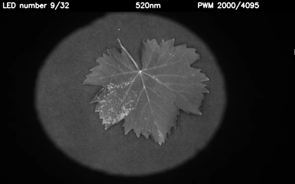
[SouthMade]’s entry for the Hackaday Prize, uSenseCam, does just that. When this open source multispectral camera array is strapped to a UAV, it will be able to take pictures of a plot of land at wavelengths from 400nm to 950nm. Since it’s on a UAV and not hundreds of miles above our heads, the spacial resolution is vastly improved. Where the best Landsat images have a resolution of 15m/pixel, these cameras can get right down to ground level.

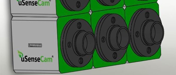
Like just about every project involving imaging, the [SouthMade] team is relying on off-the-shelf camera modules designed for cell phones. Right now they’re working on an enclosure that will allow multiple cameras to be ganged together and have custom filters installed.

While the project itself is just a few cameras in a custom enclosure, it does address a pressing issue. We already have UAVs and the equipment to autonomously monitor fields and forests. We’re working on the legality of it, too. We don’t have the tools that would allow these flying robots to do the useful things we would expect, and hopefully this project is a step in the right direction.


The 2015 Hackaday Prize is sponsored by: