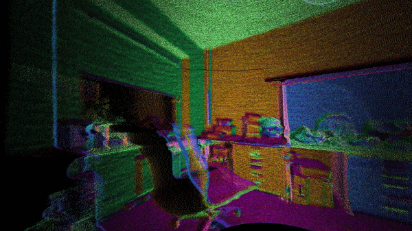
What’s the best way to image a room? A picture? Hah — don’t be so old-fashioned! You want a LIDAR rig to scan the space and reconstruct it as a 3D point map in your computer.
Hot on the heels of [Saulius Lukse]’s scanning thermometer, he’s replaced the thermal camera on their pan/tilt setup with a time-of-flight (TOF) camera — a Garmin LIDAR — capable of 500 samples per second and end up scanning their room in a mere fifteen minutes. Position data is combined with the ranging information to produce a point cloud using Python. Open that file in a 3D manipulation program and you’ll be treated to a sight like this:
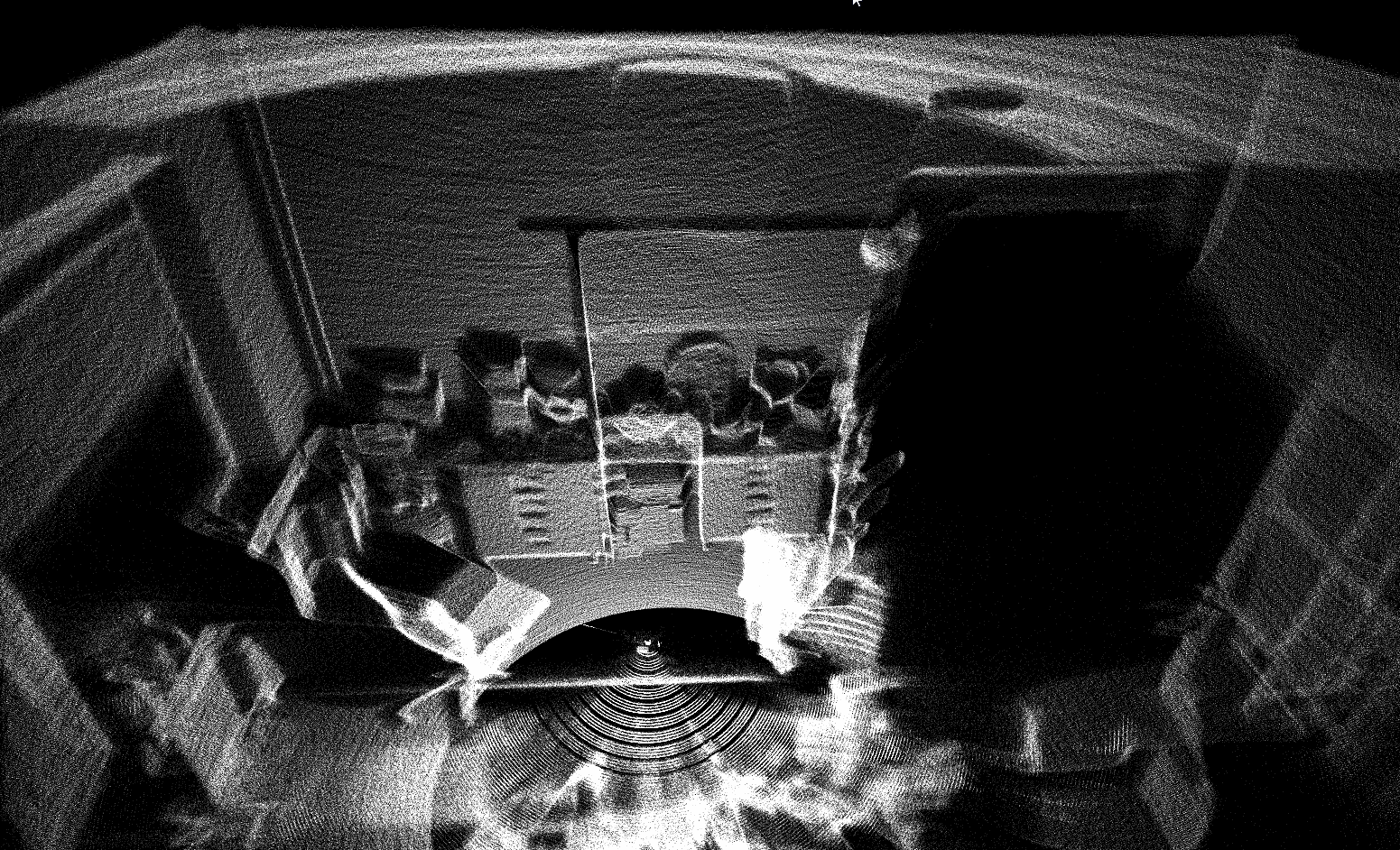
That’s an image generated of a 4.7 million point cloud. It’s not perfect, but it’ll certainly do.
[Lukse] laments that the camera requires ideal lighting conditions that make it unsuitable to for a lot of outdoor imaging and is similarly limited to shorter ranges. It also necessitates hauling a laptop around so he’s considering making it an all-in-one package down the road.
Want to more about how LIDAR works? Check out this teardown video of a police speed enforcement LIDAR ‘gun.’ Or have a look at this (faster) completely DIY laser scanner.


Nice job! I build a first prototype to do the same a few years ago with two main flaws. first obvious and easily to change: I used a 9DOF sensor with resulting Bad angular resolution and lots of drift. Second was the sensor. The moment I find a sensor like in this hack with a resolution of around +-1,5mm I can finally switch away from my unit-e laser range finder with a sample rate of ~0.5 points per second :D
hi
i also want to makee my own lidar sensor with rainging capacity more than 50 metres , will you please help me to design a circuit using laser light
Import into a game engine, and you can make your house into a DOOM level.
Revelant : http://www.smbc-comics.com/index.php?db=comics&id=2158#comic
SCIENCE!
Or import into Blender, then add some floating Suzanne monkeys and a looping Shooting Stars clip.
500SPS * 15Min * 60sec = 450k points, not 4.7M :-)
I think I mentioned in original blog post that it took 15min for rough scanning as you calculated 450K points.
Garmin LIDAR is not a TOF camera. It’s just a distance sensor.. Same incompetent blah blah as always on Hackaday..Not to mention the absolutley exaggerated amount of data points… Get your shit together and add some value to your articles. Quality > Quantity!
How does it measure the distance if not using time. I’m not disagreeing with you, I’m just curious.
Of course it measures time of flight, but it is not a camera.
From the manual at https://static.garmin.com/pumac/LIDAR_Lite_v3_Operation_Manual_and_Technical_Specifications.pdf
“… This device measures distance by calculating the time delay between the
transmission of a Near-Infrared laser signal and its reception after reflecting
off of a target. This translates into distance using the known speed of light….”
So how is this not a TOF camera?
Well, he’s right that it’s not a camera – it’s a 1-D TOF sensor.
To do 2-D or 3-D scanning, you need to move the sensor. (This is what the Scanse Sweep does – it’s just a motor and slip rings and some electronics to determine what the angle was when the Garmin fed an answer back).
In this case I’m assuming he mounted the Garmin on servos – people have been doing that since the LIDAR-Lite first hit the market.
I’m not sure why he talks about “good lighting” – the unit has its own laser emitter and works in anything except ambient with bright IR (e.g. anywhere but outdoors). Even outdoors it works but with reduced range and measurement rates.
It’s not a camera. A camera has enough lateral resolution to create something that can be considered to be an image. This is just a LIDAR sensor that can measure a single distance.
How many sensor elements have to be present to distinguish? I have an old device that claims to be a camera but only has a single row of 300 elements that it then sweeps inside the body along the focal point, is it false to refer to it as a camera?
If he duck-taped 4 sensors in a square, would that count?
So That image of his room was generated not using a camera? Why is it not a camera if the scanning is done mechanically instead of digitally as many cameras seem to scan an image one pixel at a time? Once enough information was gather to generate an image I would say it has become a camera.
If that was true, then a Hassselblad with a scanback would not be a camera either…
Now you just need to selectively reduce common points on a plane to a polygon with a texture map to compress the resulting data in to a 3D mesh ready to use for compositing virtual dinosaurs into live action shots of the room. Or expand the points into true voxels.
I had an idea for a handheld video camera with a laser line view and positioning system to quickly scan in 3D set/scene data more than 20 years ago when Jurassic Park first came out. I should have quit my job and pursued it. /sigh..
Hi,
The sensor does use time of flight but in a rather intersing way. If
you read United States Patent Application 20150260843 by Robert A
Lewis of PulsedLight Inc., (Garman bought pulsed Light in 2016)
it uses a modulated signal which I think relies on Wavelet technology.
The amount of correlation between the wavelette signal sent and the signal
reflected back which has a time delay.
This tweek is significant in that older TOF designs require accurate
pulse diodes for transmit, and more importantly a avalanche boosted
diode on the receiver to time the one shot pulse. These components
are somewhat expensive. The Garmin / Pulselight design subsitutes
cheaper diode components, but adds signal processing wavelet tweeks. Hence
a product with good performance at a lower price.
I was looking a Lighware Optoelectronics before I saw this product.
The next best thing is the TeraRanger products from Europe. However
those need a 12v power supply which can be a bit of a pain.
Best, Mike.
Raster scanning single pixel cameras can easily do the same. These devices collect light sequentially from different directions. Add a laser, measure how much time it took to get there and back. Voilá! You have your 3d cloud. There is a single pixel camera project on kickstarter which plans to have this function.