Anyone old enough to have driven before the GPS era probably wonders, as we do, how anyone ever found anything. Navigation back then meant outdated paper maps, long detours because of missed turns, and the far too frequent stops at dingy gas stations for the humiliation of asking for directions. It took forever sometimes, and though we got where we were going, it always seemed like there had to be a better way.
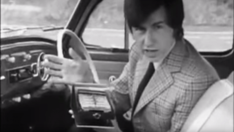
Indeed there was, but instead of waiting for the future and a constellation of satellites to guide the way, some clever folks in the early 1970s had a go at dead reckoning systems for car navigation. The video below shows one, called Cassette Navigation, in action. It consisted of a controller mounted under the dash and a modified cassette player. Special tapes, with spoken turn-by-turn instructions recorded for a specific route, were used. Each step was separated from the next by a tone, the length of which encoded the distance the car would cover before the next step needed to be played. The controller was hooked to the speedometer cable, and when the distance traveled corresponded to the tone length, the next instruction was played. There’s a long list of problems with this method, not least of which is no choice in road tunes while using it, but given the limitations at the time, it was pretty ingenious.
Dead reckoning is better than nothing, but it’s a far cry from GPS navigation. If you’re still baffled by how that cloud of satellites points you to the nearest Waffle House at 3:00 AM, check out our GPS primer for the details.
Thanks for the tip, [Chaffel]
[via Jalopnik]


ETAK was a generalized navigator that stored the data upon cassette, and worked entirely by sensing distance and turns. It was released in about 1985. https://www.fastcompany.com/3047828/who-needs-gps-the-forgotten-story-of-etaks-amazing-1985-car-navigation-system. I had a ride with one in the late ’80’s.
An ETAK is right up there in my “holy grail” category of tech to have in my personal not-quite-a-museum. :)
Already snagged a Pyxis, pending capacitor repair…
Notice how there’s never a side view of the monitor shown? How thick is it?
It’s a vector display, so basically an ordinary CRT of 7 or 4.5 inches. I can only imagine it would be mounted sunk into the dashboard.
On the other hand, they used to have car rallies which weren’t about speed but accuracy. You had to hit checkpoints within small windows. So you needed a good car, and a hood navigator, but you might also add electronics. A receiver to get a time station, for most accurate time, but Wayne Green, when he did rallies in the fifties, had a mechanical calculator on board.
I got a used GPS receiver for a dollar a few weeks ago at a garage sale. Unlike my first two, this one receives well inside. These things are amazing, what was needed in electronics for first generation receivers is incredible, fifty years ago you couldn’t have fit just the radio receiver in something less than a rack, now it fits your pocket. And you don’t have to spend hundreds or was it thousands like fir the first generation, you can pay a hundred. And thy are disposable. I paid five dollars for my first one a decade ago, “it doesn’t do maps” said the seller, then ten for one that did, and now a dollar (though it needs a new battery).
It’s nice to always know exactly where I am, though I still use a map to find my way.
Michael
“they used to have car rallies which weren’t about speed but accuracy”, ” you needed a good car, and a hood navigator”
With a guy strapped to the hood of your car it must have been one hell of a race!
Time, speed, distance(TSD) rallies. They still have them.
I used to love them.
They still do. They’re called regularity or time/speed/distance rallies.
The idea being to get through certain points on a route at a set time, with penalties for being early or late and missing check points and stops. They can be as simple as being given a route to drive and a time to start and arrive or as complicated as only being given a start location and having to work out the route and end location from clues. They can be a couple of miles to hundreds of miles and are open to almost any roadworthy car. Some allow GPS and modern timing and tracking electronics, some will only allow you to use your odometer, a stopwatch and a calculator.
They’re fun.
The AA used to offer this sort of service for members. You told them start and end points along with any specific instructions and they posted you written instructions.
I remember a lady requesting directions to go most of the length of the UK without any right turns. They did it and it was pages of instructions. It was in the papers at the time.
AAA called it a “trip-tik”, which I learned years later was a play on “triptych”. I never used that service, but I remember their paper maps fondly. Before I even got my license, a set of maps (city, state, and national) were a super cool (birthday?) gift, so I could start studying up and learning my way around.
Sounds like one of the people on one of those World’s Worst Drivers shows. He was terrified of making right turns because she got hit by another person who ran a light or stop sign as she was making a right turn. So the show challenged her to plot a route with left and right turns to go to a store and back home. She just could not make a right turn. Ended up spiraling around, left turns only, to get back to her house.
If she went to a country where they drive on the right side of the road, what would she do?
They still do offer it actually. Even today in the age of GPS, I’ll use it. It comes with interesting side bits of information.
Pop Sci ran a regular short XX Years ago. In the 1920’s they had a scrolling map about 2-3 inches wide scrolled by the speedo cable. Good for one long road. The Romans had their odometers with notes made along the way. We can wonder if they “played back” their data discs using them in this manner.
And in WWII there was the Odograph, a US Army map plotting and tracing device fitted to jeeps. They were made by IBM and Monroe and consisted of an analog logic box and an XY plotter unit box.
What’s with all the zebra crossings in the UK? Don’t they have zoos?
We have Toucan crossings too!
Huh… I honestly didn’t know there was a specific name for a crossing for both cyclists and pedestrians. I’d have said Pelican crossing
The wife and I have been watch some Brit. Show and were wondering the same thing.
What the heck are those line on the road?
They are starting to put separate stop lights for bikes in my town with the regular stop lights.
I don’t under stand? Aren’t they (The bikes.) suppose to follow the rules of the road as well?
“Yea I know”. Bikes go thew stop signs and red light all the time. So the city think the bike will stop with there own stop light.
OK
I guess the city staff were getting into the pot early.
So I ask why are we spending this extra money and time?????
I loved the video. So RETRO…
Zebra crossings are beginning to infiltrate the USA, replacing our crosswalks that are two parallel, white lines across the road. Roundabouts are also popping up in all kinds of places.
It’s a plot for the Empire to take back the Colonies… one roadway intersection at a time.
Pelican? As in “Hell! I can!”
They’re really called pelicon. Stands for PEdestrian LIght CONtrolled crossing
PElican is for PEdestrians
But at a Toucan, TWO(types of user)-CAN cross!
And there are also Pegasus crossings (for horses – with riders!)
rolinger – you beat me to it! With the zoos reference, having a Pegasus crossing must surely mean the very best zoos!
And don’t forget, they have “humped zebra” crossings too!
Ahh yes, the sleeping policeman!
Road crossings in the U.K. are very different to the US.
We don’t have jaywalking and crosswalks, instead we have “stop/look/listen” so called because when you want to cross a road you stop, look both ways, and then listen for any traffic you can’t see. This is drilled into children in the U.K. from the age of about 5, so that by their teens they’re able to cross roads safely wherever they choose
Zebra-crossings, So called because of their resemblance to a zebra that failed to cross the road safely, are not places it’s legal to cross the road, but places where pedestrians have *right of way* over cars, and cars have to stop.
Technically in the U.K. a pedestrian already in the road has Right of way over car anyway, but that’s not very safe, so zebra crossings give force all cars except BMSs to stop whilst the pedestrian is waiting to cross.
Pelicon crossings, an acronym for PEdestrian LIght CONtrolled crossing is a set of traffic lights for cars with a red and green man for pedestrians. It’s legal for pedestrians to walk when there’s a red man (unless accompanied by small children, in which case to cross on a red man you have to say loudly “oh, the green man seems to be broken”). Fun fact not many brits know – pelicon crossings have a little vibrating turning knob under them for blind people to hold; it lets them know when it’s safe as they can’t see the green man. It’s also great for stopping kids being bored while waiting for the lights to change.
Toucan crossings (named after the bird which is a bit like a pelican, and sounds like “two can”) have two sets of lights for crossing – usually pedestrian and bike, though pedestrian and horse are seen in some areas.
Zebra crossings usually are accompanied by Belisha beacons, poles at either side of the crossing, topped with a flashing orange globe, which serve to highlight zebra crossings in the dark. They’re named for the Belisha, a small, sadly almost extinct, native British bird which irredescent orange plumage and a perchant for perching at the top of poles.
U.K. traffic lights of all kinds are increasingly getting “bike first” sections – a marked section for bikes just in front of the lights. They do very little for bike safety, but do wonders for the guilt of councils who can thus claim to have added lots of safety projects for bikes, without actually making roads wider, adding bike lanes, fixing potholes, or otherwise improving bike safety.
All fascinating, but I’m gonna ask you to provide some evidence for the Belisha’s existence… ;)
Sadly I can’t as they’re very rare now :P
Ah, I missed that the horse/pedestrian Ones are called “Pegasus” crossings.
Also they’re now putting in “puffin” crossings where the green man is at waist height next to the button, instead of being high up and clearly visible as on a pelicon. They’re really stupid as the green man is much less visible and I’ve missed a cycle several times when a buggy/child has been blocking the view of it.
Belisha beacons were named after the Minister of Transport in 1934 Leslie Hore-Belisha
I’ve never understood the stupid macho bullshit meme about it being somehow ‘humiliating’ to ask for directions. That’s like ‘it’s humiliating to ask a question on Stack Overflow’ , right?
And paper maps weren’t so ‘outdated’ so much, because considerable effort was expended to keep them up-to-date. After all, they were the only way we had to navigate.
No, just very error-prone and confusing when all references were to landmarks only locals understood.
I did piano delivery across California and NV. Never had a problem using paper maps. Then again I paid attention to the roads and signs.
The humiliation generally comes from when you try to follow the directions and get even more lost.
There were earlier prototypes than that. This demo unit from 1965 needs a co-driver in the back – never a comfy place to sit in a SII Land Rover :-)
https://www.britishpathe.com/video/moving-map-display-bagshot/query/land+rover+maps
People forget that there was a “GPS” before GPS.
All the way back with Sputnik, they realized that you can calculate the position of the satellite by the doppler effect on its signal, which in reverse gives you your own position when the satellite’s orbit and the time is known in advance.
That became the TRANSIT system of global satellite navigation. With a constellation of five satellites, you could get your position to within 200 meters once per hour.
A land based global radio navigation system called OMEGA was put in use in the 1970’s which could provide a fix every 10 seconds at an accuracy of about 7 kilometers.
Yet another system called SECOR was put in use in 1964 which was a hybrid where land based stations bounced a signal back from a satellite.
If you loaded up a naval ship’s worth of electronics on board of your car, you could use these multiple signals with dead reckoning to get a reasonably accurate fix for turn-to-turn navigation.
Satire was not indicated;
“People forget that there was a “GPS” before GPS”
One onlyonly sat that if they exercising apple to oranges
“
All this retro-nav talk has me wondering: Were LORAN receivers ever made for cars?
It wouldn’t have been accurate enough. It required the operator to interpret the signal from traces on a CRT, so you would have needed a co-driver to read the display and enter the numbers into the computer, and in any case you’d probably only know your position to within 30 miles with any certainty.
BS alert.
LORAN was good for about 0.25 nautical mile accuracy. No “interpretation” from a CRT needed: Early devices gave you time differences that you looked up on a paper map to find your location. Later devices embedded the ‘map’ and gave latitude & longitude directly.
Where I worked in the eighties we had LORAN-C in a few Cessnas. But everybody used NDBs, VORs and DME (or eyeballs) though, so I never saw one in use. But if you could feed it 24-28V and could put the antenna somewhere, you could certainly put one in a car. At flight level 000 it would certainly work better than the aero nav stuff.
Then how come all the descriptions of LORAN have you fixing to a signal and measuring the timing of a pulse on an oscilloscope screen through a convoluted multi-step process?
And the accuracy depends on your distance from the transmitters, being generally about 2% of your range. For your accuracy to be 0.25 miles, the closest pair of transmitters should not be further than 12.5 miles away, and there wasn’t such a dense network of LORAN transmitters around back then. Of course in some places like along shipping lanes you had.
Not sure, but a friend had a LAURA voice-activated navigation system which sat in the passenger seat and was was very effective.
Though the only location it was ever able to reliably navigate to was the next shoe store.
GPS still sucks. It’s a poor product where I live partly due to design, partly due to greed and partly due to lack of fluency in the local language. Imagine if you will, a country where there are few street names and people through tradition have always navigated by major landmarks. When you reach that landmark, be it a public building, a gathering place or a street corner, they then do the time-honored task of asking the locals “where so-and -so lives”. They then get pointed in the right direction. How do you program a GPS for that? Well, there is a house numbering system and a grid of districts used by postmen to deliver your mail, but there are few street names. Instead, the street corners have names and they serve as the “major” landmarks of any neighborhood. The problem is that they can’t be programmed into a GPS designed for western addressing systems. That means that foreigners who live here must buy a locally made GPS at high local expense and learn enough of the local language and read it in the local writing system (in my case Kanji) to be able to use it. The country is Japan, and as far as I know it is the only advanced country with such an addressing system. This is why you can’t buy Japanese maps for your Garmin GPS, they just won’t work. There have been some conversions attempted, usually an English map force-fitted into a Japanese GPS, but the costs are high and the market just isn’t there to fine tune the software to make them work properly. And then there are the ever-changing roads to consider. Both my cars have Japanese GPS systems, and after a while I do learn how to use them adequately, but I often find myself flying through space on roads that didn’t exist when the GPS software was written. Every two years or so I have to buy an update which costs $200 just for that. More money… Even cellphones have had an impact as only landlines can be programmed into a GPS map, but fewer and fewer people are using landlines these days. I’ve pretty much given up and gone back to using paper maps. It keeps me young…
Japan is the world leader in electronic innovation. If the GPS system doesn’t readily apply itself to the traditional address system is it really fair to blame the computer? As I understand, keyboards are tricky with pictographic languages, do you condemn the model F for similar reasons?
GPS is not SatNav. GPS just gives you the latitude and longitude. It’s up to the device’s software to interpret what your coordinates actually mean.
And the updated map problem is why separate satnavs are becoming obsolete anyhow. Everywhere there’s road construction going on, and you have to keep buying map updates. Cellphones with navigation apps do it automatically.
In the U.S. “GPS” is synonymous with “SatNav”.
I found that out when I wanted to rent a car in England with GPS, and was told that GPS wasn’t available.
Only to find out that the car I did rent had “SatNav”.
Many Garmin models name/numbers end with “LM” which means “Lifetime Maps”, hooking the GPS (SatNav -Jenny) up to your computer will allow one to get free map updates.
“Imagine if you will, a country where there are few street names and people through tradition have always navigated by major landmarks.”
I thought you were talking about Boston…
And eventually, every street ends at the Charles.
“I love that dirty water!”
I have meber had a problem with using GPS in Japan for the 5 years I have lived here.
The ‘lot-block-district’ numbering system, although a bit chaotic, isn’t impenetrable by any means. Heck, even Google maps gets it right 99% of the time.
I drive all over Tokyo and Chiba and don’t have any more problems with GPS than you would expect anywhere else in the world.
*never had a problem.
Need that edit button!
I’ve heard that in Tokyo, they number buildings along a street by the order in which they’re built, not their relative location on the street.
GPS – I don’t think the word means what you think it does.
Your problem is not with GPS at all, but with trying to use a product for a purpose it’s not meant for and with low-quality products. These products just happen to include a GPS receiver. To get sat-nav in Japan, you can go through all the good you have described… Our you can just use Google Maps. Won’t help you with people giving you the nearest landmark instead of a precise location, though.
I use the term GPS as an umbrella term for all dedicated navigation devices such as those in cars and standalone GPS devices. Cellphones and computers are different animals. They too, don’t work well, at least not in my experience, as the programs I have tried don’t translate Kanji to English well enough to make them truly useful. Even Google Maps only translates some of the Kanji, not all of it. There may well be other programs that do work well, I just haven’t found them and I’m too cheap and impatient to download a bunch of them just to find the one out of twenty that actually does work. The real secret is to learn enough Kanji, Hiragana and Katakana so you can use use your cars’ “nabi” systems in their native language. This is not a problem for most other countries as you generally just change the language setting in your device to your preference and off you go.
Until very recently, newspaper delivery folks would make their own turn by turn audio tapes as well. It allowed rural/suburban substitute drivers to fill in for the regular driver. I suppose somebody still gets home delivery of newspapers.
I feel sorry for folks who can’t navigate without a computer and GPS. It’s like one of those Sci-Fi stories where the people have become so brain dead they can no longer function without machines making decisions for them.
We all are getting dumber.
https://www.fastcompany.com/40584777/were-all-getting-dumber-says-science
Every once in a while, when time isn’t of the essence, I’ll go GPS-less on a long trip, and see if my sense of looking for a sign “after about 45 minutes” still works. It’s functional enough, but I find myself getting stuck in a lot more traffic that the navi was silently routing me around.
I still keep paper maps of the states I travel frequently, and a national map, in my car’s emergency box just in case.
Me too, except the other way around. I only bust out the GPS if my senses fail me :)
It wasn’t that bad back then. People and businesses had standard sets of directions from well known starting points and they would give them to you when you arranged the visit over the telephone. This was all figured out prior to leaving.
You’d only need to pull over and ask Bubba if you screwed up or were visiting a directionally challenged person.
I remember some German auto makers (maybe Mercedes-Benz?) experimented with an in-car navigation system back in the 80s. They would install infrared transmitters into all intersections in large German cities and there was a receiver in the car. It would read the signature of the intersection transmitter and by that know where it was. I don’t know if the route was pre-loaded somehow or how it worked, but the location part is very simple.
I love the ingenuity in these early systems of automated navigation. I had heard about these and enjoyed the read.