If your only experience with Garmins is from that one rental car a few years back, it may surprise you that some of them, mostly the handheld outdoor units, allow custom maps. This sounds cool until you find out the limitations. Unless you upgrade to premium, it doesn’t allow map files larger than 3MB. What’s worse, it will choke the resolution of maps larger than one megapixel. Well, bust out your virtual hiking boots, because [facklere]’s gonna take you down the trail of DIY digital cartography.
You can use any map you want as long as its not completely fictional (although wandering the maps of middle-earth would be a fun hack on top of this one). Your map can be paper, PDF, or parchment; it just has to be converted to JPEG. The map [facklere] wanted to use was a huge PDF, so as a bonus, he shows how to get from PDF to JPEG in GIMP. Then comes the fiddly part — rooting the map in reality by overlaying it on real roads using Google Earth.
You’ve still got a huge map. Now what? The secret sauce is tiling. [facklere] used KMZfactory, a free map editor for Garmin maps that goes the extra mile to split the tiles for you, keeping them under the 1MP limit. Once that’s done, just upload it to your unit and hit the road.
Got an old Garmin that won’t do custom maps? See if you can get DOOM up and running on it.


If your maps are already in a vector format, you can also use mkgmap to convert them for garmin devices. Works great for generating custom maps from openstreetmap data.
A few years ago I considered an app for making more useful the paper maps that you’re handed at some venues (outdoor gardens, theme parks, etc.) i.e. take a picture of the map on your phone, tell it where on the map you are, and then later, after travelling, tell it again so that it can automatically orient and scale the map. I kind of forgot about the idea until now. I wonder if people would find it useful.
It would also be a quick way to find out if the map they handed you was scaled correctly. I have seen some that took a lot of liberty with the geography while pretending to be a real map and not a subway type map.
It might be easier to convince venues to install a GIS server backend that goes to a QR code on the paper map. You could also have a *.kmz overlay that gets imported to the users version of google Earth/maps.
Georeferencing paper maps, even well done but slightly inaccurate maps (eg old survey maps), generally ends up ugly. Unless the paper map maker went to great lengths to create an accurate scale map you’re bound to get unrealistic warps and artifacts as the software tries to fit the map to your digital model. This also takes a lot of math behind the scenes while manipulating big files, users might not like the time it takes for the payout.
I’m sure it would be easier to convince any given venue to install some tech, but I’d like to have the problem solvable when I go to a venue for the very first time!
I don’t anticipate ‘big’ files, although I suppose it depends on your definition. I wouldn’t want to be stitching together loads of shots of a huge map. I’m sure there would be warps, both from inaccuracies in the map, and inaccuracies in the photography.
3MB jpegs are pretty big when you have to apply transforms over the whole picture.
What I’d like to see is the last version of Mapopolis maps for Palm OS figured out, and a converter from Open Streetmap to Mapopolis.
The last maps released for Mapopolis were based on GPS data compiled during the 2000 census, and there was a ton of errors and missing info.
I use the Custom Maps app http://www.custommapsapp.com/ all the time. Take a pic, chose some reference points and you’re good to go. You can even upload the kmz files it generates to your garmin
I navigate around Garmin’s map limits by not buying Garmin.
I only use open source sofware (and donate sometimes to support it).
For maps and route planning I use OSMAND lately.
Just throwing this out there, the US forestry service and USGS have map servers with quadrangle contour maps in PDF. Also most states have some sort of GIS service with LIDAR and elevation models for various parts of the state.
Adding a coordinate system can be tricky but sometimes they come as GeoPDFs that are already projected correctly. Programs like Global mapper ($ but evaluation licenses are free) are pretty easy to use or you can jump into the deep end of the pool w/ QGIS or GRASS which are both free.
I second the comment recommending QGIS. That program has a lot of features that can get hairy, but the process of geocoding an image is actually very straight forward and not difficult. I’ve gotten excellent results with it.
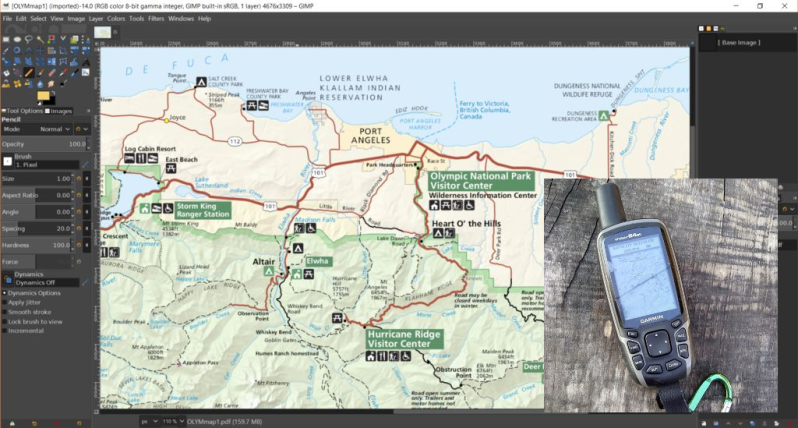
I don’t see in the map of the title photo, mention of my favorite Washington town, Squim!
It’s “Sequim”, just pronounced “Squim” :-P I always tell people about how most states have that one town that only natives know how to pronounce, well Washington has one in like, every county :-P
Washington has one pronounced pew-all-uhp but spelled Puyallup.
If you’re referring to “Sequim”, the proper boundaries of it are, I believe, completely under the Garmin scanner in the picture. :-)
I suspected that, but wasn’t sure.
Thanks!
Mentions KMZFactory, but doesn’t mention that eliminating Garmin’s SEVERE custom maps restrictions that still affect KMZFactory use require using patched firmware?
As someone else mentioned, these days I basically don’t buy Garmin and use OSMAnd instead. My last Garmin purchase was an Oregon 300 a decade ago and I haven’t touched it in years.
I bought a Garmin a few weeks ago.
$5 at a garage sale.
Works for me!
B^)
The open source QGIS can do both the conversion and georeferencing. It’s a great piece of software if you ever need to do anything significant with map data, and I find it a lot easier to use than ArcGIS.
Meh..
https://opentopomap.org/
The OpenStreetMap can be used on Garmin devices : http://garmin.openstreetmap.nl/
One problem with older Garmin devices is they only have 1 or 2 gig internal storage and can only use a 2 gig SD card. There are converters for taking Open Streetmap data and converting it to Garmin’s vector format, but nobody wants to bother doing a conversion that only includes the bare minimum data of streets and names, and addresses to see if the continental USA can still be squeezed into a file that’ll fit on a 2 gig SD.
At best you have to split the CONUS map into halves and use one at a time.
Some of those old Garmins can use a 4 gig SDSC, if you can find any such cards. Most of them were made circa 2005, shortly before the SDHC standard was finalized and the SD standards people gave 4 gig SDSC the thumbs down.
Appreciate this. People I work with use the rugged Garmin GPSMAP 78 for forestry work and we have been struggling lately to produce custom IMG files that draw up data properly, similar to our paper/pdf maps. Was excited about the possibility of creating KMZs out of exported JPEGs but ran into the file size issue loading them into the units. KMZFactory worked like a charm. Will save me countless headaches.