
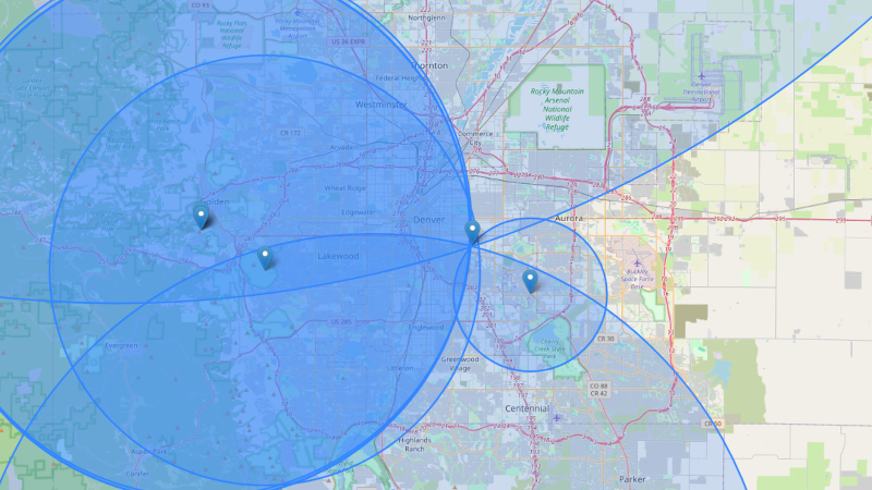
We’re all used to satellite navigation systems such as GPS or GLONASS, sheer magic in which the combination of a set of reference transmitters and super-accurate timing information can be used to calculate a position to an astounding precision. They had land based predecessors such as LORAN and Decca Navigator which worked in a similar fashion but with fixed land-based reference transmitters. Terra is an attempt to do the same thing without a network of dedicated transmitters, instead using FM broadcast transmitters as its fixed points.
This might seem like an impossible task without access to the transmitters, but they have a workaround using the Internet as a backhaul. Instead of transmitting their timing information like the systems mentioned above, they rely on a set of reference receivers sharing it online to the client’s receiver software. So far they have a demo running in Denver.
The interesting thing about this system is that it’s open-source, and requires only a relatively inexpensive software defined radio receiver and a computer to operate. Now anyone with a group of internet-connected friends to set up reference receivers can have their own positioning system, it’s no longer the exclusive preserve of governments. We like this idea, and we look forward to seeing it being tested more widely.
If you’d like to know where we’ve come from, we’ve taken a look at LORAN before.










Presumably this is much harder to jam as instead of a low power satellite a long way away, it’s using high powered transmitters much closer?
APRS, by Bob Bruniga. Problem solved.
APRS uses GPS…. same problem…. Solves the telemetry problem of emitting the GPS to base stations when no cellular is available nicely tho…
Correct. There’s been a bunch of gps+glonass+thatotherChineseone because they sit in the same band and it can get flooded by comms in nearby.frequencies.
Using multiple sources gives failovers.
There is big big big money If they can get rtk grade accuracy (put up your own transmitters). Lot of high $$$ markets for private location services in gmss denied areas
You know, it would be totally possible to add a signal to commercial broadcast stations specifically for this kind of LORAN-lite solution.
Over the years we’ve encoded quite a lot of auxiliary information into broadcast signals for a variety of uses, it ought to be possible to add a simple timing tick to produce a reasonably accurate navigation signal.
I the modern world where GNSS jamming is a real thing, having a backup that was as good as old school LORAN would be nice.
What you’d want to do is synchronize their digital transmission starts: you can’t really add an additional timing signal because you need more bandwidth for that than you’d think – if you think about a 1 PPS signal, it’s transmitting way more information than 1 bit/s, it’s just that most of them are zero. Ideally you’d want to synchronize the carrier, which would give you more precise timing (this is true with GPS as well).
You’d still be more limited than GPS just due to the frequency difference.
If most of the bits are zero, you don’t need that much extra bandwidth to transmit them.
No, because it’s the timing that matters, so it’s really symbols/sec.
Some countries are already deploying fiber backbones to provide accurate time information to transmitters.
For cell towers (mobile phone towers).
Since some weeks (IIRC), we not only know that Russia is jamming GPS and BaiDou in Europe, but which Russian satellites exactly man the GNSS signals.
The Obama administration oversaw the shutdown of LORAN without any definative plan to replace it, despite global reliance on easily jammed GPS. Work was supposed to start on a new one in 2021.
That said, it needed to happen since the LORAN sites were giving all the Coast Guard members living under the antennas all kinds of rare cancers. The high voltage vacuum tubes were producing x-rays. Never mind living at the base of an absurdly powerful HF tower.
Its a shame considering how accurate you could be with LORAN lines on a chart and an analog RDF reciever. Always thought they should expand and enhance the VOR beacon network used for aviation to ships and ground traffic. Just need to find a solution to it being line of sight VHF. Maybe NVIS bounce?
x-rays could cause cancer but being exposed to radio waves can, at worst, slightly warm your body (particulary at microwave frequencies). extra credit for that moment of thanking Obama!
HF antennas can cook your eyes and reproductive tissues with comparatively little exposure.
Antennas on military ships have bright red lines painted around them with e posure warnings. Aircraft aren’t allowed to energize certain radios while on deck for the same reason.
Coast Guard ETs have to keep a radiation expoaure log for all the time they spend near energized systems. Once they fill that card up they’re not supposed to go near operational antennas anymore.
Also, wasn’t blaming or crediting Obama, just wish someone in his admin had pushed for a safer repalcement.
“LORAN sites were giving all the Coast Guard members living under the antennas all kinds of rare cancers”
Do you have any source/s? I’m interested.
Thanks!
This is the PDF from 2011 talking about the x-rays
https://www.dtra.mil/Portals/125/Documents/NTPR/newDocs/radiation-dose/DTRA-TR-10-26%20-%20USCG%20LORAN%20Transmitter%20X-Ray%20Exposure.pdf
I cannot find the documents on the other non-cancer or “cancer adjacent” diseases. I was an OS in the Coast Guard and can remember the ET’s talking about the LORAN stand down and ongoing legacy RM and ET rates having long standing legal battles with the VA over service related health issues. Guy I served on a cutter with (2014-2017) said the concerns about low level radiation have been an ongoing issue on the enlisted side for a long time.
I don’t know if the lack of documentation is due to normal VA incompetence or a desire to keep the information out of the public eye similar to the issues with Agent Orange and AO Act in 1991.
Bottom line, you couldn’t have paid me enough to stand LORAN duty.
Thank you very much! Very valuable source and reply, I appreciate your time.
I know some transmitters still use big-ass tubes, likely to produce X rays, but I wonder whether this continued to be an issue after the mechanisms were well understood (and of course after migration to solid state switching).
For example, I recall some tubes are actually designed to limit this (by means pf Pb coats), and even if they weren’t at all, it should be very very easy to manage this radiation. It’s not gamma rays in a reactor, X rays are easy to manage.
You introduced the concept of incompetence, and I can find no better explanation (not on the operators side, but by the management stratum) considering the mechanisms were well understood early enough. What a sad occurrence, this shouldn’t have happened.
Thank you!
The X rays those tubes generated were so low energy to be entirely absorbed by two feet of air, or the cabinet walls. The radiation risk was real if they had their head in the cabinet when the amps were running full power, But the high voltage would have been much worse. The risk was zero in the next room.
The asbestos in the buildings was a much greater concern.
And anecdotes of cancer risk is not statistical data.
Thanks Obama.
How would you avoid requiring each transmitter to be equipped with an atomic clock? (Possible solution: Have each one receive the signals of the other transmitters in the area for synchronization, and transmit only relative timing information?)
The carrier’s going to limit you, so just having them be network time synced is fine. You’re going to have to rely on several sources anyway.
KiwiSdr allows multiple simultaneous connections to remote HF receivers via the internet to triangulate a transmitters position.
Can FM signals pass through the 787 Dreamliner’s electrically dimming windows? GPS signals have an issue it seems
Why is this important?…a 787 is not that big inside. Do you foresee someone getting lost on a 787 and needing navigation services?
For the aircraft’s own navigation, the antennas are external…
I want to know the route its flying on my own device as a passenger
Sit to window, start gps app (with offline map) on your phone, put the phone near the window and you should have a fix. GPS test app shows nice 950 kph. By the landing you will have usually the data too and it is fun to observe landing on Google map.
Had some hilarity running Microsoft Streets And Trips on a laptop at 35,000 ft (in about 2003). It insisted I was a car doing 500 mph, and desperately tried to keep the car icon on roads. It got completely mystified west of Nebraska (where we’re going we don’t have roads).
And my Garmin eTrex got very confused at 45 degrees West, just south of Greenland, thinking there was a perfectly straight north-south shore at that longitude.
There’s a reason aviation-grade GPS devices cost more, maybe. I hope it’s because they have fewer bugs.
Except that 777 I was in showed us taking a stair-step flight path coming over Canada. I swear I never felt those hard 90-degree turns every 50 miles.
Simultaneously capturing multiple FM stations is easy enough (particularly with an SDR), but getting precise correlation using the Internet seems like an infrastructure stack problem. It’s all fine and dandy when everything’s working, but it won’t save you when things stop working well.
See https://www.cambridge.org/core/journals/journal-of-navigation/article/abs/cursor-radio-navigation-and-tracking-system/D5FC860E9A0E038F06EEA9946509EC83
Years ago I tried this the low tech way with a radio, a small loop antenna and a compass.
The accuracy wasn’t enough to get the road I was on, but plenty good enough for navigating open country.
I’ve seen a demonstration of how WW1 era old school positioning works in the army. There’s a two man team pulling a 50 yard rope: one guy runs ahead until the rope runs out, then the other guy takes a compass heading along the rope, and catches up. They keep a tally of the directions and distances on their map, so wherever they stop they can calculate the shift relative to the starting point.
Every time they come across a fixed point on the map, like a farmhouse or a bend in a stream, they zero their position there and start pulling the rope towards where everyone else is heading. If the group gets an enemy contact and stops, the navigation team catches up from behind and tells the leader where they are, so they can call in artillery on the enemy without hitting themselves.
Though of course they still have to wait for the third guy who’s coming up from behind with a massive cable reel on his back, pulling the telephone cable so they can actually call the strike.
If you have internet access then you have meta data, like IP, ping times…
The new GPS may make it obsolete really fast as these ground station would need power and maintenance which add to the cost. Among other things GPS Block III has a few anti-jamming/anti-spoofing technologies built-in. I can’t wait for it to be fully operational and possibly a u-blox NEO receiver being sold for it.
Considering the number of fixed transmitters out there of all frequencies, one could do a decent job navigating around. Need one heck of a database to go with it.
Using DVB-T/T2 transmitters an auxiliary internet connection might not be needed. Have a look at this conference paper from Linköping University (Sweden):
Localization Using DVB-T Signals: Experimental Insights and Validation
https://urn.kb.se/resolve?urn=urn:nbn:se:liu:diva-218067
ATSC-3 does this.
FM broadcast engineer for a few fairly large markets chiming in here. I have the option to send out time sync info encoded in RDS (Radio Data System, the song title/station information on your dash). All of my sites already have GPS antennas, since time sync is pretty important for encoding and decoding audio coming in from the studio on the other side of the state. I also use it to lock our FM and HD programs together, so the switch between the two if you’re listening on the fringe is seamless. Anyway, with a time sync over RDS, and a known position of at least three (down to two transmitters, if you know your velocity), wouldn’t this be enough to determine your position on the globe? I’m not very experienced in positioning systems, audio transmission is closer to my bread and butter.