The TAK Ecosystem: Military Coordination Goes Open Source

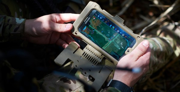
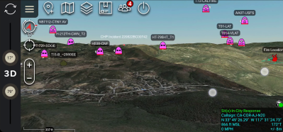
In recent years you’ve probably seen a couple of photos of tablets and smartphones strapped to the armor of soldiers, especially US Special Forces. The primary app loaded on most of those devices is ATAK or Android Tactical Assault Kit. It allows the soldier to view and share geospatial information, like friendly and enemy positions, danger areas, casualties, etc. As a way of working with geospatial information, its civilian applications became apparent, such as firefighting and law-enforcement, so CivTAK/ATAK-Civ was created and open sourced in 2020. Since ATAK-Civ was intended for those not carrying military-issued weapons, the acronym magically become the Android Team Awareness Kit. This caught the attention of the open source community, so today we’ll dive into the growing TAK ecosystem, its quirks, and potential use cases.

Tracking firefighting aircraft in 3D space using ADS-B (Credit: The TAK Syndicate)

Continue reading “The TAK Ecosystem: Military Coordination Goes Open Source”

Hackaday Prize Entry: A 3D Mapping Drone

Quadcopters show a world of promise, and not just in the mediums of advertising and flying Phantoms over very large crowds. They can also be used for useful things, and [Sagar]’s entry for The Hackaday Prize does just that. He’s developing a 3D mapping drone for farmers, miners, students, and anyone else who would like high-resolution 3D maps of their local terrain.

Most high-end mapping and photography work done with quadcopters these days uses heavy DSLRs to record the images that are brought back to the base station to be stitched into a 3D image. While this works, those GoPros are getting really, really good these days, and with 4k resolution, too. [Sagar] is mounting one of these to a custom quad and flying around an area to get images of an area from every angle.

To stitch the images together [Sagar] will be using the Pix4D mapping software, an impressive bit of software that will convert a multitude of still images to a 3D scene. It’s an expensive piece of software – $8500 for a perpetual license, but the software can be rented for $350/month until a FOSS alternative can be developed.


The 2015 Hackaday Prize is sponsored by:

3D Mapping Of Rooms, Again

Last year we saw what may be the coolest application of a Kinect ever. It was called Kintinuous, and it’s back again, this time as Kintinuous 2.0, with new and improved features.

When we first learned of Kintinuous, we were blown away. The ability for a computer with a Kinect to map large-scale areas has applications as diverse as Google Street View, creating custom Counter-Strike maps, to archeological excavations. There was one problem with the Kintinuous 1.0, though: scanning a loop would create a disjointed map, where the beginning and end of a loop would be in a different place.

In the video for Kintinuous 2.0, you can see a huge scan over 300 meters in length with two loops automatically stitched back into a continuous scan. An amazing feat, especially considering the computer is processing seven million vertices in just a few seconds.

Unfortunately, it doesn’t look like there will be an official distribution of Kintinuous 2.0 anytime soon. The paper for this Kintinuous is still under review, and there are ‘issues’ surrounding the software that don’t allow an answer to the if and when question of release. Once the paper is out, though, anyone is free to reimplement it, and we’ll gladly leave that as an open challenge to our readers.

Continue reading “3D Mapping Of Rooms, Again”