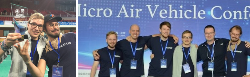
The IMAV (International Micro Air Vehicle) conference and competition is a yearly flying robotics competition hosted by a different University every year. AKAMAV – a university student group at TU Braunschweig in Germany – have written up a fascinating and detailed account of what it was like to compete (and take first place) in 2016’s eleven-mission event hosted by the Beijing Institute of Technology.
AKAMAV’s debrief of IMAV 2016 is well-written and insightful. It covers not only the five outdoor and six indoor missions, but also details what it was like to prepare for and compete in such an intensive event. In their words, “If you share even a remote interest in flying robots and don’t mind the occasional spectacular crash, this place was Disney Land on steroids.”
The eleven missions were inspired by a hypothetical oil spill on an oil platform. They included:
Outdoor Missions:
- Takeoff from a moving and rocking platform
- Live mapping of a mission area to identify targets of interest
- Precise delivery of a life buoy / life-preserver
- Collection and delivery of a water sample
- Landing on the same moving and rocking platform
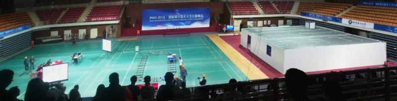
Indoor Missions:
- Takeoff from a moving platform
- Enter a target building from doorway, chimney, or window
- Map the inside of the building
- Pickup and release of specific objects (i.e. find specific objects and move them to designated locations)
- Exit the building
- Land on a moving platform
Multiple drones could be used but teams scored better the smaller the drones were, the more missions were done in a single flight, and the higher the difficulty of the challenges (i.e. choosing to land on a moving versus stationary platform.) Human piloting was a permitted option for the indoor missions, but for the outdoor missions flight had to be autonomous. Overall the less humans were involved, the better the team’s score.
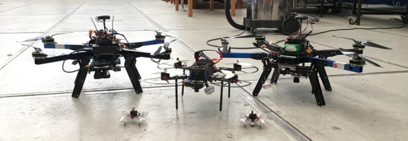
For the outdoor missions, AKAMAV used two identical 550mm quads with 600g payloads. Flight controller was a pixhawk with APM:Copter and an onboard companion PC for other tasks, plus other components as needed. the indoor missions were 60mm Tiny Whoop quads for the starting, entering, and landing portions. The indoor mapping and pickup-and-release missions were handled by a modified 250mm racer using a 360 degree camera combined with Pix4D software.
The entire after-action report is worth a read but in particular their approach for the live mapping of an outdoor area is interesting. AKAMAV stated that there is no plug-and-play solution for live mapping an outdoor area, so they focused on that and were confident they could pull a win over their competition. They planned a hybrid approach of balancing on-board processing with off-board processing to use the strengths of each. In this they were not completely successful, but still happy with their results. “We succeeded somehow with a not so beautiful, yet real-time stitched map. […] In the end 5 out of 6 targets can be recognized, making us one of few teams solving the live mapping mission at IMAV 2016.” Check out their published conference paper: Towards a Real-Time Image Mosaicing Solution.
Embedded below is an early video of AKAMAV’s maiden test flight carrying their chosen 360-degree camera (a Ricoh Theta S) which they would later use to generate the 3D point cloud for indoor mapping at IMAV 2016. If you’re not familiar with these videos, pan around by clicking and dragging.
Other recent innovations from people in the drone scene include a successful autonomous battery swap as well as flight via wireless power. IMAV 2017 will be held in Toulouse, France – so start your planning now.


I wanted to share a few excepts from the after-action writeup AKAMAV made that didn’t fit in the post. There are some useful tips and some amusing observations:
“3 days left until the competition and 50% of our outdoor hardware broke.”
One of the Pixhawk flight controllers was damaged. Fortunately this was solved with a replacement and skilled repair thanks to another team, but the new one wasn’t working correctly.
“The problem was solved by resetting everything there is on the Pixhawk [flight controller]. What sounds easy as pie is actually close to rocket science, as the Pixhawk tries to desperately save as many core settings as possible and defends them like a wolfmother.”
GPS alone is too coarse for one of the missions (delivering a water sample), so a high precision method called Precise Point Positioning was used, but there was a cost:
“At that time there was no PPP-GPS Receiver on the market, as a result we decided to develop and manufacture one on our own. As usual, it takes more time than expected and does not work on first attempt.”
Often, just getting thing A to talk to system B is a whole job in itself:
“A complex system takes at least 20 percent of the scheduled time just for integration. So start on time!”
And a couple final observations:
“We lost a lot of landing gear in these crashes. Luckily we found a greatly available resource for replacement: chopsticks!”
“Special thanks [to team members] Endres Kathe for not marrying an Arduino, and Markus Bobbe for destroying only one of our Pixhawks!”