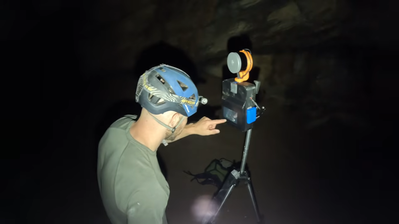
How do you measure the inside of a cave? You could do a bunch of hard work with classic surveying gear… or you could just use a laser scanner. [9nl] did the latter, with a scanning rig of his own creation.
The build is based around an Ouster VLP-16 mid-range lidar sensor. It shoots out pulses of light and measures how long it takes them to bounce back in order to determine the range of objects in the vicinity, and thus can be used to great effect for 3D scanning tasks. For [9nl], though, the sensor had a serious limitation. Since it only had a 40-degree field of view, it wasn’t ideal for the desired application of scanning a cave. However, by building a custom rig that could rotate the sensor, [9nl] ended up with a rig that could 3D scan an area through a full 360 degrees. There’s nothing wildly complex involved, just some good old mechanical engineering—putting the sensor on a shaft and spinning it with a belt drive. Then it’s just a matter of processing the data correctly. The hard part is then getting the rig in and out of the cave without breaking anything.
There are plenty of off-the-shelf 3D scanning solutions that can do this work, but few of them come cheap. Plus, rolling your own teaches you a great many things as you hone your solution to your particular needs. Video after the break.
[Thanks to Kovy Jacob for the tip!]


That is really cool!
next step: put it on an autonomous drone, as predicted in Prometheus https://www.youtube.com/watch?v=yO-eduvo904
But, ouch, the cost of that scanner.
Those suckers weight a lot more than they look too. Full of thick, heavy glass and precision-machined castings.
Can you come scan my property???
does it change regularly? If not some normal leasers (pointers), trigonometry and land surveyor equipment should be enough?
Like two laserpoints a fixed distance apart on a single contraption and both can be oriented very accurately (the angles can be read very accurately)?
For the life of me I can’t remember the name of this “ancient” device used by ship navigators to “pinpoint” stars/waypoints/etc – something something tangent?
That’s a sextant. But you really want a theodolite.
Brent Underwood from the YouTube channel Ghost Town Living, bought Cerro Gordo, an abandoned silver mine in California. He had a company come in and 3D scan the environment and parts of the mine. It’s absolutely not DIY, but very interesting as a comparison to this DIY approach.
https://poly.cam/cerro-gordo
The quality of this DIY method is very impressive. I wonder if it would be possible to combine this with an mbes style system to be able to actually go through the walls of the cave and look what’s inside the walls. Different rock layers, types of rocks and steel/gold/silver.
Maybe not MBES (hard to do without an intervening layer of water), but ground-penetrating radar would be a neat addition. It would be really complex to scan the antenna(s) over most of the surfaces, but maybe there’s a way.
This is absolutely lovely. I bet it would be really useful for interior designers, to get a decent CAD ready model of the house would really, really help to plan stuff and run ideas by with clients
This is already common in real estate sales. They don’t LiDAR, but instead use cell phone photos and plain old photogrammetry. Then they use AI to artificially stage the interior with better furniture and artwork. It’s quick and cheap, and sometimes some of them look remarkably good.