
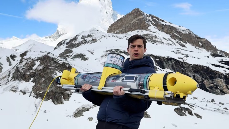
Doing anything on a frozen lake can carries some amount of risk. Nevertheless, every year events ranging from car racing to ice skating are held on them. As such, proper safety precautions are needed, the most important of which is ensuring the ice is thick enough to withstand the weight of whatever may be on it. This is done by cutting holes into the ice and measuring its depth in several locations. But this is a dangerous and imperfect process only giving a rough picture of actual thickness. So to solves these problems, a team of students at ETH Zurich made an ice measuring submersible drone.
The concept of ice measurement employed is, on paper, reasonably simple. When a sonar pulse is sent out, some of the energy will return off the bottom of the ice sheet, but some of it will pass through creating a second return. By measuring the difference in these two returns, the thickness can be calculate with a high degree of precision. Attach the sonar to a submersible and give it a positioning system and you can simply get a thickness map, right? Well, employing theory in practice is a far more complicated prospect as the students soon found out.
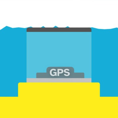 The submersible itself is slightly positively buoyant. It features two concrete ballasts to adjust the center of gravity and six propulsion motors for six degrees of freedom. It’s powered by a NVIDIA Jetson to allow for autonomous operations and a whole host of sensors. Navigation is handled by a variety of sensors, mostly GPS and SBL. The GPS antenna sits in a radome at the top of the submersible, allowing for a strong enough signal for a positional fix when touching the bottom of the ice. SBL works similarly to sonar, where a transmitter on the submarine sends out an audio ping, received by a trio of hydrophones used to calculate the drone’s position.
But does all this complexity really work? Well, mostly. A number of real-world factors greatly compound the submarine’s effectiveness. The signal noise from in the sonar makes accurate measurements nigh impossible with that methodology. As such, the team used a depth based approach, by touching the submarine to the bottom of the ice, and measuring the water pressure and therefore depth, the ice’s thickness can be easily calculated. However, this method too is not without flaws. When snow falls on alpine lakes, it pushes the ice sheet downward, and a new ice sheet can form on top. This top sheet’s layer is what’s most important, but the depth measurement can only take into account the overall sheet’s thickness. Regardless, this was a really impressive first test of the submersible, and we look forward to seeing where it goes from here!
Make sure to check out this autonomous submarine next!











Typo: “slightly positively botany”
That’s what they did to Brussels Sprouts to try to make people believe them things is food
I hope my dentist doesn’t read this: “two concrete ballasts to adjust the center of cavity”
Kirk Johnson (the man behind the Goatse) has two ballasts used to adjust the center of his cavity, but they are so hard that they had to be made out of stainless steel tungsten.
No ordinary man would stretch so wide.
And here I didn’t believe SLBMs could be shorter…must be accordions in there.
Ice thickness checks like this are the same problem boat skippers have before they commit to a day on the water. Ballast and center of mass matter more than the camera once you are actually moving.
Curious how they keep the tether from freezing into the hole after twenty minutes. That is usually what kills these backyard ice ROV jobs, not the camera. A short soak in warm water between dives would be boring but it works.
Wouldn’t it be possible to use the sonar idea, but from the top … I know its boring but maybe just an rc car shooting sound waves from the top to the bottom and measuring the thickness based on reflections?
Just run a nichrome wire through it. If power is coming from the base station, it shouldn’t be an issue to just permanently keep the tether above the freezing point of water.
And I was hoping it was meant up-the-shiny of some three-letter agency.
You can’t even create headlines containing the name of frozen water anymore.
Obsessed
GPS under ice and snow
Well, it’s using SBL too. So the GPS can fail and it will still know exactly where it is based on the SBL. There were navigation systems in cars before GPS that worked in a similar way, by measuring the amount of distance the car has driven. It was only a problem if you missed an exit.
i think ‘compound’ should have been ‘confound’ ?
i’m disappointed the sonar didn’t work…that sounds like a neat way to measure ice. trying to use GPS under the ice seems implausible to me, and overall the project seems too complicated…i feel like it’d be easy for the sub to get trapped.
wouldn’t it be easier to have a car that goes on top of the ice? same sonar trick to mesure thickness. doesn’t seem like it would be hard to have an actuator to lower the sonar module to be in physical contact with the top of the ice. might allow the field conditions to be closer to the lab conditions? you could even drag your oscope and laptop out on the ice for experimentation…
The hard part under ice is not the vehicle, it is knowing where it is. Acoustic positioning gets awkward when the surface you would normally reference is a moving lid, and dead reckoning drifts faster than people expect in cold water. Anything that comes back on its own has solved that first.