Arduino Data Logger Maps Out The Potholes On Your Morning Commute

Now you can prove that you have the bumpiest commute in the office by measuring how rough your ride actually is. [Techbitar] calls the project the Bump-O-Meter. It uses an Arduino, GPS, and accelerometer to map out rough roads.

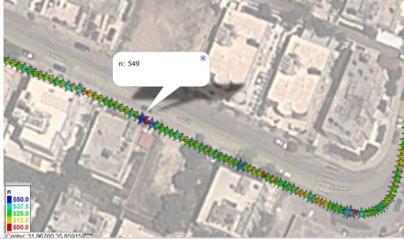
The hardware was built on a breadboard and [Techbitar] goes into detail about connecting and communicating with each module used. Once it’s running, the logger will read up to six sensors and record them to an SD card. In the video after the break he shows the method used to dump and graph the data. He starts by looking at the data in a spreadsheet. There are many fields included in the file but only three of them are needed to graph what is seen above. After narrowing down the number of columns he heads over to GPS Visualizer and uploads the data set which is then automatically plotted on the map.

In a Utopian society all city owned vehicles would have a system like this and the bad sections of road would automatically appear on the road crew’s repair list.

Continue reading “Arduino Data Logger Maps Out The Potholes On Your Morning Commute”

Stacking GPS, GSM, And An SD Card Into An Arduino Shield

A few years ago, [Phang Moh] and his compatriots were asked by a client if they could make a vehicle tracking device for oil tankers all around Indonesia. The request of putting thousands of trackers on tanks of explosives was a little beyond [Phang Moh]’s capability, but he did start tinkering around with GPS and GSM on an Arduino.

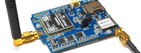
Now that tinkering has finally come to fruition with [Phang]’s TraLog shield, a single Arduino shield that combines GPS tracking with a GSM and GPRS transceiver. There’s also an SD card thrown in for good measure, making this one of the best tracking and data logging shields for the Arduino.

The shield can be configured to send GPS and sensor data from devices attached to an I2C bus to remote servers, or a really cool COSM server. [Phang] is selling his TraLog for $150, a fairly good deal if you consider what this thing can do.

Seems like the perfect piece of kit for just about any tracking project, whether you want to know the location of thousands of oil tankers or just a single high altitude balloon.

Tip ‘o the hat to [Brett] for finding this one.

Spoofing GPS And Getting Your Own UAV

A couple folks over at the Radionavigation Lab at UT Austin successfully spoofed GPS to take control of a small helicopter drone this weekend. Of course, this attracted the attention of the Department of Homeland security, so you’d better stock up on GPS spoofing equipment while there’s still time.

The DHS, CIA, and US Military have a huge interest in spoofing GPS; Iran stole a drone late last year using the same method. The UT Austin team used only about $1000 worth of equipment to take control of an autonomous drone and pilot it away under unauthorized control. Of course with matters of homeland security, the open-source hacker scene has yet to publish how this spoofing attack was actually done, but here’s a paper covering what is needed to remotely control up to four GPS-guided drones.

While waiting on the details of this build to be made public, feel free add your own insight in the comments as to how this attack was actually performed.

How Do Atomic Clocks Work?

[Bill Hammack] aka [Engineerguy] is back again with another fantastic informational video. This time around he’s describing exactly how an atomic clock does what it does. He starts off with a great analogy of jello jiggling when poked. He explains how this is similar to the quartz crystal inside the clock oscillating due to the electrical “poke” we give it.  He goes on to explain how GPS satellites rely on this accuracy when determining physical locations on the ground.

As usual, [Bill] does a fantastic job of delivering the information quickly and packed full of detail, while still keeping it simple enough that even those unfamiliar with the technology can follow along.

Continue reading “How Do Atomic Clocks Work?”

Building A DIY GPS Cube

Originally, [Karman] wanted to build a speedometer for his bike. Feature creep makes fools of us all, so after a month of work [Karman] had a  GPS-enabled cube that tells him his current latitude and longitude, current time, course, direction and speed.

[Karman]’s GPS cube uses a cheap GPS module, Arduino Mini Pro, a magnificent OLED display, and a LiPo battery salvaged from a first gen iPod nano. Surprisingly, the build is very clean – there are no wires, headers, or random epoxy globs sticking out everywhere. The entire build is just a bit larger than one cubic inch, allowing [Karman] to carry around the power of a GPS device in his pocket.

The code for [Karman]’s GPS cube uses the TinyGPS library for Arduino, that has a few great functions that track the number of satellites visible and report the current time. Now all that’s left to do is fabricate a case for this awesome little project. As always, video demo after the break.

Continue reading “Building A DIY GPS Cube”

Those USB TV Tuners Used For SDR Can Also Grab GPS Data

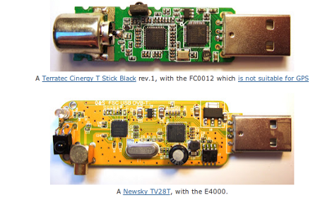
Talk about versatile hardware. These inexpensive TV tuner dongles can also grab GPS data. You may remember seeing this same hardware used as a $20 option for software defined radio. But [Michele Bavaro] decided to see what other tricks they could pull off.

Would it surprise you that he can get location data accurate to about 20 centimeters? That figure doesn’t tell the whole story, as readings were taken while the dongle was stationary for three hours, then averaged to achieve that type of accuracy. But depending on what you need the data for this might not be a problem. And [Michele] does plan to implement real-time GPS data in his next iteration of the project. He plans to use an SDR acquisition algorithm to measure doppler shift in accounting for the slow clock speed of the dongles compared to standard GPS receivers. We can understand how that would work, but we’re glad he has the skills to actually make it happen because we’re at a loss on how the concept could be implemented.

[via Reddit]

Using GPS To Stay Aware Of Red Light Cameras

red-light-camera-alerter

Depending on how you view them, red light cameras are a great way to get people to drive carefully, or an utter nuisance. We agree with the latter opinion, as does [Dave], so he built a handy little device that alerts him when he’s about to approach one of these intersections.

His Red Light Camera Alerter is based around an Atmega 328P sporting the Arduino bootloader. The micro obtains GPS coordinates while [Dave] is driving, comparing his current location with a table of all known red light intersections in the area. As he nears a red light camera, the status LED changes colors from blue to yellow to red as he gets closer, making it easy to keep aware of his situation. He also included an Adafruit OLED display in his device, which relays his speed, GPS coordinates, heading, and actual distance from the red light in real time.

While [Dave] admits that he doesn’t really have a need for the alerter as there are only a couple located in his immediate vicinity, he says it was a fun and easy way to get some experience with using GPS sensors in his projects. He doesn’t have any video of it in action, but you can find the code he uses to drive the alerter on his blog.