Simulating UAVs In Unreal Engine

When it comes to building real-world flying vehicles, testing can be arduous and expensive. You have to find somewhere to fly, then you have to contend with environmental conditions and the possibility of damaging your craft if things go wrong. Simulation is a great solution to this, allowing testing without so much risk. To that end, [AlexanderRex] whipped up a platform for testing UAVs from the comfort of your computer desk.

PteroSim is intended as a comprehensive test bench for simulating autonomous aerial vehicles. It can run PX4, ArduPilot, and Betaflight binaries right in the simulator. The autopilot code is given simulated sensor data, and in turn responds with actuator commands, just as it would in a real craft. The simulator runs the flight dynamics using JSBSim, and the resulting scene is rendered in Unreal Engine 5.

If you’ve ever wanted to quickly road test different autopilot settings without heading out to the field or risking hardware, this is a great way to do so. It’s hard to beat the speed of iteration that is possible when testing on the computer on your desk. We’ve featured similar work before, too.

Continue reading “Simulating UAVs In Unreal Engine”

Hackaday Links Column Banner

Hackaday Links: October 19, 2025

After a quiet week in the news cycle, surveillance concern Flock jumped right back in with both feet, announcing a strategic partnership with Amazon’s Ring to integrate that company’s network of doorbell cameras into one all-seeing digital panopticon. Previously, we’d covered both Flock’s “UAVs as a service” model for combating retail theft from above, as well as the somewhat grassroots effort to fight back at the company’s wide-ranging network of license plate reader cameras. The Ring deal is not quite as “in your face” as drones chasing shoplifters, but it’s perhaps a bit more alarming, as it gives U.S. law enforcement agencies easy access to the Ring Community Request program directly through the Flock software that they (probably) already use.

Continue reading “Hackaday Links: October 19, 2025”

Hackaday Links Column Banner

Hackaday Links: September 28, 2025

In today’s “News from the Dystopia” segment, we have a story about fighting retail theft with drones. It centers on Flock Safety, a company that provides surveillance technologies, including UAVs, license plate readers, and gunshot location systems, to law enforcement agencies. Their flagship Aerodome product is a rooftop-mounted dock for a UAV that gets dispatched to a call for service and acts as an eye-in-the-sky until units can arrive on scene. Neat idea and all, and while we can see the utility of such a system in a first responder situation, the company is starting to market a similar system to retailers and other private sector industries as a way to contain costs. The retail use case, which the story stresses has not been deployed yet, would be to launch a drone upon a store’s Asset Protection team noticing someone shoplifting. Flock would then remotely pilot the drone, following the alleged thief back to their lair or hideout and coordinating with law enforcement, who then sweep in to make an arrest.

Continue reading “Hackaday Links: September 28, 2025”

Power Line Patrols: The Grid’s Eye In The Sky

Those of us who like to monitor air traffic with ADS-B aggregators such as FlightAware and ADS-B Exchange tend to see some interesting flight paths. I’m not talking about the truly ambitious pictures drawn by pilots, or even the more ribald ones, but rather flights that follow paths that seem to make little sense from either a commercial or leisure standpoint.

Most of these mystery flights have long straight stretches interrupted by occasional tight loops, and often cover great distances across rural and urban landscapes alike. A glance at the ADS-B data indicates that these flights are usually pretty close to the ground, and are often completed by helicopters. Occasionally, the registration of the aircraft will even indicate ownership by some “three-letter” federal agency.

Although mystery helicopters flying odd patterns in the sky seems like a good excuse to don a tinfoil hat and head to one’s bunker, chances are pretty good that these aircraft are engaged in a far less nefarious and far more useful endeavour: aerial transmission line patrols. These flights are key to keeping the transmission lines that form the backbone of the grid in tip-top shape, especially at a time of unprecedented growth in load and a shift in the generation profile away from fossil fuels towards renewables.

Continue reading “Power Line Patrols: The Grid’s Eye In The Sky”

Budget-Minded Synthetic Aperture Radar Takes To The Skies

Unless you work for the government or a large corporation, constrained designs are a fact of life. No matter what you’re building, there’s likely going to be a limit to the time, money, space, or materials you can work with. That’s good news, though, because constrained projects tend to be interesting projects, like this airborne polarimetric synthetic aperture radar.

If none of those terms make much sense to you, don’t worry too much. As [Henrik Forstén] explains, synthetic aperture radar is just a way to make a small radar antenna appear to be much larger, increasing its angular resolution. This is accomplished by moving the antenna across a relatively static target and doing some math to correlate the returned signal with the antenna position. We saw this with his earlier bicycle-mounted SAR.

For this project, [Henrik] shrunk the SAR set down small enough for a low-cost drone to carry. The build log is long and richly detailed and could serve as a design guide for practical radar construction. Component selection was critical, since [Henrik] wanted to use low-cost, easily available parts wherever possible. Still, there are some pretty fancy parts here, with a Zynq 7020 FPGA and a boatload of memory on the digital side of the custom PCB, and a host of specialized parts on the RF side.

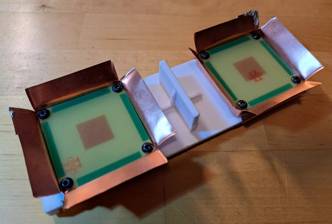
The antennas are pretty cool, too; they’re stacked patch antennas made from standard FR4 PCBs, with barn-door feed horns fashioned from copper sheeting and slots positioned 90 to each other to provide switched horizontal and vertical polarization on both the receive and transmit sides. There are also a ton of details about how the radar set is integrated into the flight controller of the drone, as well as an interesting discussion on the autofocusing algorithm used to make up for the less-than-perfect positional accuracy of the system.

The resulting images are remarkably detailed, and almost appear to be visible light images thanks to the obvious shadows cast by large objects like trees and buildings. We’re especially taken by mapping all combinations of transmit and receive polarizations into a single RGB image; the result is ethereal.

Hackaday Links Column Banner

Hackaday Links: January 26, 2025

Disappointing news this week for those longing for same-hour Amazon delivery as the retail giant tapped the brakes on its Prime Air drone deliveries. The pause is partially blamed on a December incident at the company’s Pendleton, Oregon test facility, where two MK30 delivery drones collided in midair during light rain conditions. A Bloomberg report states that the crash, which resulted in one of the drones catching fire on the ground, was due to a software error related to the weather. As a result, they decided to ground their entire fleet, which provides 60-minute delivery to test markets in Arizona and Texas, until a software update can be issued.

Continue reading “Hackaday Links: January 26, 2025”

Dog Poop Drone Cleans Up The Yard So You Don’t Have To

Sometimes you instantly know who’s behind a project from the subject matter alone. So when we saw this “aerial dog poop removal system” show up in the tips line, we knew it had to be the work of [Caleb Olson].

If you’re unfamiliar with [Caleb]’s oeuvre, let us refresh your memory. [Caleb] has been on a bit of a dog poop journey, starting with a machine-learning system that analyzed security camera footage to detect when the adorable [Twinkie] dropped a deuce in the yard. Not content with just knowing when a poop event has occurred, he automated the task of locating the packages with a poop-pointing robot laser. Removal of the poop remained a manual task, one which [Caleb] was keen to outsource, hence the current work.

The video below, from a lightning talk at a conference, is pretty much all we have to go on, and the quality is a bit potato-esque. And while [Caleb]’s PoopCopter is clearly still a prototype, it’s easy to get the gist. Combining data from the previous poop-adjacent efforts, [Caleb] has built a quadcopter that can (or will, someday) be guided to the approximate location of the offending package, home in on it using a downward-looking camera, and autonomously whisk it away.

The retrieval mechanism is the high point for us; rather than a complicated, servo-laden “sky scoop” or something similar, the drone has a bell-shaped container on its belly with a series of geared leaves on the open end. The leaves are open when the drone descends onto the payload, and then close as the drone does a quick rotation around the yaw axis. And, as [Caleb] gleefully notes, the leaves can also open in midair with a high-torque yaw move in the opposite direction; the potential for neighborly hijinx is staggering.

All jokes and puns aside, this looks fantastic, and we can’t wait for more information and a better video. And lest you think [Caleb] only works on “Number Two” problems, never fear — he’s also put considerable work into automating his offspring and taking the awkwardness out of social interactions.

Continue reading “Dog Poop Drone Cleans Up The Yard So You Don’t Have To”