Bathymetric Map Uses Edge Lighting To Stunning Effect

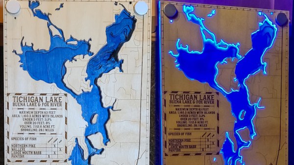
A bathymetric map is one concerning the floor or bottom of a body of water. It’s the wet equivalent of a topographical map. Combine this with humanity’s inherent taste in seaside real estate, and they can be quite attractive when done correctly. We’d say this effort from [pubultrastar] hits the mark.

Created as a commission piece, the subject of the map is Tichigan Lake in Wisconsin, USA. Made on a Glowforge laser cutter, the design is built of layers of lasercut wood stacked up to represent the natural contours of the bottom of the lake. There’s also a layer of acrylic included, to which special standoffs are fitted. These standoffs hide blue LEDs inside, which allow the acrylic to be edge lit without the LEDs themselves being visible.

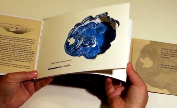
The final effect is impressive, with the blue water contrasting artfully with the laser-engraved wood front panel when the lights are turned on. It’s an excellent conversation piece, particularly for those with a waterfaring bent. It’s not the first bathymetric map we’ve featured, either, with this book serving as a particularly stunning example.

Laser Cutting Bathymetric Maps

Bathymetry is the underwater equivalent to topography. And with the right map data, you can make some amazing 3D laser cut maps that feature both land masses — and the details under the sea. [Logan] just learned how to do this, and is sharing his knowledge with us.

[Logan] holds the typical hacker belief: The best way to learn something is just to start the project and figure it out as you go. Which also makes him an excellent candidate for helping others to learn what not to do. His goal of the project was to create a visually stunning map of Vancouver that helps to emphasize the depth of the ocean just off the coast.

To do this he obtained bathymetry data from the Fisheries and Oceans of Canada, and city map data from Open Street Map, a service we’re very familiar with that has provided data for many cool hacks, like this Runner’s GPS unit. The tricky part now is combining the data in order to laser it.

Continue reading “Laser Cutting Bathymetric Maps”

Making A Bathymetric Book By Hand And Searching For An Easier Way

We first saw this Bathymetric Book at our local hackerspace, Sector67, quite some time ago. [Caroline Rose] gave a seven minute presentation on the project as part of the monthly meeting which is open to the public. You can get a pretty good feel for the book that includes a to-scale depth representation of Crater Lake in the introductory post which she recently published. Each page makes up one topographical ring of the lake. Put them all together and you’ve got a really amazing way to explore the watery depths of the deepest lake in the United States.

The book you see above is hand made. She downloaded the depth data from the US Geological Survey, then put it through some processing in order to print one elevation level on each page. That’s when the work really began. She cut out every page by hand! The four-plus hour task was grueling. And just for a bit of added punishment she even made a second book. But at Tuesday night’s follow-up presentation she said never again.

[Caroline] developed a much faster and still accurate technique for producing the bound-book depth maps. She is using a laser cutter and a different binding technique. By using folded packets of paper, rather than individual pages, she is able to cut out three double-sheets at once — including holes for the binding thread and the outline of the finished pages themselves. This cuts the process down to about four minutes of laser cutter time.

For now you’ll have to settle for a time-lapse video of the hand-cutting process (embedded below). But we hope to post an update when she makes more information about the laser-cut version available.

Continue reading “Making A Bathymetric Book By Hand And Searching For An Easier Way”