PCBs are traditionally designed with traces laid out to support a circuit full of electronic components. However, they’ve become increasingly popular as a way to produce functional visual artworks. This PCB map from [Jonathan] is a great example.
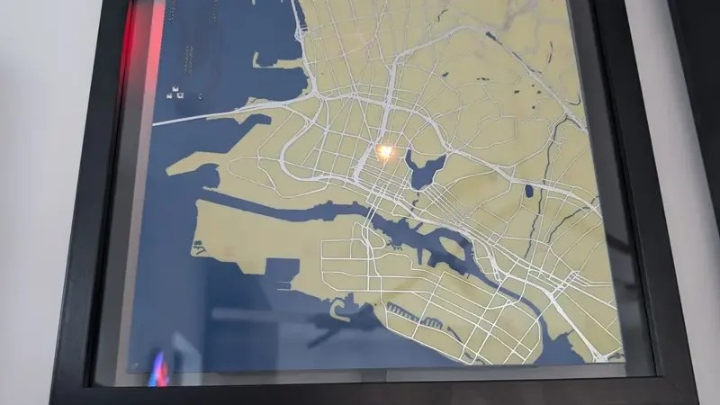
The PCB was designed as a map of the California East Bay area. The roads are laid out as the top-side copper layer, while the land and roads are used for the top solder mask layer, with the flipped land and roads area making up the solder mask on the bottom side. The map data itself was cribbed from Snazzy Maps. Behind the PCB, [Jonathan] mounted a 64 x 32 RGB LED array, which can be seen glowing through from behind the material. The LEDs are controlled by an ESP32, which grabs location data from [Jonathan’s] family member’s mobile devices over MQTT, and uses it to light their positions on the map. Files are on Github for the curious.
If you’ve got a family that is open to location tracking, and the money to pay for a custom PCB, you could probably recreate this project yourself. We’ve seen some other great PCB maps before, too, like this amazing metro tracker. Video after the break.


this is genuinely unhinged and disturbing.
Why? People have been (ab-)using PCB manufacturing to create functional or decorative panels for quite some time, and the manufacturers don’t seem to mind.
The stalking your family part?
I like that you thought the “unhinged and disturbing” comment was aimed at the PCB part of this project.
What else is supposed to be “unhinged and disturbing” here? The tracking, relying entirely on Google Maps’ built-in location sharing which has to be consciously enabled? I find it hard to white-knuckle pearls over an opt-in feature.
For real! It’s not strange for a bunch of people who have to coordinate to want to know each others’ location.
We use this feature with my son — sixth grader, he wants it on and knows it’s on. It lets us know which bus he’s on, which makes lunch preparation easier to time, for instance.
It would be creepy if you were tracking people who didn’t know or want to be tracked. That’s for sure. We have no indication that’s the scenario here, though, right?
This is pretty standard for families these days. All families I know have all their locations shared on a map app of some sort. Not sure why people think this is stalking when it’s just close family.
It is somewhat unhinged/disturbing if you use a big tech firm for tracking at least.
Especially when tracking kids.
An inability to see why does not exactly help.
Is it even legal?
When you’re a star, they let you do it.
Yep, stalker territory.
Why? It quite clearly says Family members that are open to location tracking. Most people I know share their location with their immediate family these days. I don’t think stalking is the correct term here personally.
Family members that are open to it.
Indoctrination.
Emotional abuse.
Threats of physical abuse.
Grooming.
All of these are the not so nice reasons for people to “agree”.
Parents wanting to know where their children are is not some fringe sinister concept. “Call me when you get there” is hardly a recent invention, family location sharing is just the digital version of the same idea.
If you want to argue that this can become abusive, sure, there’s a discussion to be had about that. But jumping straight to extreme abuse rhetoric, and especially dragging “grooming” into the discussion, says far less about the project than it does about your apparent need to be morally outraged.
Hi, the project’s creator here. The location data comes from Google’s built-in location sharing feature, which is opt-in, gives periodic reminders while enabled, and is easy to turn off. The PCB map itself hangs in a shared space and, given its relatively low resolution and low update rate, is far less useful for stalking someone than simply opening Google Maps on a phone.
That said, I completely understand the reaction. We’ve largely normalized being tracked digitally, but there’s something more visceral about seeing that tracking represented physically in the real world instead of abstractly existing on a server somewhere.
There might be something to using the same hardware at a gallery as a performance art piece. Where it displays WiFi based tracking that some shopping centers use to track customer shopping habits.
Map of the Bay area. Yeah.
Yeah, right, PCB manufacturers in China think it’s pretty normal that your every move gets tracked.
Other than the ethics of location tracking family… PCB looks ok but I feel the LEDs are too low-resolution (or maybe just spaced too far apart) and not very bright, also looks like a lot of light bleed
“The roads are laid out as the top-side copper layer, while the land and roads are used for the top solder mask layer, with the flipped land and roads area making up the solder mask on the bottom side.”
Did anybody else find that segment confusing AF? So the roads are top-side copper, top solder mask layer, and the solder mask on the bottom side?
Yeah, that made no sense, and I went to the project page partly to clear it up. (The project’s own blog page was pretty good, and the videos embedded here are not remotely a substitute.)
Front: solder mask for water, copper for roads, bare PCB for other land.
Back: He wanted the LEDs (from a separate panel) to shine through, so he removed the copper and solder mask from the “land” and kept his own components underwater.
I’m more interested to know how is he gathering that data through matt.
Also I’m a bit tired of the stupid comments about “stalking”.