Science Officer…Scan For Elephants!

If you watch many espionage or terrorism movies set in the present day, there’s usually a scene where some government employee enhances a satellite image to show a clear picture of the main villain’s face. Do modern spy satellites have that kind of resolution? We don’t know, and if we did we couldn’t tell you anyway. But we do know that even with unclassified resolution, scientists are using satellite imagery and machine learning to count things like elephant populations.

When you think about it, it is a hard problem to count wildlife populations in their habitat. First, if you go in person you disturb the target animals. Even a drone is probably going to upset timid wildlife. Then there is the problem with trying to cover a large area and figuring out if the elephant you see today is the same one as one you saw yesterday. If you guess wrong you will either undercount or overcount.

The Oxford scientists counting elephants used the Worldview-3 satellite. It collects up to 680,000 square kilometers every day. You aren’t disturbing any of the observed creatures, and since each shot covers a huge swath of territory, your problem of double counting all but vanishes.

Continue reading “Science Officer…Scan For Elephants!”

Open Source Intel Helps Reveal US Spy Sat Capabilities

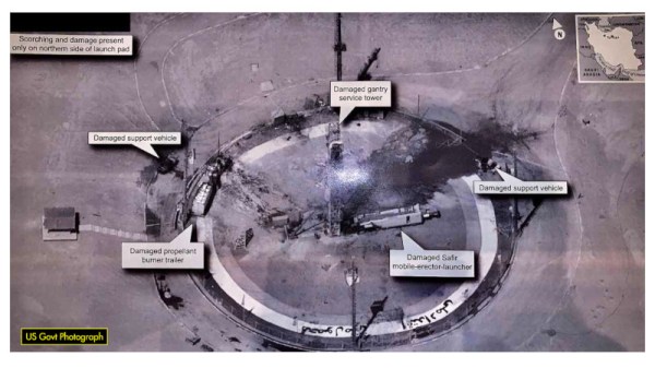
On the 30th August 2019, the President of the United States tweeted an image of an Iranian spaceport, making note of the recent failed Safir launch at the site. The release of such an image prompted raised eyebrows, given the high resolution of the image, and that it appeared to be a smartphone photo taken of a classified intelligence document.

Inquisitive minds quickly leapt on the photo, seeking to determine the source of the image. While some speculated that it may have been taken from a surveillance aircraft or drone, analysis by the satellite tracking community disagreed.

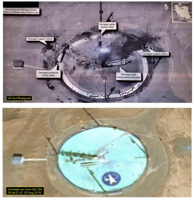
A comparison of the actual image, top, and a simulation of what a shot from USA 224 would look like. Ignore the shadows, which are from an image taken at a different time of day. Note the very similar orientation of the features of the launchpad.

The angle of shadows in the image was used to determine the approximate time that the image was taken. Additionally, through careful comparison with existing satellite images from Google Maps, it was possible to infer the azimuth and elevation of the camera. Positions of military satellites aren’t made public, but amateur tracking networks had data placing satellite USA 224 at a similar azimuth and elevation around the time the image was taken.

With both the timing and positioning pointing to USA 224, evidence seems conclusive that this KH-11 satellite was responsible for taking the image. The last confirmed public leak of a Keyhole surveillance image was in 1984, making this an especially rare occurrence. Such leaks are often frowned upon in the intelligence community, as nation states prefer to keep surveillance capabilities close to their chest. The Safir images suggest that USA 224 has a resolution of 10cm per pixel or better – information that could prove useful to other intelligence organisations.

It’s not the first time we’ve covered formerly classified information, either – this teardown of a Soviet missile seeker bore many secrets.