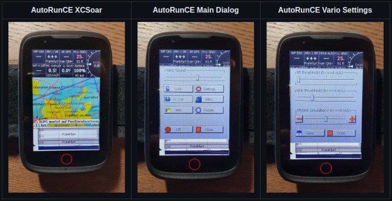
Flying a glider, or similarly piloting a paraglider or hang glider, can all be pathways into aviation with a lower barrier of entry than powered flight. Sacrificing one’s engine does generate a few complexities, but can be rewarding as the pilot searches for various means of increasing altitude like ridge soaring or thermaling. You’ll need a special instrument called a variometer to know just how much altitude you’re gaining though, like this one which is built into commercially-available handheld GPS units.
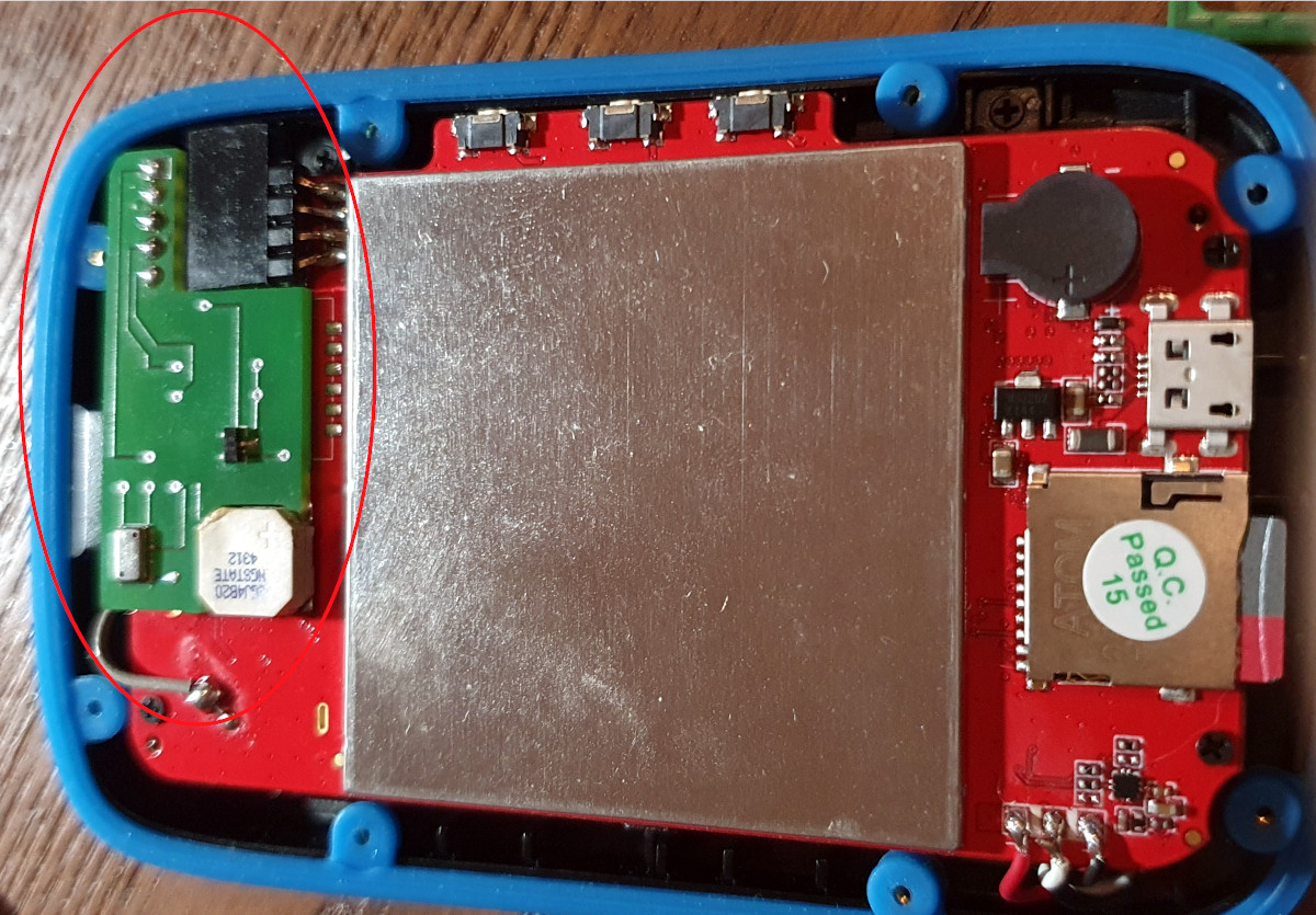 These GPS units are normally intended for use on terra firma only, but [Oganisyan] has figured out a clever way to add this flight instrumentation to these units to help when operating a paraglider. An ATmega328 paired with a pressure sensor is added to the inside of the GPS units and communicates with an available serial interface within the units. To complete the modification, a patched firmware must be installed which adds the variometer function to the display. This upgrade is compatible with a handful of GPS units as well such as the BikePilot2+ or Falk Tiger.
For those who already own one of these GPS units, this could be a cost-effective way of obtaining a variometer, especially since commercially-available variometers tailored for this sort of application can cost around $200 to $500. It is an activity sensitive to cost, though, as it offers a much more affordable option for taking to the skies than any powered craft could, with an exception made for this powered paraglider which offers the ability for powered take off and flight extension using electric-powered props.
Thanks to [MartinO] for the tip!


This is a nice idea but you should be very confident in your engineering skills and engenering skills of the firmware developper to use this device. Usually, flight instruments are extensively tested and often use redundency. If someone want to use this device, every failure mode should be considered and back up plans should be identified before take of.
Eh, its not that big of a deal, gliding is not as strict as powered flight for instruments. I have flown many times without any instruments. They are really used just so you can have a quick indication of lift or sink. I mean, by all means, test it. But if it fails you just keep going and maybe miss some really light lift here and there. You should always be within glide of a landing site, which for a glider is usually any area without trees thats 15×30 m. If you land out, pack up, carry to a road and call your buddies.
This device has GPS-data.
Why ist there a need for an additional pressure Sensor?
GPS is great for 2D positioning, it isn’t quite as great for the third dimension.
I believe some of the other newer GPS systems are better in the up-down direction though IIRC.
Varios typically implement a sound based alert to rise and sink rates and are extremely sensitive. As in they can be triggered based on moving your hand up and down, so it’s not something that can be accomplished by just looking at your GPS elevation occasionally.
The vario’s I’ve used in sailplanes generally come in two varieties: those that are rigged to the pitot/static system and do not require any electricity whatsoever, and then electronic ones that beep according to rise or sink; they also tend to be “energy compensated variometers” which means they integrate (If I remember right) airspeed and altitude (kinetic and potential energy) so that you don’t see as many “stick thermals” where you pull the stick back and gain altitude and all of a sudden you are “climbing.” Total energy management is the fun part of flying gliders. BTW the beeping is so that you don’t have to look in the cockpit as much and can keep looking out the canopy instead.
Paragliders, on the other hand, have both functionalities in the same device and do without energy compensation.
So how does the pressure sensor resolve barometric pressure variations that accompany different weather patterns like low pressure storm fronts? Or am I not thinkin of atmospheric pressure the right way relaying to altitude? I thought that was an issue with things like rescue helicopters where traveling too high in mountain areas can be dangerous if you encounter a weather front pattern you could suddenly lose air density reducing lift on the blades and it’ll drop you into a dive u can’t recover from and smack into the side of a mountain? Would gliders or planes be vulnerable to the same issue? And wouldn’t that cause a potential miscalculation from the pressure sensor giving u an incorrect altitude reading?
In powered planes, you use a known elevation (surveyed field elevation) to set the barometric altimeter when you take off, to accommodate for weather changes. People run into issues, sometimes literally, when the pressure changes between takeoff and landing, but in general there are services that’ll tell you the barometric pressure at the nearest ground station to your position.
And yeah, there’s true altitude, the height above sea level, pressure altitude, which is what you calibate the altimeter with when you’ve set the true altitude adjusted for atmospheric pressure under standard conditions, and density altitude, which is what you actually measure on your altimeter, that’s a function of temperature, altitude, and barometric pressure. What you see on the altimeter is density altitude and you have to correct either the altimeter or keep in mind the correction factor for the current conditions to find your true altitude.
There are published adjustment settings across a very wide range of temperature and altitude conditions. An interesting corollary to this is that for a few airports, Sky Harbor in Phoenix comes to mind, there are a non-zero number of times when the physical conditions at the airport exceed published specifications so commercial flight is prohibited because they don’t have accurate calibration data.
Wow I had no idea that u had to set everything up like that everytime you fly. It makes perfect sense now that you explained how it’s done and there’s a whole system with ground stations in place It seems like a pretty intuitive common sense support infrastructure. I’m terribly fearful of flying I hate getting on planes. I guess it never occurred to me that there was that much that went into keeping track of altitude. Now I feel like being a pilot is a pretty undervalued (underpaid too) skillset considering all the stuff you need to know about in addition to being able to take off fly and land without crashing.
And just a side tangent I’ll now add the complexities of maintaining accurate track of altitude to my growing list of dozens of reasons why flying cars are a pipedream that will never manifest itself for the public to realize and enjoy. Were still struggling to maintain, navigate, and expand our public transport infrastructure on the xy axis, add z to the mix and multiply all of the rules and safety concerns in 3d space and private sky vehicles zipping everywhere, it’s not something that will ever be regulated. It kinda blows mind that we’re even able to regulate the current space of commercial and private flight as the system is today.
Anyways thanks, appreciate the clear helpful explanation. 👍