Communicating From Anywhere With A SPOT Connect

[Nate] over at Sparkfun put up a great tutorial for using the SPOT personal satellite communicator with just about any microcontroller. These personal satellite transmitters were originally intended to pair with the bluetooth module of a smart phone, allowing you to send a short 41-character message from anywhere in the world. Now, you can use these neat little boxes for getting data from remote sensors, or even telemetry from a weather balloon.

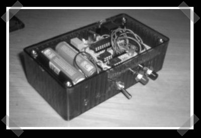
[Nate]’s teardown expands on [natrium42/a>] and [Travis Goodspeed]’s efforts in reverse-engineering the SPOT satellite communicator. The hardware works with the Globalstar satellite constellation only for uplink use. That is, you can’t send stuff to a remote device with a SPOT. After poking around the circuitry of the original, first-edition SPOT, [Nate] pulled out a much cheaper SPOT Connect from his bag of tricks. Like the previous hacks, tying into the bluetooth TX/RX lines granted [Nate] full access to broadcast anything he wants to a satellite sitting in orbit.

We’ve seen the SPOT satellite messaging service put to use in a high altitude balloon over the wilds of northern California where it proved to be a very reliable, if expensive, means of data collection. Sometimes, though, XBees and terrestrial radio just aren’t good enough, and you need a satellite solution.

The SPOT satellite service has an enormous coverage area, seen in the title pic of this post. The only major landmasses not covered are eastern and southern Africa, India, and the southern tip of South America. If anyone out there wants to build a transatlantic UAV, SPOT, and [Nate]’s awesome tutorial, are the tools to use.

Tip ‘o the hat to [MS3FGX] for sending this one in.

Pictures From Space For $150

prelaunch

Ever wanted to be able to launch a balloon into space, track its location via GPS, take some photographs of the curvature of the earth, and recover the balloon, all for the low low cost of $150? [Oliver Yeh] sent in his teams project, Icarus, which does just that. The group of MIT students found that they could use a weather balloon filled with helium to reach heights of around 20 miles above the earth;  their particular balloon achieved 93,000 feet (17.5 miles). Then, utilizing only off the shelf components with no soldering, conjured up a GPS tracker using a Motorola i290 Prepaid Cellphone. They then used a Canon A470 loaded with the chdk open source firmware to take pictures. After seeing the results of their launch, the team hopes that this could rejuvenate interests in science and the arts.

Simple GPS Data Logger


[Stefan] sent in this data logger that was built for a weather balloon project. It’s a very clean design that logs to a 64KB eeprom, can transmit its location via SMS through a cell phone and trigger a camera based on position if needed. The site has a tarball will full schematics and source – mod away.

Using Radiosondes As Cheap GPS Trackers

radiosonde

A Radiosonde is an inexpensive sensor package that’s intended to be used with a weather balloon for atmospheric measurements. The device transmits data in the 403 MHz band after being launched and they usually aren’t recovered after use. You can pick them up for very little money on eBay so [Nick] thought they might work well as a low cost GPS tracker. Unfortunately the Radiosonde doesn’t transmit standard NMEA GPS data, but GPS doppler measurements. It’s hard to determine what those are actually useful for. Nick did find one other paper documenting an unsuccessful attempt which he has posted to his site. So now Nick is looking for some help either making the data more useful or coming up with a functional device that’s just as inexpensive. Anyone got any leads?

Continue reading “Using Radiosondes As Cheap GPS Trackers”

High Altitude Linux Take 2

high altitude

[jcoxon] was inspired by the original Linux weather balloon project. His Pegasus 1 reached an altitude of 66,585ft and took over 600 pictures. The flight logging system is based on the Gumstix waysmall computer system. It captures data from the GPS receiver and controls two cameras. There are photos from both a downward facing camera and a side facing camera. Periodically the last three GPS entries are sent to Jame’s cellphone via SMS; this made recovering the payload a lot easier. There is already a second baloon planned.

Continue reading “High Altitude Linux Take 2”

Hackaday Links

hackaday links test 2

weather balloons for sale on ebay
360 degree views of the apollo missions
google maps!
beautiful and unique snowflakes
lock picking championship of the world
the definitive mit lockpicking guide
or, heck, safe cracking for computer scientists
hacking the no-fly list
disabling gps network to foil terrorists and probably aid workers
why couldn’t i instant message all day? answer: we ain’t tellin’
meatbops: britain licencing human cloning
searching for bobby phisher
robo scratch dj
mac mini recording studio howto
whoah, another monocycle.  kaneda must be so jealous.  well, maybe not.
mac mini server
looking forward to seeing this
google 302 pagejacking

Continue reading “Hackaday Links”