Aftermarket Visor-mounted GPS Better Than OEM

mini_gps

When [Roberto] bought his Mini Cooper, he opted to forgo the factory GPS system as it was over priced and didn’t have the best of reputations. He decided that he still needed GPS in his car, so he committed himself to install a TomTom unit in a way that would not detract from the car’s interior.

He dismantled the driver’s side sun visor, taking measurements of the original plastic housing that contained the mirror and lighting. He then drew up a 3D model of a replacement housing that would allow him to fit both the GPS unit and the speaker in the same amount of space formerly occupied by the mirror.

He gutted his TomTom unit, removing any extraneous parts he could find. A smaller speaker was sourced due to size constraints, then everything was mounted in his new housing once it arrived.

The end result is amazing. The GPS unit looks like it was installed at the factory – there is no sign that this was any sort of aftermarket modification. We are sure people will be quick to say that would be difficult to keep your eyes on the road while looking at the navigation screen, but as [Roberto] points out, you should be following the spoken directions once the car is in motion anyhow.

GPS-enabled Bag Allows For Carefree City Roaming

mapbag_lilypad

[Josh] was looking for a way to enjoy exploring the city of Chicago safely, and hacked together a messenger bag navigation system to ensure he always knew where he was going.

While riding, he wanted to embrace the idea of Dérive, but he felt that he was being too overly conscious of time as well as his location, which took all the fun out of his unplanned excursions. Having recently been “doored” by a car, he was also looking for a way to help him navigate the city streets without being overly distracted with finding his way around.

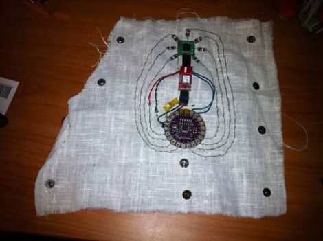
His “Map Bag” solves both of these problems for him, without being obtrusive. He fit a messenger bag with a LilyPad Arduino and a GPS receiver for keeping track of his location. The Arduino can constantly monitor speed, heading, and location, directing [Josh] to his destination by vibrating one of 8 shaftless motors that are installed throughout the bag’s chest strap. Now while he rides, he can take in the city’s atmosphere while also knowing that he will get exactly where he needs to – on time.

He does not have any source code or schematics on his site as of yet, but we hope to see some in the near future. If you are interested, check out the videos of the bag’s construction embedded below.

Continue reading “GPS-enabled Bag Allows For Carefree City Roaming”

GSM Tracking Without GPS

If you use the Google Maps Mobile function then the big G knows where you are even if your phone doesn’t have a GPS module in it. So the next time you want geolocation capabilities in a project consider building around GSM functionality which can also be used for Internet connectivity. That’s exactly what this module does and luckily the hard work has already been done for you.

The method really hinges on a couple of things. First of all, any GSM capable device knows the information about the cell it is currently communicating with. Secondly, Google knows the coordinates of radio towers used in the cellular mobile network. A little bit of data sniffing on Google Maps Mobile app communications confirms how and when cell information is transferred between the device and the maps server. Take a look at this series of write-ups which go into detail about hardware, software, cell network location data, and communication protocols which Google hasn’t publicly documented. Sure you’re not going to have the accuracy we’ve come to enjoy with GPS, but this can get you pretty close.

[Thanks Boris]

Blasting Off With GPS

Launching model rockets is a good time, but more often than not, it’s hard to tell how high the rocket went or how fast it moved – both essential facts when bragging about your latest flight. [Chris] recently built a GPS-based altimeter for the USC Rocket Propulsion Lab, so that they could track the performance of their latest project. The circuit is based off a Picaxe 18x and uses a GPS module to obtain NMEA altitude data. Once the data is obtained, it is stored on an external EEPROM to be read back after the rocket has been recovered.

[Chris] unfortunately does not have any pictures of the board he built, but he has made his circuit diagram and source code available. He reports that the logger worked perfectly aside from a small bit of time where the GPS module temporarily lost its satellite lock.

If you are interested in reading more about flight data recording and telemetry, be sure to check this out.

Motion Tracking Prop From Alien Movie

[Erv Plecter] likes to recreate movie props that actually work. This time around he’s making the motion detector device from the original Alien movie. You’ll immediately remember this prop after seeing and hearing it in the video after the break. For our money, the most brilliant part of that movie was the use of rhythmic sounds to boost the intensity of the tension in the viewer. [Erv’s] build captures that feeling, with the steady beat of sonar and the rising pitch of a ping as an object moves towards you. The device can easily track your own movement, as it contains both a GPS module and an electronic compass. He mentions that there is a motion sensor as well, but is a bit vague about how that part of the build works. Still, it’s a nice little piece which looks great despite not being quite finished yet.

Continue reading “Motion Tracking Prop From Alien Movie”

Location Recorder And Mapper

[Jeroen’s] student project is a module that uses GPS tracking to create travel data on Google maps. It’s not really a spy device as the data isn’t transmitted, but would be a lot of fun to use on cycling and hiking adventures. A PIC 18F2550 reads location and altitude data from a GPS receiver as well as data from an accelerometer. This information can be displayed on an attached touchscreen display and it is also saved to a pair of EEPROMs. When you get back from your trip, the data pulled from the device via a serial connection is processed by [Jeroen’s] C# application and used to overlay the route on a google map. He’s got a source code package available for download but we’ve saved you the trouble if the schematic is all you’re after. It’s attached after the break.

Continue reading “Location Recorder And Mapper”

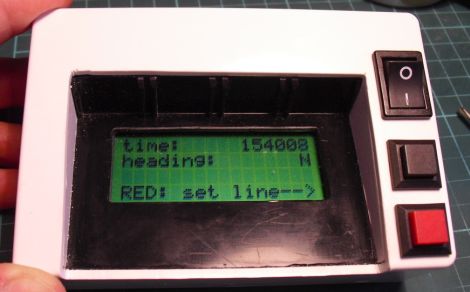
Reverse Geocache Features UI And Is Reprogrammable

Here is yet another offering in the Reverse Geocache puzzle arena. We’ve been getting a lot of tips about these projects but this one in particular stuck out from the others. [Mure] packed in a bunch of features, starting with the LCD screen seen above. You can just make out the single red button near the bottom of the image which is used to traverse the menu. The octagonal box has an octagonal PCB inside that includes a USB connector. As you can see in the video after the break, this can be used for charging the batteries, and communicating with the internals. An accompanying program is used to generate puzzle data, which can then be programmed via that USB connection to set a new puzzle location. This functionality certainly protects against accidental lock-outs which were a problem with the last puzzle we looked in on.