Keeping Tabs On Your Tabby With A Camera And GPS

cat_eye_pictures_and_gps

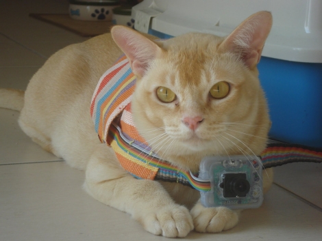
[Janis] has an outdoor cat that likes to roam all over the neighborhood. He was curious to see what he was up to all day, so he decided to build a small cat cam to document the feline’s comings and goings. After the cat returned one evening with a snail riding along on his back, [Janis] thought it would be pretty interesting to see where the cat was going as well.

He calls his creation “CatEye”, and it consists of a small JPEG color camera and GPS sensor, both of which are managed by what looks to be an ATMega328. The camera snaps pictures as the cat roams around, while the GPS sensor records its location throughout its travels. All of the data is stored on an SD card, making it easy to transfer the pics and .KML files back to his computer. A few clicks later, he can see everywhere his cat has been, using Google Earth.

It seems like a pretty interesting project, and we would love to see some schematics and code so that we can strap one of these on [Caleb] our cat to see where he’s been all day.


Play-by-play Of A High Altitude Balloon Flight

[Greg Intermaggio] and [Shumit DasGupta] at Techsplosion launched a high altitude balloon last week that climbed to 90,000 feet above sea level somewhere over California. The play-by-play of the flight is one of the better stories we’ve seen on high altitude balloon builds.

The balloon, christened VGER-1, carried a SPOT satellite GPS messanger to send telemetry back to the ground. We’ve seen a few home brew balloon tracking devices, but [Greg] decided to use an off-the-shelf solution for the sake of simplicity. Like other balloons the VGER-1 carried a CanonPowershot camera with CHDK firmware.

Continue reading “Play-by-play Of A High Altitude Balloon Flight”

Race Car POV LED Displays

race_car_pov

Last year, when [Alex] was asked by his friend [Martin] to help him out with building some LED POV modules for a race car, his response was a enthusiastic “YES!”

[Martin’s] goal was to involve fans more deeply in the race, so he decided that the POV modules would carry messages from fans on-board, printing them in the night as the race cars screamed around the track. The pair started prototyping and testing a design, wrapping things up shortly before this year’s 24 hours of Nürburgring.

The modules consist of an Arduino-compatible AVR, a GPS module, a 16-LED light bar, and the circuitry for driving the LEDs. While most of the components are pretty standard fare, the we don’t often see a GPS sensor built into a POV display. [Alex] says that the sensor is used to calculate the speed of the cars, ensuring a uniform font size.

They took their LED displays to the 24 hours of Nürburgring, where they were invited by Audi to install the modules on a pair of R8 Le Mans race cars. As you can see by the pictures on his blog and Flickr set, the POV units worked out nicely without having to stretch the camera exposure times too far.

If you’ re interested to hear a bit more about how the displays were built, check out this entry in[Alex’s] blog, where he goes through some additional details.

Update:[Alex] pointed us to the videos!

GPS Lap Timer From Secondhand Parts

gps_racing_lap_timer

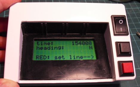
Hackaday forum member [nes] was training for an endurance race, and rather than having someone verbally call out his lap times, he wanted something he could keep in-vehicle to help keep track of his performance. With the race budget running dry, he and his teammates needed something cheap, if not free, to get the job done.

He scored a “broken” GPS receiver on eBay for a measly £4 and found that the receiver worked, but corrupted software prevented the unit from mapping routes. Since he didn’t require routing functions to keep track of his lap times, he splayed the GPS receiver open and started hunting around for a serial bit stream. He found what he was looking for after a bit of probing and hooked it up to his computer to see if the data contained NMEA sentences.

He cut the receiver down to the necessary parts and then started work on the lap timer itself. The timer uses an ATMega32 to run the show, displaying relevant time and location information on an LCD panel he scavenged from the trash bin.

He admits that the wiring is a bit questionable, but says that after about seven hours of rough use, everything is still intact and working great.

GPS Without GPS

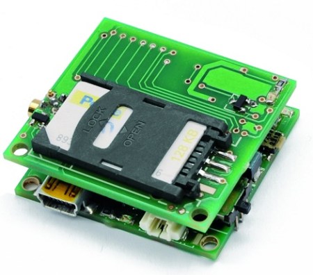
Open Electronics just released a neat little board that can place you on a map without using GPS.

The board works on the basic principles of a cellphone network – the ‘cell’ network is a series of towers that are placed more or less equidistant to each other. Save for the most desolate parts of the country, a cell tower usually communicates with a phone one or two miles away. Usually, several cell towers can be seen, so the position of a cellphone can be pinpointed to within 200-350 feet. Translating cell towers to latitude and longitude is easily done by querying a Google database that was created for the mobile version of Google Maps.

The board itself is a PIC18 microcontroller and a SIM900 GSM module. The firmware available at Open Electronics is pretty impressive – all communication to the board is handled through SMS and the phone can report it’s location to 8 other phones.

It’s pretty impressive to think the same technology that caught [Kevin Mitnick] is now available to the masses. We’re wondering what Hack a Day readers would use this for, so if you have an idea leave a comment.

Forearm-mounted GPS Uses LEDs To Light The Way Home

arm_mounted_gps

While some people can rely solely on memory and landmarks to find their way home, others need a bit more help. Consider Instructables user [_macke_] for instance.

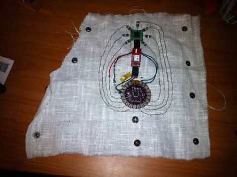
Like other screenless GPS navigation devices we have seen, his “Find Home Detector” uses a GPS module to obtain his location, guiding the way home via a set of alternate indicators. In this case, he uses LEDs which are laid out like a compass rose. When [_macke_] is aimed toward his destination, the LED nearest to his fingertips lights up, letting him know he is on the right path. As he turns away from home, the other LEDs light, indicating the direction in which he should turn.

His forearm-mounted GPS navigator uses a LilyPad Arduino to control the system, much like others we have seen. It is connected to a GPS sensor and a compass module that work in concert to guide him home. The compass is responsible obtaining his heading information, and while it might look as if the LEDs that surround the module are pointing North, they are in fact indicating the heading of his destination instead.

It’s a cool little creation, and we can imagine it would be quite helpful if you happen to be walking home after a long night of drinking.

Be sure to check out the video below for a quick demonstration.

Continue reading “Forearm-mounted GPS Uses LEDs To Light The Way Home”

Arduino Hits The Battlefield — For Real

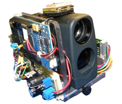
We’re not sure if this is the first time, but here’s some pretty solid proof that Arduino has found its way into the weapons of war. The creators, [Derek Wales], [John Eischer], and [George Hopkins] are all Electronics Engineering majors at West Point. They came up with this idea after seeing video footage of a firefight in Afghanistan where combat soldiers were calling in artillery strikes using a compasses and GPS devices. It’s an all-in-one unit that can provide the same information quickly and accurately. The prototype above, which they call the DemonEye, contains a laser range finder, digital compass, and a GPS module. The article also states that it contains a mini-computer but we recognize that as an Arduino Mega (thanks to Miguel over at Areopago 21 for noticing this first and sending in the tip about it).

The prototype apparently comes in at $1000. Okay, it seems a bit high but not out of the ballpark. What we can’t understand is how the second generation of devices was billed out at $100,000 for five more units. What’s the going rate for laying out military-grade PCBs?