If you have a 3D printer, your nozzle and heater block are invariably covered in a weird goo consisting of decomposed and burnt plastic. There’s only one way around this – a nozzle sock, or a silicone boot that wraps around the heater block and stops all that goo from accumulating.
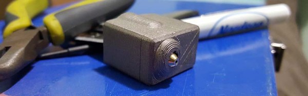
Right now, E3D sells silicone nozzle socks for their normal-sized heater blocks, with a release for their maxi-sized Volcano blocks coming shortly. [Ubermeisters] couldn’t wait, so he designed a 3D printed mold to cast as many Volcano nozzle socks as he could ever need.
The mold itself is taken from the mechanical drawings of the E3D Volcano hotend, printed in Proto Pasta HTPLA. To create the nozzle sock, this mold is filled with a goo made from GE Silicone I, mineral spirits, plaster of Paris, carbon powder, aluminum powder, titanium microspheres, and bronze powder colorant from Alumalite.
The mold is sprayed with release, filled with silicone goo, and slowly brought together. After a few hours, the silicone has cured, can be removed from the mold, and the flash can be cut away from the finished part. The end result is great — it fits the Volcano hotend well, and shouldn’t be covered in melted, burnt plastic in a week’s time.
All the files for the Volcano nozzle sock mold can be found on YouMagine. Alternatively, you could wait another month or two for E3D to release their ‘official’ Volcano nozzle sock.