You Draw It, CNC Cuts It

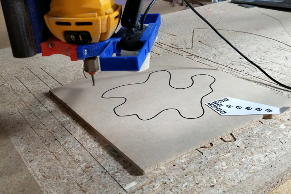
[Jamie] aka [vector76] hit us with a line-tracing plugin for OctoPrint that cuts out whatever 2D shape you draw on a piece of wood. The plugin lets you skip the modeling step entirely, going straight from a CNC-mounted webcam that reads your scribbles and gives you a Gcode toolpath in return. The code is on GitHub and there’s a demo video embedded below.

Under the hood, OpenCV is doing a lot of the image processing, including line detection, and the iterative “find the line” and “move the toolhead” steps really show off what computer vision can do. It starts off with a fiducial arrow for scale and orientation, then it mores the webcam around the scene. The user can enter the usual milling parameters: speeds, feeds, depth of cut, tool offset, milling direction, etc. And then it gets to work.

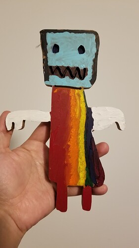
Right now, it’s limited to paths with non-crossing lines, and probably with good contrast and a nice dark line — all the usual CV restrictions. But mounting a webcam to a CNC toolhead and using it for various pathing problems really opens up tons of possibilities: visual homing, workpiece edge finding, copying parts, custom fitting odd shapes, and more. This project is clearly an invitation to keep on hacking, an appetizer. Once you see the girl pirate robot that [Jamie]’s daughter made, you’ll get the idea.

We’ve seen a similar OpenCV approach used for center-finding bore holes, but while we’ve seen a few webcams used with laser cutters, the CNC mill applications seem largely untapped. Let us know in the comments if you’ve got some other good examples.

Continue reading “You Draw It, CNC Cuts It”

Robots Learning To Understand Their Surroundings

Today it is pretty easy to build a robot with an onboard camera and have fun manually driving through that first-person view. But builders with dreams of autonomy quickly learn there is a lot of work between camera installation and autonomously executing a “go to chair” command. Fortunately we can draw upon work such as View Parsing Network by [Bowen Pan, Jiankai Sun, et al]

When a camera image comes into a computer, it is merely a large array of numbers representing red, green, and blue color values and our robot has no idea what that image represents. Over the past years, computer vision researchers have found pretty good solutions for problems of image classification (“is there a chair?”) and segmentation (“which pixels correspond to the chair?”) While useful for building an online image search engine, this is not quite enough for robot navigation.

A robot needs to translate those pixel coordinates into real-world layout, and this is the problem View Parsing Network offers to solve. Detailed in Cross-view Semantic Segmentation for Sensing Surroundings (DOI 10.1109/LRA.2020.3004325) the system takes in multiple camera views looking all around the robot. Results of image segmentation are then synthesized into a 2D top-down segmented map of the robot’s surroundings. (“Where is the chair located?”)

The authors documented how to train a view parsing network in a virtual environment, and described the procedure to transfer a trained network to run on a physical robot. Today this process demands a significantly higher skill level than “download Arduino sketch” but we hope such modules will become more plug-and-play in the future for better and smarter robots.

[IROS 2020 Presentation video (duration 10:51) requires free registration, available until at least Nov. 25th 2020. One-minute summary embedded below.]

Continue reading “Robots Learning To Understand Their Surroundings”

Autonomous ATV

[youtube=http://www.youtube.com/watch?v=Ja3ND8Pk_0M&hl=en&fs=1]

A team at UNC Charlotte has been working on an autonomous vehicle to drag a cart that has sensing equipment. Starting with a stock Honda ATV, different systems were added to give a Renesas processor control of the ATV.  A model airplane receiver was attached to the Renesas to give remote control for Phase 1 of the project. Basically they’ve turned the ATV into a giant remote controlled car.

Later revisions will incorporate LIDAR, cameras, and multiple GPS units so the ATV can autonomously traverse most terrain with a high level of accuracy. Path planning will become a large part of the project at that point.

Continue reading “Autonomous ATV”