The Global Positioning System (GPS) was developed by the United States military in the 1970s, but it wasn’t long before civilians all over the planet started using it. By the early 2000s the technology was popping up in consumer devices such as mobile phones, and since then its become absolutely integral to our modern way of life.
But although support for GPS in our gadgets is nearly ubiquitous, it’s not the only option when it comes to figuring out where you are on the globe. As you might imagine, not everyone was thrilled with building their infrastructure around one of Uncle Sam’s pet projects, and so today there are several homegrown regional and global satellite navigation systems in operation.
As a follow-up to our recent dive into the ongoing GPS upgrades, let’s take a look at some of the other satellite positioning systems and who operates them.
GLONASS (Russia)
Given the tensions of the Cold War, it will probably come as little surprise to learn that the Soviet Union introduced their own satellite-based navigation system to compete with GPS. Development of the Global Navigation Satellite System (GLONASS) started a few years later than its Western counterpart, with the first satellites not reaching orbit until 1982, officially making it the second Global Navigation Satellite Systems (GNSS) ever developed.
GLONASS satellites orbit at a slightly lower altitude than GPS, 19,100 kilometers (11,900 miles) compared to 20,200 km (12,600 mi) of the American system, and at a greater inclination. This makes reception better at higher latitudes, which makes sense given the desired coverage area.
As designed the capabilities and overall accuracy of GLONASS were very similar to GPS, but the early satellites had a short operational lifespan of just three years. For global coverage GLONASS required 24 satellites in orbit, and maintaining coverage over Russia required 18. But after the fall of the USSR, launches of new satellites were put on pause and the constellation started suffering losses. By 2001, there were just seven operational GLONASS satellites.
President Vladimir Putin made the restoration of GLONASS a key priority in his administration, leading to resumed launches and development of the second and third generation satellites. Within a few years, commercial interest in GLONASS started to pick up, and the network regained global coverage in 2011. While the constellation has experienced a few setbacks over the last several years, spare and replacement satellites have been launched regularly, with the most recent entering orbit in September of 2025.
BeiDou (China)
Unlike the American and Russian systems, the first iteration of BeiDou was of a much smaller scale. Rather than a global system, the goal was to provide regional coverage for China and the surrounding countries with just four satellites placed in a geostationary orbit at an altitude of approximately 35,786 km (22,236 mi). From an observer in China, the satellites would appear to be motionless in the sky, ensuring reception anywhere in the country. Known retroactively as BeiDou-1, the system was operational from 2003 to 2012.

That year it was replaced with the far more ambitious BeiDou-2. The design called for a constellation of satellites in various orbits: 5 geostationary to provide backwards compatibility with BeiDou-1, 27 in medium Earth orbit similar to GPS/GLONASS, and 3 in an inclined geosynchronous orbit. The latter meaning that from the perspective of Earth, the satellite would appear to loiter overhead rather than remain in a fixed position.
BeiDou-1 was largely a research project and saw little use outside of the Chinese government. Conversely BeiDou-2 was designed for both government and civilian use from the start, with two distinct levels of service — civilian users could plot their position within a radius of 10 meters (32 feet), while the military reportedly enjoyed an accuracy of 10 cm (4 inches).
The coverage area of BeiDou-2 was expanded considerably to the south to include include Indonesia and Australia, but it still didn’t provide global service. Commercial use of the network started to pick up at this point, and by 2014 smartphones from Sony, Samsung, and Xiaomi included support for it.
It wasn’t until the introduction of BeiDou-3 in 2015 that the system could boast global coverage, with the system reaching full operational status in June of 2020.
Galileo (European Union)
While civilian use of GPS, GLONASS, and BeiDou was always part of the plan, all three systems were ultimately designed as tools of their respective governments. Conversely, when the European Union set out to develop Galileo in the early 2000s, the goal was to create a satellite navigation system operated by private companies and aimed at civilian users.
That first part of the plan fell apart fairly quickly, and by 2006 Galileo was nationalized and the European Space Agency was entrusted with its development and operation. The first operational satellite was put into orbit in October 2011, and limited functionality was available to the public by 2016. While Galileo was designed for civilian use, it does offer a High Accuracy Service (HAS) with an accuracy of 20 cm (8 inches) that was initially intended to be accessible only by paying customers. But eventually it was decided to make HAS available to compatible receivers free of charge. When combined with its interoperability with GPS and GLONASS, Galileo offers exceptional accuracy.
Galileo reached full operational status in 2024 with a constellation of 24 satellites. Starting in 2027, these will be joined by a dozen upgraded Galileo Second Generation (G2) satellites that feature more electric propulsion for more efficient orbital maneuvers, improved antennas, and inter-satellite data links.
QZSS (Japan)
Development of the Quasi-Zenith Satellite System (QZSS) started in 2002, with the goal of offering high-accuracy position services to users in and around Japan. But rather than operating independently, QZSS was designed to augment GPS with five additional satellites.
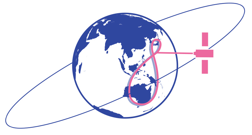
Two of the satellites are in a geostationary orbit similar to those used in China’s BeiDou-1 system, while the other three are in a geosynchronous orbit like those introduced with BeiDou-2. These orbits are intended to keep at least one satellite directly over Japan at all times to improve reception in urban areas. The system became fully operational in 2018.
In the near future, Japan plans on adding three more satellites to the QZSS constellation. This would give the system enough regional coverage to operate independently of GPS if necessary.
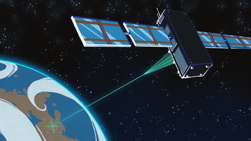
NavIC (India)
Navigation with Indian Constellation (NavIC), previously known as Indian Regional Navigation Satellite System (IRNSS), is an independent regional navigation system that covers India and the surrounding area using seven satellites.
Development of NavIC started in 2006, and the first satellite was launched in 2013. Like QZSS, the constellation is made up of satellites in both geostationary and geosynchronous orbits. Two levels of service are offered: the Standard Positioning Service for civilian use that offers an accuracy of 3 m (9.8 feet), and an encrypted Restricted Service intended for military and government applications that’s accurate to 2 m (6.7 ft)
One of the goals of NavIC was not only to launch and operate the system from within India, but to produce as much of the hardware domestically as possible. This includes the atomic clocks and microprocessors aboard each satellite as well as the receiver chips used in client devices. While India wanted to maintain ultimate control over NavIC for political reasons, it’s not an isolationist system — it is designed to be interoperable with other GNSS.
That last point is particularly important right now, as only three NavIC satellites are currently transmitting navigational data due to hardware issues. Those three satellites alone aren’t enough to plot an accurate position, so to compute their location receivers must pull in data from other systems such as GPS.
Better Together
Although having so many active satellite navigation systems may seem redundant, the fact that they all offer at least some level of interoperability with each other means that everyone with a multi-system receiver can benefit. Instead of being limited to the constellation of just one service, this cross compatibility lets a device pull in data from whatever satellites are overhead at the time.
Granted how much of an improvement this results in will be highly dependent on where you’re located on the globe, but no matter what, its always going to be better than being limited to just one system.


Not sure I’d feel comfortable putting my navigational eggs in a Chinese or Russian basket. Ability to use all available resources, though, is probably a good idea.
Why? The entire point is that you use ALL of them if you can. I wouldn’t trust just GPS, nor would I just trust GLONASS or Galileo or BeiDou. That’s the point.
The GPS at my desk is currently connected to: GPS (11 sats), GLONASS (8 sats), Galileo (9 sats), BeiDou (3 sats). It should have a precision of less than 1cm using kinematics at the moment.
It does all at the same time so if one of them was to be incorrect by shifting something, it would automatically correct for it based on the other systems because it can do that. If it was just GPS, it would not be able to correct itself, which used to be a major problem with GPS as GPS was faulty on purpose. GPS used to have a shift in it so the receiver wasn’t in the exact spot it thinks it is. This was by design and you needed a special license from the US DoD to have a corrected signal. The same thing is currently done in China with a special shifting method. You can’t use a normal GPS map to pinpoint a place as they use a weird shifting method. They don’t do that for things outside China as far as I know so it’s not usually a big deal. All of these shifts are fine for the average person in a car with a tiny GPS device (TomTom/Garmin/Mio etc) like people had back in the days, or a phone like people use now, because they aren’t precise and if you are 20 meters off target it’s not a big deal. If you need precision you need multiple different positioning systems at the same time so it can correct itself and if you can, use kinematic corrections for precision. The more systems are up and running in the sky, the less change you have of it being faulty and with segmented antenna’s and anti spoofing systems, you aren’t likely to run into issues anymore.
I’m more than happy to put my navigational eggs in western, Russian, Chinese, Indian etc baskets all at the same time, because I don’t trust any of them on their own. Past results do not guarantee future performance but I don’t trust anyone.
I don’t see how that could work. All of the systems broadcast a time signal and some information about where in its orbit the satellite is. The satellite doesn’t know anything about where the receiver is. Even if it did, it couldn’t transmit a different signal to different receivers based on the receiver location. They broadcast the signal. They do not transmit a directed signal to each receiver.
The most you could do is to have the satellite diddle with the signal depending on whether or not the satellite is above Chinese territory. That would cause shifting of the signal for receivers outside of China as well, though. The satellite broadcast pattern covers a large area. Even when a satellite is well inside of China, the signal will still be visible to receivers outside of China.
GPS applied a random dithering to the clock data transmitted in the civilian signal. You weren’t merely “not where you think you are.” You were also not where you were a moment ago.
GPS was designed to provide 10 meter accuracy on the military signal and 100 meter accuracy on the civilian signal. In actual practice, the civilian receivers were getting 10 meter accuracy while the military was getting 1 meter accuracy. With the civilian signal providing an accuracy that was deemed sufficient for military use, the US opted to make civilian signal less accurate.
As time went by, the US shut off the fuzzing (selective availability (SA)) in favor of letting civilian shipping and air traffic use GPS with good accuracy. That made it reliable and accurate enough for road navigation. As far as I know, the system is still capable of SA. It is just shut off.
Interlinking adds redundancy and a higher level of accuracy as well.
Thankfully, most of the GOS designed-in issues were pretty much ended, but reliance on a single nav system today, is a fool’s errand.
Hopefully, out planet can get past the government created issues, and we must work for society, not remain slaves to our servants in this era.
We created all we have, it is time to force our will and unite us all for a common goal, not the garbage of the cold war era.
Higher accuracy means ships at sea can be rescued faster, with less time swapping location services depending on where you are.
That, must end, and we are all stuck, HERE!
Work together, and make life better for all.
The sun is probably the bigger worry than any nation state.
Also add to the futures list: Starlink and PNT.
North America and Hawaii have WAAS (Wide Area Augmentation System). Do other systems have similar ground-based enhancements?
“…At the moment, EGNOS only works with GPS signals, but the upcoming version (EGNOS v3) will also include Galileo support.
EGNOS accomplishes this improved accuracy with the help of more than 40 ground stations across Europe…”
Only three WAAS sats remain operational. The promise was a Cat I approach to any podunk landing strip. Me and my little GA plane are still waiting while the FAA twiddles its collective thumbs on published/approved approaches and recievers.
WAAS/LAAS/GBAS will not be made easily and cheaply available by this FAA’s admin.
Nor has it been made available easily and cheaply by any previous administration.
Just to keep things in perspective.
Only because it has not been made a priority.
Well now I want my country, Canada, to make and launch its own navigation satellite constellation as well.
I guess, with enough LOX, you could power a rocket with maple syrup ;)
As helpful as modern tech is, it’s still useful to know how to find your approximate location using the stars and a way to measure their angle to the horizon, a good clock set at a known location, and maps, charts, and tables. For “local” locations on the ground, it’s good to know how to find it with a compass, a map, and some visible landmarks.
+1
I think the basics, such as using a sextant, are still being thaught in seafaring/space travel.
Knowing morse telegraphy and how to build a simple radio receiver/transmitter would be good, too.
As common knowledge, I mean. Like in elementary school.
There was a time when 6 year old built crystal receivers all alone.
Or sun dials, simple compasses etc.
People should still learn the principles, but they’re automating celestial navigation as well https://www.gpsworld.com/honeywell-demonstrates-military-grade-alternative-navigation-tech/ . If we’re unlucky we’ll see the first spoofing/jamming attacks on it too
I wonder whether/when GPS would have been opened to civilian use had it not been for the Russians shooting down Korean Airlines flight 007 in 1983 when it wandered into Russian airspace due to navigation errors. President Reagan opened up non-military use afterwards and I think it was the right decision to share it with the world.
I think it wandered in by more than 100m. Besides, commercial aviation uses INS.
Nice overview. I would appreciate a follow up detailing how GNSS works, and also some info on RTK and NTRIP which are in my mind close to pure magic.
Jeff Geerling also have some cool videos of non-GNSS positioning technology.
NTRIP is just a protocol to broadcast RTK corrections via a network connection, either over the internet or a local network.