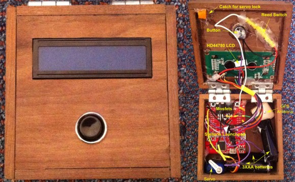
A Low-Cost Modular High Altitude Balloon Tracker With Mesh Networked Sensors

[Ethan] just tipped us about a project he and a few colleagues worked on last year for their senior design project. It’s a low-cost open hardware/software high altitude balloon tracker with sensors that form a mesh network with a master node. The latter (shown above) includes an ATmega644, an onboard GPS module (NEO-6M), a micro SD card slot, a 300mW APRS (144.39MHz) transmitter and finally headers to plug an XBee radio. This platform is therefore in charge of getting wireless data from the slave platforms, storing it in the uSD card while transmitting the balloon position via APRS along with other data. It’s interesting to note that to keep the design low-cost, they chose a relatively cheap analog radio module ($~40) and hacked together AFSK modulation of their output signal with hardware PWM outputs and a sine-wave lookup table.

The slave nodes are composed of ‘slave motherboards’ on which can be plugged several daughter-boards: geiger counters, atmospheric sensors, camera control/accelerometer boards. If you want to build your own system, be sure to check out this page which includes all the necessary instructions and resources.

Using A Raspberry Pi To Give Your Car More Features

[Andrei] is cruising in style thanks to his Raspi-powered CarPC project, which is a steal at $200 considering all the functionality it provides. This is an update to the work we saw from him back in March. Rather than completely replace his car’s head unit, [Andrei] simply relocated it to the trunk, permanently set it to the “aux input” source, and connected the Raspberry Pi’s audio output. The Pi runs a Raspbian Wheezy distro with XBMC and is mounted in the storage area beneath the middle armrest. [Andrei] filled the hole left by the old stereo with a 7-inch touchscreen display, which connects to the Pi through both HDMI and USB. If you throw the car into reverse, the Pi automatically selects the touchscreen’s AV input to display the car’s backup camera, then flips back when put in drive.

The unit also provides navigation via the open-source Navit software using OpenStreetMap data. An ST22 SkyTraq GPS receiver grabs coordinates and feeds them into the Raspi, which updates the on-screen map once per second. You’ll want to watch the video after the break (Audio Warning: Tupac) to see for yourself just how well the CarPC came together,

Continue reading “Using A Raspberry Pi To Give Your Car More Features”

Fail Of The Week: GPS Module Design

GPS is really fun to play with in your projects. But when [Trax] decided to build a GPS chip into his design the fun ended abruptly. Above you can see the section of the board devoted to the hardware. Unfortunately this PCB fails to provide any GPS location data whatsoever.

Continue reading “Fail Of The Week: GPS Module Design”

Raspberry Pi Replaces A Volvo Nav System

rpi-replaces-volvo-nav

[Reinis] has a Volvo S80. One of the dashboard features it includes is a 6.5″ LCD screen which periscopes up to use as a navigation system. The problem is that Volvo stopped making maps for it around five years ago and there are no maps at all for Latvia where he lives. So it’s worthless… to you’re average driver. But [Reinis] is fixing it on his own by replacing the system with a Raspberry Pi.

That link leads to his project overview page. But he’s already posted follow-ups on hardware design and initial testing. He’s basing the design around a Raspberry Pi board, but that doesn’t have all the hardware it needs to communicate with the car’s systems. For this he designed his own shield that uses an ATmega328 along with a CAN controller and CAN transceiver. The latter two chips patch into the CAN bus on the car’s On Board Diagnostic system. We didn’t see much about the wiring, but the overview post mentions that the screen takes RGB or Composite inputs so he must be running a composite video cable from the trunk to the dashboard.


Autonomous RC Car Navigates By Waypoints

autonomous-rc-car

Check out this autonomous RC car which [Jason] built for the chipKIT design challenge. It’s been able to successfully navigate a planned route taking just a few waypoints as inputs.

Obviously this uses a chipKIT as the controller, the max32 to be specific. [Jason’s] write-up shows off all of the components of the design, but you’ll have to head over to his recently posted update to hear about the custom board he had spun to host them all. It starts with a GPS module, but that’s only accurate enough to give the rover the big picture. To handle getting from one waypoint to the next successfully he also included a gyroscope which provides very accurate orientation data, as well as optical encoders on the wheels for on-board distance traveled information.

We hope he’ll keep refining the design and make a trip to next year’s Autonomous Vehicle Competition.

Continue reading “Autonomous RC Car Navigates By Waypoints”

This GPS Logger Is So Small…

small-gps-logger

How small is it? Two things should give you a good sense of scale, the SD card slot on the lower right, and the slide switch on the upper left. This minuscule module is an all-in-one GPS logger which [J3tstream] built.

Main system control is provided by a Teens 2.0 board. If you look really closely you’ll see the SD card slot is actually a breakout board which mounts on top of the Teensy’s pinheaders. Also on the board is a PA6B GPS module with a few passive components to support it. The back side of the board hosts a Lithium Ion battery from an old phone. Note the mangled pin header which works as connectors for the battery. [J3tstream] even built a charger into the project. He’s using an LTC4054 chip to handle the charging. We were a bit confused at first because we didn’t see a way to connect external power. But he goes on to explain that the USB port on the Teensy board is used for charging. Just plug in USB and press the button to get things started.

FAA GPS Data Formatted For Your Use

faa-gps-data-formatted-with-vb

[Michael] posted up-to-date GPS data sets in the GPX format.  These data sets are an alternative to paid updates. Since GPX is a published standard which uses an XML style formatting for location data [Michael’s] time was spent getting the original sets and finding a way to translate them for his Garmin EXTREX GPS.

The original data comes from — hang on, this is a mouthful — the US Federal Aviation Administration’s Facility Aeronautical Data Distribution System (FADDS). He had to apply for permission to download it and to use it in producing a custom GPS build. He grabbed the Airport waypoints and navaid sets, then studied accompanying files detailing the data structure before writing his own Visual Basic 2010 program to spit out the GPX files. He says he wanted to make them available in the spirit of the Open Hardware/Software movement. This may be most interesting for pilots (the kind that put Nooks on the dashboard, not the kind who watch the aircraft from the ground), but we’re sure there’s a myriad of uses for non-pilots alike.