Using Public Data To Make Laser Cut Maps

laser cut maps

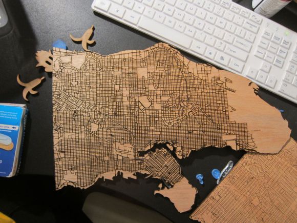
If you have access to a laser cutter you’re going to want to take a look at this brilliant tutorial. [Steven Smethurst] has figured out how to extract public map data and turn it into a file ready to be laser cut onto your choice of material.

In his example he’s using Vancouver’s Open Data Catalog to build his map using the coastal and public street data. To do this he’s using a program called TileMill which you can get for free from MapBox — it’s a great piece of software for designing your own interactive maps — and the best part is, you can import data from a wide variety of sources, such as Vancouver’s Open Data!

You can import the shape (.SHP) files from the Open Data Catalog and add them as layers into TileMill. From there you can manipulate your map, adjust the detail, and then import as a .SVG or .DXF file ready for laser cutting.

In addition to the Instructable on how to do this, he’s also recorded an in-depth video tutorial which you can check out after the break.

Continue reading “Using Public Data To Make Laser Cut Maps”

Hacking A Flatbed Scanner To Scan Very Large Documents

lds

When you need to scan really large documents, camera setups can get pretty expensive. There are professionals that do it, but they are fairly pricey too. What if you need to do it on the cheap? A flatbed scanner would be perfect, but the lip on the edge of most flatbed scanners keeps the document from touching the platen properly. [Matthew] decided to hack his Canon LiDE 90 scanner to use it in a face-down format. By removing the top of the case, and making a couple extra tweaks, the scanner can now lay flat and simply be moved in a grid.

Once you have the images, you’ll need a way to stitch them together. [Matthew] points to this tutorial, but he awesomely decided to write a little Python script to make it all happen automatically. We imagine that script might be useful for more than just this project.

We’ve seen some other scanners recently, but this one is probably the easiest for the majority of hobbyists to achieve with parts on hand.

GSM Tracking Without GPS

If you use the Google Maps Mobile function then the big G knows where you are even if your phone doesn’t have a GPS module in it. So the next time you want geolocation capabilities in a project consider building around GSM functionality which can also be used for Internet connectivity. That’s exactly what this module does and luckily the hard work has already been done for you.

The method really hinges on a couple of things. First of all, any GSM capable device knows the information about the cell it is currently communicating with. Secondly, Google knows the coordinates of radio towers used in the cellular mobile network. A little bit of data sniffing on Google Maps Mobile app communications confirms how and when cell information is transferred between the device and the maps server. Take a look at this series of write-ups which go into detail about hardware, software, cell network location data, and communication protocols which Google hasn’t publicly documented. Sure you’re not going to have the accuracy we’ve come to enjoy with GPS, but this can get you pretty close.

[Thanks Boris]

Google Maps Wristlet Navigator

This on-wrist navigation system uses Google Maps and something called… paper. This is a throwback to scroll-based directions from the 1920’s and 30’s that [Simon] built. He soldered a couple of brass tubes to a brass back plate, then added sides and a face crystal. Now he prints out step by step direction from the popular mapping website and winds them onto scrolls. We’re not sure that we’d take the time to do this, but hey, at least the screen resolution is fantastic and you don’t have to worry about battery life.

Google Bike Hack, Quick And Dirty

Many of the projects we post are so well thought out and engineered, they could hardly be called “hacks”.  This one, however, falls neatly into the hack category. [Dave] wanted his very own exercise bike hooked to Google maps. Instead of setting up a control system and writing software to control Google maps, he simply hacked a USB game controller. He wired a magnetic switch directly into the board, where the “up” button is. Then he mounted the switch so that it would be triggered each time he rotated the pedal.  Though he only has the forward movement done right now, it would be pretty easy to set up a couple more switches at the base of the handle bar for left and right.

While the experience may not be quite as nice as the more complicated one, aside from head tracking, it isn’t that far off.

Map Abstraction API In Javascript


Maybe you’ve tinkered a bit with the Google Maps API. Most of the software produced with it is not all that useful or entertaining, but a few gem have shone through. Still, wouldn’t it be better if applications produced with it could be easily ported to other online mapping services like Mapquest or Yahoo! Maps?

This is possible with Mapstraction, a Javascript API that works with nine mapping services and plans to incorporate more into the fold. Mapstraction has open-source features that normalize functions across the biggest services, which makes searching for map data a consistent, predictable experience no matter which service you use.

Some of Mapstraction’s current features are what you would expect: point, line, and polygon support, image overlay, GeoRSS and KML feed importing, and several others. We’re really looking forward to future versions with OpenStreetMap support. Currently Mapstraction works with only commercial mapping services, but OpenStreetMap combined with Mapstraction directly hits the sweet spot; a customizable, open source map.

[via Hackszine]