Where’s The Cat? Locating Your Moggy Without Eating Batteries

Where the Hackaday Cat goes when she steps over the threshold into the wider world is a mystery, she reveals her whereabouts strictly on her terms and would we suspect be very cagey were we able to ask her about it. [Andy C] however has a need to know where his cat is spending her time, so he’s made a GPS collar for a bit of feline spying.

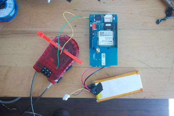
There are commercial GPS collars for pets, but they all share the flaw of extremely limited battery life. His challenge then was to create a collar that delivered the required pinpoint fix alongside a battery life measured in months. The solution was a combination of a low-power miniature GPS receiver and a low-power PC microcontroller hooked up to an FSK radio whose frequency he doesn’t give but which we suspect is probably the usual 433 MHz. The collar remains in low power mode until it receives a call on the FSK, at which point it wakes up, gets a GPS fix, transmits it, and returns to sleep.

The summary links to a series of posts which provide an extremely detailed look at all aspects of the project, and go well beyond mere GPS trackers for a cat. If you have an interest in low power devices or antenna matching for example, you’ll find a lot of interesting stuff in these pages. Of course, if all you need is a GPS tracker though, you may prefer a simpler option.

Aireon Hitchhikes On Iridium To Track Airplanes

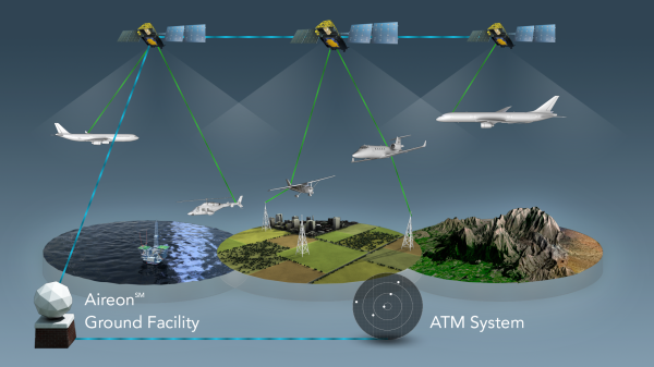
SpaceX just concluded 2017 by launching 10 Iridium NEXT satellites. A footnote on the launch was the “hosted payload” on board each of the satellites: a small box of equipment from Aireon. They will track every aircraft around the world in real-time, something that has been technically possible but nobody claimed they could do it economically until now.

Challenge one: avoid adding cost to aircraft. Instead of using expensive satcom or adding dedicated gear, Aireon listen to ADS-B equipment already installed as part of international air traffic control modernization. But since ADS-B was designed for aircraft-to-aircraft and aircraft-to-ground, Aireon had some challenges to overcome. Like the fact ADS-B antenna is commonly mounted on the belly of an aircraft blocking direct path to satellite.

Challenge two: hear ADS-B everywhere and do it for less. Today we can track aircraft when they are flying over land, but out in the middle of the ocean, there are no receivers in range except possibly other aircraft. Aireon needed a lot of low-orbit satellites to ensure you are in range no matter where you are. Piggybacking on Iridium gives them coverage at a fraction of the cost of building their own satellites.

Continue reading “Aireon Hitchhikes On Iridium To Track Airplanes”

Hackaday Links Column Banner

Hackaday Links: November 23, 2014

The 2015 Midwest RepRap Festival, a.k.a. the MRRF (pronounced murf) was just announced a few hours ago. It will be held in beautiful Goshen, Indiana. Yes, that’s in the middle of nowhere and you’ll learn to dodge Amish buggies when driving around Goshen, but surprisingly there were 1000 people when we attended last year. We’ll be there again.

A few activists in St. Petersburg flushed GPS trackers down the toilet. These trackers were equipped with radios that would send out their position, and surprise, surprise, they ended up in the ocean.

[Stacy] has been tinkering around with Unity2D and decided to make a DDR-style game. She needed a DDR mat, and force sensitive resistors are expensive. What did she end up using? Velostat, conductive thread, and alligator clips.

You know the Espruino, the little microcontroller board that’s basically JavaScript on a USB stick? Yeah, that’s cool. Now you can do remote access through a telnet server letting you write and debug code over the net.

The Open Source RC is a beautiful RC transmitter with buttons and switches everywhere, a real display, and force feedback sticks. It was a Hackaday Prize entry, and has had a few crowdfunding campaigns. Now its hit Indiegogo again.

Speaking of crowdfunding campaigns, The Mooltipass, the designed-on-Hackaday offline password keeper, only has a little less than two weeks until its crowdfunding campaign ends. [Mathieu] and the rest of the team are about two-thirds there, with a little more than half of the campaign already over.

Dude, Where’s My Car?

Someone just stole your car. They took it right underneath your nose, and you have no idea where it is. Luckily, you have a GPS tracker installed and can pinpoint the exact location of the vehicle that thief drove away with.

Having a GPS tracker in your vehicle becomes extremely useful when something unexpected happens. Taking the necessary precautions to ensure a secure tracking system can save a lot of time and money if the car suddenly disappears.

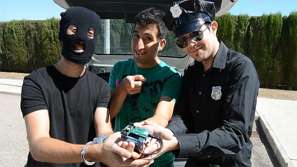
Helping to solve the vanishing vehicle problem is the bright, young team at Cooking Hacks who created a step-by-step tutorial showing how to create a homemade GPS tracker. Their design is Arduino based and has a GPS+GPRS shield with an antenna attached to continuously pick up the location of the vehicle. Making a call to the Arduino inside triggers an SMS message to be sent back with the specific GPS data of where the tracker is stationed at. Information is then set to a server and inserted into a database, which can be accessed by opening up a specialized Android app.

We’ve seen similar ideas before, like this GPS tracker for stolen bikes, but this project by Cooking Hacks is unique because of its mobile phone integration with Google Maps. Not to mention, their video for the project is fantastically awesome.

If you have developed a system like this, be sure to let us know in the comments; and don’t forget to check out their video after the break.

Continue reading “Dude, Where’s My Car?”

GPS Bike Tracker

GPS Tracker Tracks Your Stolen Bike

Bikes are great for cruising through congested cities but there is a serious downside to pedaling your two-wheeler around… bike theft. It’s a big deal, for example, yearly estimates for stolen bikes in NYC are in the 60,000 – 100,000 range. Only an extremely small percentage of those are ever recovered. [stbennett] just got himself a halfway decent bike and is not too interested in having it stolen, and if it is stolen, he wants a way to find it so he built himself a GPS tracker for his bike.

The entire project is Arduino-based. It uses a GSM Shield and a GPS module along with a few other small odds and ends. A 2-cell LiPo battery provides the required power for all of the components. It’s pretty neat how this device maintains an extremely long battery life. The metal cable of the bike lock is used as a conductor in the circuit. When the cable is inserted and locked into the lock housing a circuit is completed that prevents electricity from passing through a transistor to the Arduino. In other words, the Arduino is off unless the bike cable is cut or disengaged. That way it is not running 24/7 and draining the battery.

The entire system works like this, once the bike lock cable is cut, the Arduino wakes up and gives a 15 second delay before doing anything, allowing the legitimate user to reconnect the bike lock and shut down the alarm system. If the bike lock is not re-engaged, the unit starts looking for a GPS signal. At that time it will send out SMS messages with the GPS location coordinates. Punching those numbers into Google Maps will show you exactly where the bike is.

Of course your other option is to park your bike where nobody else can access it, like at the top of a lamp pole.

See Where Socks Has Been Using A GPS Tracking Collar

[Buxtronix] wanted to know where his cat (named Ash, but we thought Socks sounded much more cliché) was going when on the loose. He designed a GPS tracking collar and a way to map the data it collects.

The hardware actually turns out to be very simple. He needed a GPS module to gather location data, and a way to store that information having decided that live broadcast was not feasible. He hit SparkFun because they have a GPS module that is small enough for a cat collar, and outputs data with one serial pin. Unfortunately this module is no longer available, but if you have a similarly sized replacement let us know in the comments. Data capture is made easy by this device, you just need to record the serial data as it comes down the pipeline. [Buxtronix] used an OpenLog board as it dumps the data onto an SD card. When [Ash] returns from his roaming, [Buxtronix] grabs the SD card, and uses a Python script to convert the NMEA data to KML format which can be overlaid on Google Earth and Google Maps.