How Does A Sail Drone Bring Home Hurricane Footage In Record Time?

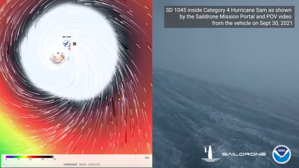
It is unlikely that as a young lad [Richard Jenkins] would had have visions of sailing into the eye of a Category-4 hurricane. Yet that’s exactly what he’s done with the Explorer 1045, an uncrewed sailing vehicle built by his company, Saildrone. If that weren’t enough, footage from the vessel enduring greater than 120 MPH (almost 200 km/h) winds and 50 foot (15 M) waves was posted online the very next day, and you can see it below the break.  We’re going to take a quick look at just two of the technologies that made this possible: Advanced sails and satellite communication. Both are visible on Explorer 1045’s sibling 1048 as seen below:

Saildrone Explorer 1048, a sibling of Explorer 1045, each one of five vessels equipped with a "hurricane wing"
Saildrone Explorer 1048, a sibling of Explorer 1045, each one of five vessels equipped with a “hurricane wing”

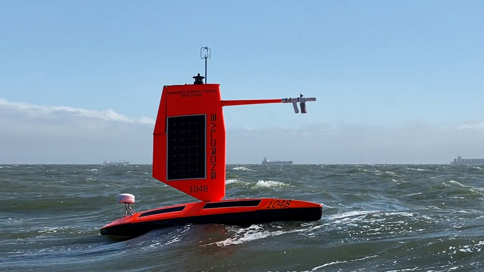
The most prominent feature of course is the lack of a traditional sail. You see, from 1999-2009, [Richard Jenkins] was focused on setting the land world speed record for a wind powered vehicle. He set that record at 126.1 mph by maturing existing sail wing technology. [Richard] did away with conventional rigging and added a boom with a control surface on it, much like the fuselage and empennage of a sailplane.

Instead of adjusting rigging, the control surface could be utilized to fly the wing into its optimal position while using very little energy. [Richard] has been able to apply this technology at his company, Saildrone. The 23 foot Explorer vessel and its big brothers are the result.

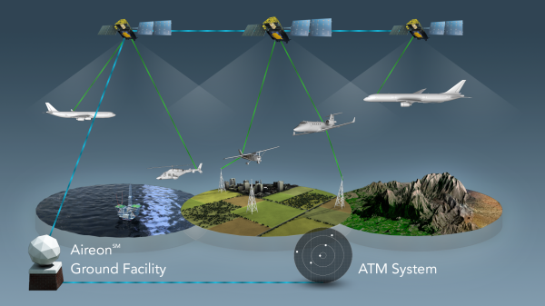
How is it that the world was treated to the view from inside the eye of a hurricane only a day after the video was recorded? If you look at the stern of the vessel, you can see a domed white cylinder. It is a satellite communication base station called the Thales VesseLINK. Thales is one of the partner companies that built the satellites for the Iridium NEXT fleet, which has 66 operational satellites in Low Earth Orbit. The Iridium Certus service uses its L-Band (1.6 GHz) signal to provide up to 352 kbps of upload speed and 704 kbps down. While not blazing fast, the service is available anywhere in the world and is reliable because it is not prone to rain fade and other weather based interference.

With just these two recent innovations, the Explorer 1045 was able to sail to the eye of a hurricane, record footage and gather data, and then ship it home just hours later. And we’re hardly exploring the tip of the iceberg. More than just sailboat based cameras, these scientific instruments are designed to survive some of the harshest environments on the planet for over a year at a time. They are a marvel of applied engineering, and we’re positive that there are some brilliant hacks hiding under that bright orange exterior.

If uncrewed sailing vessels float your boat, you might also enjoy this autonomous solar powered tugboat, or that time a submarine ran out of fuel and sailed home on bed sheets.

Continue reading “How Does A Sail Drone Bring Home Hurricane Footage In Record Time?”

Aireon Hitchhikes On Iridium To Track Airplanes

SpaceX just concluded 2017 by launching 10 Iridium NEXT satellites. A footnote on the launch was the “hosted payload” on board each of the satellites: a small box of equipment from Aireon. They will track every aircraft around the world in real-time, something that has been technically possible but nobody claimed they could do it economically until now.

Challenge one: avoid adding cost to aircraft. Instead of using expensive satcom or adding dedicated gear, Aireon listen to ADS-B equipment already installed as part of international air traffic control modernization. But since ADS-B was designed for aircraft-to-aircraft and aircraft-to-ground, Aireon had some challenges to overcome. Like the fact ADS-B antenna is commonly mounted on the belly of an aircraft blocking direct path to satellite.

Challenge two: hear ADS-B everywhere and do it for less. Today we can track aircraft when they are flying over land, but out in the middle of the ocean, there are no receivers in range except possibly other aircraft. Aireon needed a lot of low-orbit satellites to ensure you are in range no matter where you are. Piggybacking on Iridium gives them coverage at a fraction of the cost of building their own satellites.

Continue reading “Aireon Hitchhikes On Iridium To Track Airplanes”

Hackaday Prize Entry: MyComm Handheld Satellite Messenger

We live in a connected world, but that world ends not far beyond the outermost cell phone tower. [John Grant] wants to be connected everywhere, even in regions where no mobile network is available, so he is building a solar powered, handheld satellite messenger: The MyComm – his entry for the Hackaday Prize.

The MyComm is a handheld touch-screen device, much like a smartphone, that connects to the Iridium satellite network to send and receive text messages. At the heart of his build, [John] uses a RockBLOCK Mk2 Iridium SatComm Module hooked up to a Teensy 3.1. The firmware is built upon a FreeRTOS port for proper task management. Project contributor [Jack] crafted an intuitive GUI that includes an on-screen keyboard to write, send and receive messages. A micro SD card stores all messages and contact list entries. Eventually, the system will be equipped with a solar cell, charging regulator and LiPo battery for worldwide, unconditional connectivity.

2016 will be an interesting year for the Iridium network since the first satellites for the improved (and backward-compatible) “Iridium NEXT” network are expected to launch soon. At times the 66 Iridium satellites currently covering the entire globe were considered a $5B heap of space junk due to deficiencies in reliability and security. Yet, it’s still there, with maker-friendly modems being available at $250 and pay-per-use rates of about 7 ct/kB (free downstream for SDR-Hackers). Enjoy the video of [Jack] explaining the MyComm user interface:

Continue reading “Hackaday Prize Entry: MyComm Handheld Satellite Messenger”