The Perfect Tourist Techno-Cap

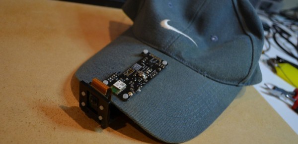
How many times are you out on vacation and neglect to take pictures to document it all for the folks back at home? Or maybe you forgot just exactly where that awesome waterfall was. [Mark Williams] has made a Raspberry Pi Zero enabled cap that can take photos and geotag them with the location as well as the attitude of the camera.

The idea is to enable the reconstruction of a trip photographically. The hardware consists of a Raspberry Pi Zero W coupled with a Raspberry Camera V2 and a BerryGPS-IMU. Once activated, the system starts taking photos every two minutes. Within each photograph, the location of the photographer is recorded like most GPS enabled camera.

An additional set of data including yaw, pitch, and roll along with direction is also captured to understand where the camera is pointing when the image was taken. Even if he’s tilting his head at the time the photo was taken, the metadata allows it to be straightened out in software later.

This information is decoded using GeoSetter which puts the images on a map along with the field of view. Take a peek at the video below for the result of a trip around Sydney Harbour and the system in action. The Raspberry Pi Zero and camera combo are useful for a lot of things including this soldering microscope. Hopefully, we will be seeing some DIY VR gear with stereo cameras in the near future. Continue reading “The Perfect Tourist Techno-Cap”

Camera Restricta Ensures Original Photography

Proper documentation is important, and when traveling it is commonly achieved via photography. Redundant documentation is often inefficient, and the Camera Restricta — in a commentary on the saturation of photographed landmarks and a recent debate on photographic censorship in the EU — aims to challenge the photographer into taking unique photographs.

Camera Restricta has a 3D-printed body, housing a smartphone for gps data, display and audio output, while an ATTiny85 serves to control the interdicting function of the camera. When the user sets up to take a picture using Camera Restricta, an app running on the phone queries a node.js server that trawls Flikr and Panoramio for geotagged photos of the local area. From that information, the camera outputs a clicking audio relative to the number of photos taken and — if there are over a certain number of pictures of the area — the screen trips a photocell connected to the ATTiny 85 board, retracting the shutter button and locking down the viewfinder until you find a more original subject to photograph.

Continue reading “Camera Restricta Ensures Original Photography”

Build A Google-style Panorama Rig For $300

PhotoTrail

As part of a “disruptive technologies” course at the United States Military Academy, [Roy D. Ragsdale] produced a working prototype of a Google Street View-like system called PhotoTrail. Like its corporate-backed inspiration, the system captures georeferenced 360-degree panoramas that can be viewed interactively in a web browser…but at a hardware cost of only around $300. [Ragsdale’s] prototype is based entirely on consumer-grade off-the-shelf components and open source software, all tied together by the yin and yang of DIY: foam core board and a few Python scripts.

This article from IEEE Spectrum magazine provides some background on the selection of parts and construction of the system, including a hardware shopping list and a list of links to all of the open source packages used.

The PhotoTrail prototype is surprisingly small and lightweight. A vehicle isn’t even required; the camera array can be carried overhead by a single person, making it possible to capture remote locations. But [Roy] expects future revisions to be even smaller and less obtrusive, perhaps mounted to a headband. Mount Everest awaits!

Flickr Photo Bike

Lifehacker’s [Gina Trapani] has one of Flickr’s photo bikes and wrote up how it works. As you ride, the bike automatically takes photographs, geotags them, and uploads them to Flickr. The handlebar unit contains a Nokia N95 cellphone. The rear is a solar powered charging unit. It has a custom python script that starts the photo taking sequence when it detects the bike is in motion using the phone’s accelerometer.

Most of the engineering seems to be for usability’s sake. We’re guessing they probably wanted to disguise that they’re bolting a $600 cellphone to a bike as well. Out of the box the Nokia N95 already does almost everything required. It has a 5 megapixel camera with an interval timer that can vary from 10 seconds to 30 minutes. It supports Flickr uploading, but with software like ShoZu you can streamline the geotagging and make all uploads automatic. Just build a solid mount for your N95 and you’ve pretty much got it, and when you park your bike you can take the phone with you.

Eye-Fi Explore Review

[flickr video=http://www.flickr.com/photos/pauls/2611298593/]

The WiFi uploading Eye-Fi SD card made a big splash when it was first introduced, but now Eye-Fi has a whole line of different products. The top of the line is the Eye-Fi Explore, which supports geotagging without using a GPS. Instead of GPS hardware, it uses the Skyhook Wireless Wi-Fi Postitioning System, which correlates the position of the Eye-Fi’s access point to GPS locations, creating virtual GPS functionality. This allows photos taken with the Eye-Fi to be be geotagged. Of course, the accuracy of the system is noticeably lower than true GPS and seems to be affected by a number of external factors, but it is still accurate enough to tag the photo within the immediate vicinity of where it was taken.

WiFi positioning is great feature, but certainly not limited to photography. Since the Eye-Fi is at its core SD storage media, you could probably have it geotag data saved to the card, even if it wasn’t created by a digital camera..