The Navy is doing some crazy stuff out in China Lake. They were planning to test something out that could potentially make GPS unusable from San Diego to Las Vegas to San Francisco. Those plans were cancelled for ‘internal’ reasons. They will be testing something in Indiana shortly, though. What are they doing? Who knows. That’s what idle speculation in the comments section is for.
3D Hubs, the distributed ‘3D printing service’ thing, now has 30,000 machines distributed around the globe. They also put together the definitive guide to 3D printing recently. For just about everyone reading this, a ‘introduction to 3D printing’ is old news, but this is a very good guide for telling your weird aunt what you’re building in the basement. Forward this one to your family on Facebook.
This one is amazing. Over on Hackaday.io, [Arsenijs] is working on a Raspberry Pi project. It uses a Raspberry Pi, and several accessories and components to make this Raspberry Pi project work. This Raspberry Pi project is already getting far more than the usual number of likes and follows, making this one of the most interesting Raspberry Pi projects in recent memory.
Moog is re-releasing the Minimoog, the original Moog synth from 1970. That’s cool, but what about a DIY Minimoog? That’s what [Scott Rider] is doing with the Crowminius Analog Music Synthesizer on Kickstarter. It’s an analog synth that’s more or less a Minimoog with MIDI, and one of the Kickstarter rewards is a bare PCB.
The future is dancing robots, so here’s a servo-driven Stewart platform that is sure to bring on the robot apocalypse.
What do you do when you need to get your Hackaday fix, but all you have is a laptop from 1995 and a dial-up modem? The Hackaday Retro Edition, of course. That’s a bunch of retro Hackaday posts, posted five at a time, with all the CSS and JavaScript cruft stripped. We’re always interested to see the old machines that are pulling the retro edition down, and [djnikochan] has the latest entry. He found a Thinkpad 380ED from 1997 at the Goodwill store for $15. The RAM was upgraded with a 64MB SIMM, giving this machine a total of 80MB. The Hackaday Retro Edition is viewable with IE 5.5 over a trusty PCMICA WiFi card. Awesome job, and we love to see old iron rendering the retro edition. Send some pics in if you get your old battlestation to load it.

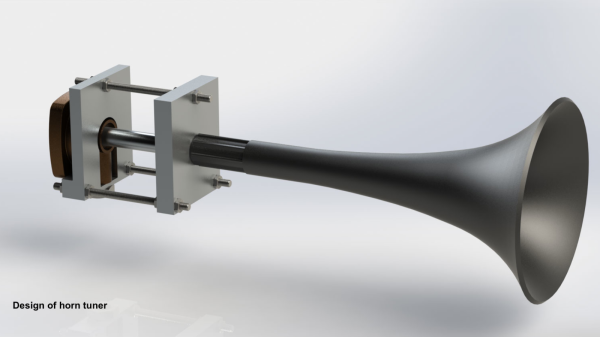
 Up close, a foghorn is loud enough to knock you off your shoes. But over a distance, its sound takes on a soulful, melancholy quality, shaped by the terrain that it passes over. The artists tried capturing this quality of the foghorn, with help from composer [Orlando Gough] who created a special score for the performance. It brought together three Brass Bands – the Felling Band, the Westoe Band and the NASUWT Riverside Band, almost 50 ships at sea and the Souter Lighthouse Foghorn to play the score.