FBI Tracking Device Found; Disassembled

[ifixit] has apparently grown tired of tearing apart Apple’s latest gizmos, and their latest display of un-engineering has a decidedly more federal flair. You may have heard about Yasir Afifi’s discovery of a FBI-installed tracking device on his car back in October of last year. Apparently, the feds abandoned a similar device with activist Kathy Thomas. Wired magazine managed to get their hands on it, and gave it to ifixit to take apart. There’ve even posted a video.

The hardware itself isn’t that remarkable, it’s essentially a GPS receiver designed before the turn of the century paired with a short range wireless transceiver. The whole device is powered by a set of D-sized lithium-thionyl chloride batteries which should be enough juice to run the whole setup for another few decades–long enough to outlast any reasonable expectations of privacy, with freedom and justice for all.

Simple AVR Based GPS Tracker

The latest project from Lucidscience.com is a simple AVR based GPS tracker. As usual, the instructions here are quite in-depth including schematics and step by step procedures all the way down to modifying cables when necessary. What we found interesting is that the GPS module he’s using is so simple. It only requires 3 wires, one for power, one for serial communication, and one for a heartbeat.

For the microprocessor, he’s using an ATMega 324, which is a bit of processing overkill but he needed the SRAM for the GPS point storage. You could obviously expand to external storage but the goal here was to keep it extremely simple. Actually, there just isn’t a whole lot here other than the microprocessor, the GPS module, and a level converter. After wrapping up the circuit he goes on to explain how to get the data into Google Earth for display. After a few trips around the block you can see the results are quite nice.

Trackuino – An Open Source Arduino APRS Tracker

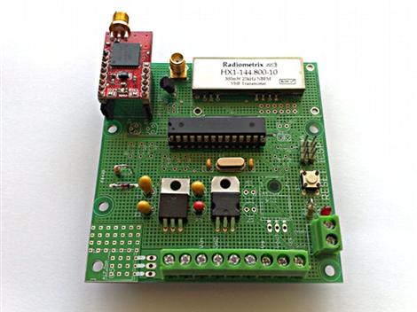
trackuino board

Trackuino is a new open source (GPLv2 license) Arduino APRS tracker designed by [Javier Martin]. If you are unfamiliar: APRS (Automatic Packet Reporting System) is an amateur radio method used to relay small packets of position-tracking data to an online database for easy access and mapping. In this case, GPS telemetry data is used to track latitude, longitude, altitude, course, speed, and time measurements in near real-time via aprs.fi.

Although this reminds us of the WhereAVR that we covered previously, the Trackuino includes an onboard radio so no external handheld unit is necessary. Since the Trackuino was designed primarily for high-altitude balloon tracking, a number of useful related features are also included: dual temperature sensors, support for a humidity sensor, and a remote “cut-down” trigger really make this a complete package.

Initially there was some concern that the 300mW radio used would not be powerful enough to reach the ground-based receivers from peak altitudes. This was clearly not an issue however, as the signal was heard from nearly 600Km away during the maiden voyage. If this still doesn’t sound like enough power, a 500mW radio is also supported.

Make sure to check out [Javier]’s blog for some amazing high-altitude photos and everything needed to get your own Trackuino up and running in no time!

Thanks [Brad]!

Magellan GPS Hack For Hassle-free Charging

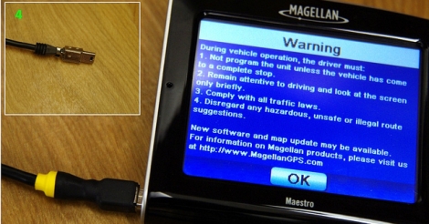
magellan_hack

Hackaday reader [Paul] recently shared a simple hack he put together via our Flickr photostream.

It seems that his Magellan GPS unit is pretty finicky when it comes to power supplies. When connected to the Magellan adapter, the GPS unit charged as you would expect. When connected to a PC, it sensed the connection and allowed its file system to be mounted, just as it was intended to do.

However, a problem arose when he tried hooking the Magellan up to a different power supply. The unit still thought it was connected to a PC, and refused to perform any GPS-related functions since its file system was tied up. Not wanting to lug around multiple chargers, he decided to see what the heck was going on with his GPS unit.

He pulled the plug apart and found that the 4th and 5th pins of the USB cable were shorted together. While most devices ignore the 4th pin, the Magellan checks to see if that pin is grounded. If so, it assumes it is connected to its power supply. If not, it assumes that it should act as if it is connected to a PC.

With this information in hand, [Paul] did the same thing as any of us would and hacked together a USB cable with shorted pins. The cable can be attached to any standard USB port or charger, saving him from having to lug around an extra adapter.

Real-time GPS Tracker With Mobile Phone Uplink

[jayesh] wasn’t actually trying to solve any clever problems when we built his homebrew GPS tracker. He just had the hacker mentality and wanted to build something fun and useful while geeking out with electronics and software.

On the hardware side, he started with an Arduino, then added a GPS module for location detection and a GMS/GPRS module for the data uplink to his server over AT&T’s network. The Arduino uses several libraries and plenty of custom code. On the server, he worked up some wizardry with open-source packages and the Google Maps API. All of the source code and hardware details are well-documented. Put together, it’s a GPS tracker that can update a map in real-time. Sure, there are commercial products that do roughly the same thing, but where’s the fun in that? The principles here can also be put to good use in other microcontroller-based projects.

Haptic GPS Sneakers For The Visually Impaired

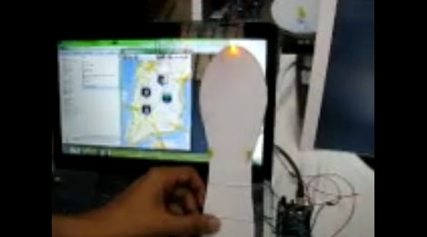
gps_haptic_shoe

The world can be a pretty difficult place to navigate when you lack the ability to see it. There are many visually impaired people across the globe, with some figures claiming up to 40 million individuals affected. While walking canes and seeing-eye dogs can be a huge help, [Anirudh] of Multimodal Interactions Group, HP Labs India, and some students at the College of Engineering in Pune, India (COEP) have been hard at work constructing a haptic navigation system for the blind.

[Anirudh Sharma and Dushyant Mehta] debuted their haptic feedback shoe design during an MIT Media Lab Workshop hosted at COEP. In its current form, Google Maps and GPS data is sourced from an Android device, which is fed to an Arduino via Bluetooth. The Arduino then activates one of four LEDs mounted on a shoe insert that are used to indicate which direction the individual should travel in order to safely reach their destination. While the current iteration uses LEDs, they will be swapped out for small vibrating motors in the final build.

We’re always fans of assistive technology hacks, and we think this one is great. The concept works well, as we have seen before, so it’s just a matter of getting this project refined and in the hands shoes of those who need it.

Stick around for a quick video about the project filmed at the MIT/COEP event.

Continue reading “Haptic GPS Sneakers For The Visually Impaired”

Prototyping With A GPS Module

[Oneironaut] is trying out a new GPS module with the prototype seen above. It’s a San Jose Navigation device identified as FV-M8 and sold by Sparkfun for just under a hundred bucks. That’s it hanging off the bottom-right of the breadboard seen above. They’ve packed a lot of power into the small footprint, and made it very easy to control at the same time. Although the device is fully configurable, you can start grabbing serial data from it just by connecting a single data line, 3.3V, and ground.

[Oneironaut] tests it out by streaming the serial data to a character LCD screen, then comparing the output to his handheld Garmin GPS device. You can see him describe his ATmega32-based test platform in the video after the break. We’re used to seeing spy-tech for most of his projects and this will eventually join those ranks. He’s thinking of putting together a magnetic tracking module that plays nicely with Google Earth.

Continue reading “Prototyping With A GPS Module”