The “absorbed device user” meme, like someone following Google Maps on a smart phone so closely that they walk out into traffic, is becoming all too common. Not only can an interface that requires face time be a hazard to your health in traffic, it’s also not particularly useful to the visually impaired. Haptic interfaces can help the sighted and the visually impaired alike, but a smart phone really only has one haptic trick – vibration. But a Yale engineer has developed a 3D printed shape-shifting navigation tool that could be a haptics game changer.
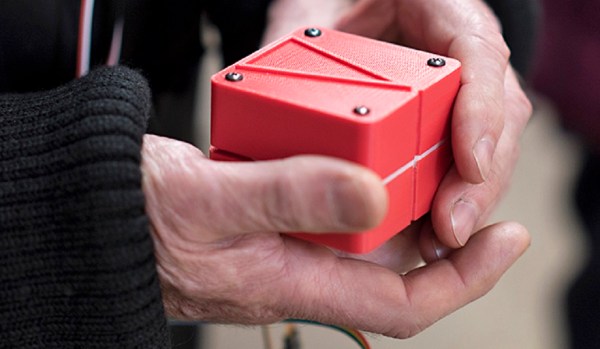
Dubbed the Animotus by inventor [Ad Spiers], the device is a hand-held cube split into two layers. The upper layer can swivel left or right and extend or retract, giving the user both tactile and visual clues as to which direction to walk and how far to the goal. For a field test of the device, [Ad] teamed up with a London theater group in an interactive production of the play “Flatland”, the bulk of which was staged in an old church in total darkness. As you can see in the night-vision video after the break, audience members wearing tracking devices were each given an Animotus to allow them to navigate through the interactive sets. The tracking data indicated users quickly adapted to navigation in the dark while using the Animotus, and some became so attached to their device that they were upset by the ending of the play, which involved its mock confiscation and destruction.
Performing art applications aside, there’s plenty of potential for haptics with more than one degree of freedom. Imagine a Bluetooth interface to the aforementioned Google Maps, or an electronic seeing-eye dog that guides a user around obstacles using an Animotus and a camera. There’s still plenty of utility in traditional haptics, though, as this Hackaday Prize semi-finalist shows.
Continue reading “Experimental Theater Helps Field Test Haptic Navigation Device”